Progress on the Uintah RW

a few sections a bit further on from wendella all needing more work.
bZX8484.jpg

cribbing was used in a lot of places on the uintah where the track strayed too near creeks.
evacuation creek suddenly becomes very much deeper where other creeks feed into it as the canyon narrows and the next section is full of sage
F7NCM1n.jpg


WVTOc3z.jpg


the creek is often full of vegetation , far more than can be seen here.
bjL7Nzb.jpg

the line runs very close to the deep creek here just past one of the few homesteads that existed in the canyon.
D8CT2Nk.jpg

this section still needs vegetating, especially on the creek banks and in the creek bed, which was mostly just a trickle for 90% of the year, unfortunately we don't have anything that could simulate that sort of uneven flow. ive adapted jangos river which he kindly let me mod so its almost see through, its a bit too wide compared to the real thing..

jWjkOpR.jpg


a lot of rock outcroppings and fallen boulders on this section
muZBK7p.jpg


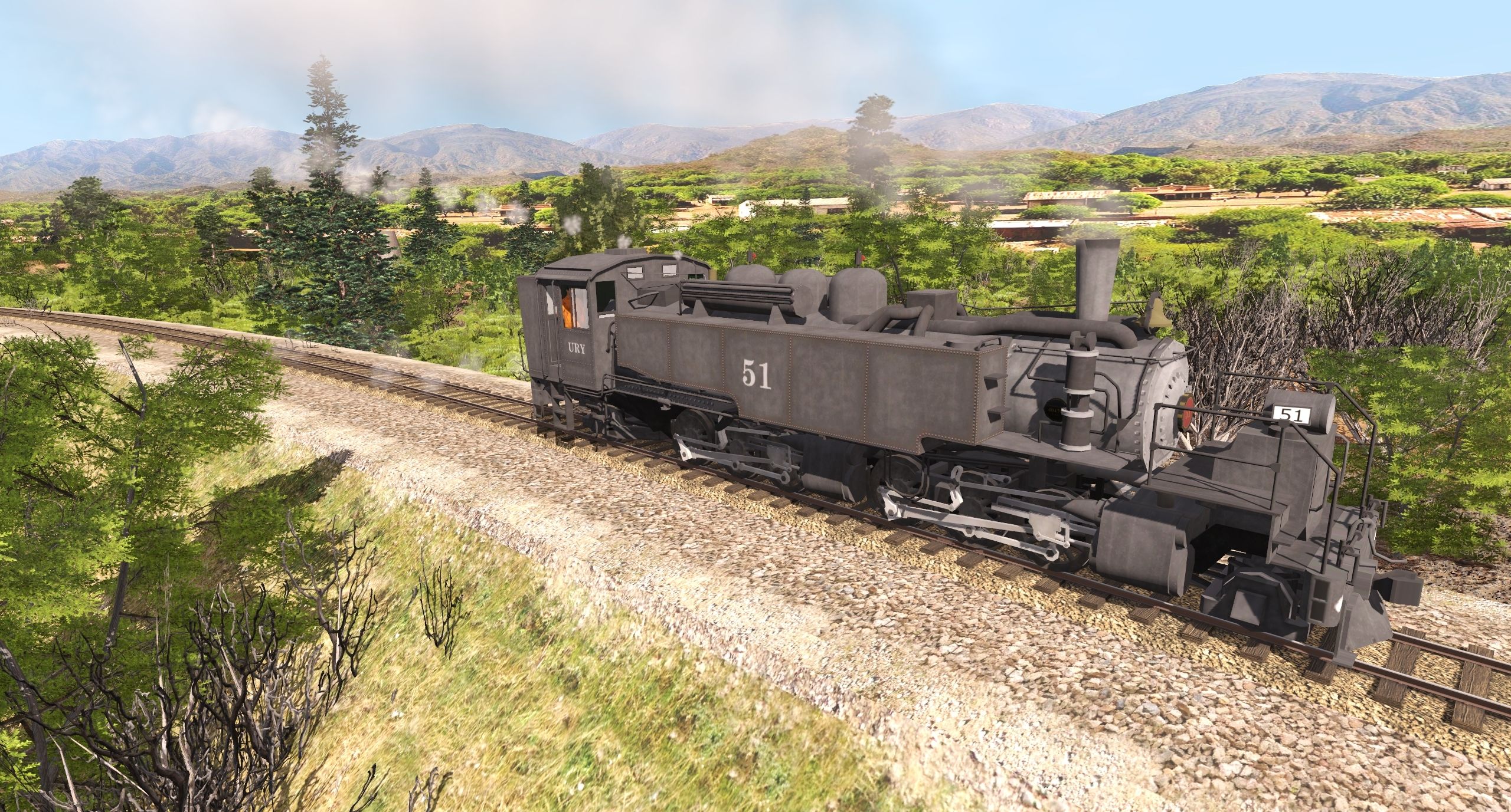
onward to dragon ! about 7 miles of canyon work to go !
hWkepTP.jpg
 
Dan,
Nice work on the route and the vegetation and other assets. This type of brush, etc. that covers so much of the western states is so sorely needed!
Dean
 
Dan,
Nice work on the route and the vegetation and other assets. This type of brush, etc. that covers so much of the western states is so sorely needed!
Dean


yeah that's why i cant understand why no one ever produced it in speed tree form, or why NV3 doesn't at least maker a few assets that would fit the bill. in desperation . once a relatively easy way to make them was given me by jvc and harold minky,I finally decided to do some myself, even if they arent top notch and they took weeks of laboriously erasing and cutting out to create.
 
near between dragon and rainbow junction there's a section which is lined shale cliffs , which i considered horrendously hard to model and I've been dreading doing it , as its impossible to get the look right using textures. Why ? , well with textures comprising of horizontal lines ,as soon as the surface changes angle the texture also changes its direction, it simply wont curve around, as a solution, I made a lot of shale escarpment splines using frank deans old escarpments a while back , so , as I'm moving round the route to give myself some variety (as ive been using sages and textures for the past two weeks until i'm sick of the sight of them ), I tried the cliffs out today, they are not perfect, but a lot better then using textures and I managed to get around 1-7 miles on both sides of the canyon cliff filled in three hours, which is pretty fast given it takes me a far longer to do other more complex sandstone cliff faces in atchee canyon , it looks ok to me and i think at least that this part of the route will be easier to complete the canyon work than it thought it would be .
the view in google earth
CzMaQ8U.jpg

in route
MBhEtjb.jpg

I will rough this section and the canyon between dragon and wendella as quickly as possible, this is about a mile from where the rainbow to cowboy section i put online recently begins . I'm very surprised I've managed to do this so easily. fortunately it doesn't have all that many trees on the cliffs only sage on the top of the cliffs so less work to do than some sections of the canyons . Dropping in many thousands of trees is hard work !
 
Last edited:
Dangavel,
I think your shale cliffs look amazing, and very realistic. You've consistently come just about as close to the real thing as possible, given the tools you have to work with. I still consider your upgrading of the Timber Ridge Route as one of the most fantastic and realistic-feeling works that you've done. When I am driving around on it, I find that my immersion into the time period and geographic area is very complete. It is very easy to look out the cab of my steam engine and imagine that I am seeing the area as it actually was. Your work is that good. :cool:

Something else to keep in mind here, is that the wind shaping and cutting the escarpments would not have been as severe during the time you are modeling. That Google Earth shot shows about 100 years more of Mother Nature's cutting, sharpening, and dramatically shaping those shale cliffs. I would venture to say that things weren't as jagged and dramatic during the time that you are modeling. So, if your cliffs are more rounded and less sharp, then you are very likely much closer to the way things looked all those years ago in the past.

Your interpretation of these wide-open vistas are what makes your routes so special. Dressing up the cliff faces with your techniques are icing on the cake. You are doing fantastic already.

Regards,
Heinrich505
 
You are too kind Heinrich, but glad they meet with your approval, I'm just happy that I can do them this swiftly as the prospect of 30 miles of intense Cliff work is rather daunting , glad you are still enjoying the timber ridge update , that was so much easier to do as there was so much variety , on a prototype, one can't just decide that " i'm bored doing cliffs , let's Bung a factory here " instead it's - look at Google earth , measure up, check, then move on ..... and it's rather difficult to do day after day , that's why I flit around from place to place to try and keep from burnout , some days are like yesterday, great progress, others are not so productive , but kind words such as yours and Blueodesseys do help sustain me when I feel it's hard to keep going .
 
I truly admire your persistence. It's insane to me the amount of effort you are putting into this despite all the difficulties and road blocks you've faced.
 
Some new cliff work. started over the last two days .... still lots to do, but this is going far more swiftly than I was expecting.
bA8SubG.jpg


Id8EUKM.jpg


LtKylvJ.jpg


di9AqDM.jpg


vo7P0t3.jpg


JKXLOIf.jpg

k4E9oOn.jpg


E3Z6rQw.jpg
 
thnaks for the fix, but i do have a version of the engine that has the correct numbers of cylinders, never noticed the other version has three, not something that one tends to look for or expect, .. anyway that means theres another item i can junk as there no appreciable difference between either version other than the cylinder issue. :-)
 
i;ve been working on the sections towards Dragon and around dragon mine, so will feature mostly complete bits , there's still an awful lot to do , but making steady progress .
qsBoQKb.jpg

some of these cliffs should be on the dls by now. had to rework this entire section as the old cliff work was looking very shabby , surfaces are also being re-textured, the whole area is covered in broken rock , so flat surfaces just aren't the go.
Es8zyad.jpg

overview of Dragon including the company houses

JaAGHte.jpg

leaving the station passing the ticket office ( by 1930, it wasnt much used ) note this version of no 51 has the right number of cylinders. :)

VXnI8Ri.jpg

getting these high cliffs to look anything close to the real thing is impossible, this is about the third reworking of the cliffs in this area.
JdZfyHH.jpg

still work to do on the other side of the valley , fortunately most of the cliffs are on only one side throughout the route, its the 8 mile stretch between Carbonera and Atchee that has the highest and most formidable cliffs to create. Paul in Canberra is working on some new escarpments for me and hopefully we can make better assets to use on that and these sections.
wNQYbxq.jpg


view up Dragon canyon to the mines, I've also renewed this section and will feature some more shots of this bit soon ....
 
Last edited:
Here's some of the latest work in dragon mine canyon. Slugsmahers old shay , reskinned as uintah number seven takes a load of empties up the canyon to pick up gilsonite back to Dragon , this is the first time I've actually driven anything for more than few minutes in trainz for about five months , took forever to load these flats as the loading is a bit temperamental , its taken four years to get to this state, with contributions from three talented model makers in making cliffs and items for the mine , to whom I'm incredibly indebted.
LjJNqk2.jpg


4QyRWbc.jpg


KBAwzib.jpg


uwKhPMP.jpg


um3rWQx.jpg


vAIg9He.jpg


sB4vUTA.jpg

At one time there was a large boilerhouse here as well a number of company houses around 1910-1920, but by this time the mine was largely played out and more gilsonite was being mined at rainbow. ore was still being moved down from mines like Rector as well as minor excavations at dragon mine itself
 
return journey

in the late 20s they made this new loader which was much smaller than the old Black Dragon mine tipple . Ben Dorsey made this later version , but he didn't live long enough to make the older one , which i'm sure he would have loved to have done as he was mighty keen on making such structures.We really don't seem to have many new modellers who create these sort of interactive items. which is a great shame as NV3 shows no signs of creating any to replace the older items.

Cv0GSdx.jpg


p1gvcoQ.jpg


1W8s4Ee.jpg


this strange contraption was the ventilation shaft installed after a major fire in the mine, its still there actually , now nearly a century old.

zWFDxOX.jpg


deMMONF.jpg

number 7 passes the old cemetery, which is the opposite side of the dry creek bed. you can just see the crosses on top of one of the graves, thats still there too.
IjWxLH6.jpg

a mile down the line we're back at Dragon

8GgoGYa.jpg


6YXNCVQ.jpg

there used to be a smaller wye just up the canyon last the school , but when they made the extension to Watson they removed that and made this larger wye that more or less enclosed most of the "towns " buildings, such as they are.
 
Last edited:
Finally a few shots of the canyon towards Watson, I've worked on these cliff faces and found ways to make them more vertical.
sadly a lot of the rolling stock and locos that were made for this line are showing their age, hopefully at some stage they will be updated by some kind soul, but it seems obscure NG is a low priority for most builders at this time apart from Togog, is there ANYONE out there who could make a shay , the ones we do have are all pre 3.5 build, so no reskins can be put on the DLS a very sad state of affairs.
RWU5NbI.jpg


UokADl2.jpg


9JtzPCy.jpg
 
Last edited:
Dangavel,
Stunning shots of the route! They are truly works of art. The late afternoon lighting and shadows make your shots even more dramatic and picturesque. They really show off and highlight your work on the cliff faces. I'd say your work on Timber Ridge was just a prelude to your masterpiece here. What a wonderful job you are doing with the route.

Regards,
Gary


Thanks, i must admit the main thing i prefer in 2019 is the lighting, i can never seem to get good light at noon in tane , whereas evening and morning are generally pretty good . Most of the time recently Ive just been rushing screen shots, just too busy to bother with settings , but today I decided to have a longish drive so spent a bit of time getting the lighting right. it also hides imperfections :)
 
Back
Top