Master Map maker needed

Guys, BLACKWATCH has been with us for many years. While I don't particularly condone his internet manners, I have learned to take him with a grain of salt (most of the time). I see him as a colorful, cranky, old Englishman, toddy (or pint) in his left hand, quaintly stumbling along, while trying to reach out to us 'Yanks'. He has often been helpful to us Trainzers over the years, and often shows some signs of 'socially redeeming value' to the community.

Remember that anyone who shows any sign of character or cheekiness is flamed as a troll on here ;)
 
I feel like people are going to get mad at me for posting here but, its taking me a fair while to do my route I'm doing, I haven't even started the actual line. But since you're new I'm guessing you got the game and thinking "I want this really big and awesome looking route to drive trains on" I think everybody is like that when they get a game like this, just give it your best shot, yes it may take practice but hey, maybe you will become a great route builder.

- Austin
 
Well, as far as Blackwatch is concerned, while he ardently claims to be an Englishman, his user ID on the forums brings to mind none other than the 3rd Battalion, The Royal Regiment of Scotland! That, to me, says enough.

ns
 
It seems to me that the Blackwatch, while known as the Royal 42nd Highland Regiment, greeted us 'Yanks' at Long Island, Harlem, Brandywine, Germantown, and Monmouth; as well as the siege of Charleston. It might be noted that the regiment declined battle honors in those engagements due to conflict with 'kith and kin'. A most honorable position, indeed.
 
As geophil pointed out above, if you have TransDEM you should be able to generate quite an accurate Trainz map. Good luck on your project.
 
But is he a "master map maker" ? "As this is the topic of this thread".

Progress so far: We have traced the line on GE, and have found a railroad gradient chart for the EBT ... looks very challenging ... but quite fun !
http://davecathell.tripod.com/ebt5.html

Well aside from the degraded signal to noise ratio, what you've written above about the 3D problems tells me you got more than just some ducks all lined up in a row. Seeing as how it's PRR territory (The map was a good touch--grounding like to see such, as the scope is there). Me thinks you need to shag butt into yesterdayztrainz and get your application in. Didn't you PM me about joining last week? We're likely to be covering at least the connecting route to the EBT and we're still looking for a good sized starter project, so make a pitch.

I don't want to over commit, since we're just shaking out and I'm resolved to get the Wikibook squared away and put up some good newbie tutorials and likely videos covering those skill builders and more after that, but you got me interested. Enough that I'm willing to almost commit to offering to help. (Kinda like a gal that says she wants to, but then won't uncross her legs, that. Sorry. I once dated most of 'em I think!?)

Turns out watercourses is a pet peeve of mine, so my layouts always begin with getting those straight, before sundries like roads and rail roads get laid in. Jcitron even lays down towns after the roads then integrates the roads, and that seems right too. Tracks first ala basement H.O. modeling doesn't integrate as well.

Frank
 
I spoke with the OP, and he sounds like a very intelegent fellow, who has a huge knowledge of the EBT, history, and trackplans. So this route will be one of my 5 routes that I work on (sometimes one must have several routes going on, to break up the monotony).

The EBT had 2 tunnels near Kimmel and Coles, and that is where I am starting, and the OP advises me that the EBT had a maximum grade of 2.75%.

Oh too funny, it encapsulated your map in the quote... dominated my write area...

comment was, Yep, that looks like my Pennsylvania... ridge after ridge of people tucked into hillsides.
And I'm planning to do up a series of generic Victorian era housing and public buildings with deep foundation 'seats' suitable to be set into the hilly geography's there sometime this summer, you may find that useful once I get rolling. It's a pain to set a flat, no basement skirt house onto a typical Pennsylvania valley's slopes, and all those company towns kept the flat lands and bottoms for the company... the workers got the ski slopes--and more often than not, had to plow them too in the winter!

Frank
 
Keep in mind that any MicroDEM/HOG/TIGER-based Trainz route is an individual product and usually cannot be merged without gaps with any other MicroDEM/HOG/TIGER or TransDEM route module.

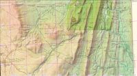
I did a quick search and found the likely source of the map clipping there: http://davecathell.tripod.com/ebt5.html
It appears to be the north-east part of the 15' quad of the 1933 edition:
http://historical.mytopo.com/quad.cfm?quadname=Broad Top&state=PA&series=15
Projection is Polyconic/NAD27, but can be georeferenced using UTM/NAD27. Steamboateng has lots of experience with those maps, he worked with them for his Hoosac Tunnel project.
 
Last edited:
As it made me curious: Here is a screenshot of the 15' quad from 1933, georeferenced and put on top of the current 1/3 arc sec NED DEM. At the top is a WMS clipping of the much later 1:24k USGS topo map (click to enlarge):


The old right-of-way is still visible in the later map but no longer shown as railroad track.

(The slight discrepancy between the 78° 05' grid lines in purple and black is caused by the different datums. The black line on the map is NAD27, the purple line NAD83.)
 
I just checked the USGS site again. There are 15 deg. topo maps from the 1920's and 1940's which show the EBT trackage. Those map cells are Union City, Orbisonia and Broad Top. The maps do show the mainline trackage, but unfortunately their large scale shows little detail on buildings and sidings, etc.
 
Hi All
Please remember to keep on topic and friendly.

It isn't appropriate to make personal attacks, against any member.

@bigboy4014
As you have found, most members don't take too kindly to people asking other members to take on a big project for you. If you wish to see a route, such as the EBT, created for Trianz, then your best bet is to create it yourself. If you make a start, you might find other members will be willing to assist you with the project over time.

Regards
 
John, that looks like a dynamite reference site. Thanks for posting it.

Mike, you've got more than a few of those up your sleeve too, probably in shortcuts or bookmarks. Let's start getting these listed on the group board:
http://forums.auran.com/trainz/group.php?groupid=90 under 'Useful Sites' or some such name... and perhaps our website, once Ted figures out how he's arranging stuff.

John and I figure to do the same for links to good tools too, all with a little blurb explaining what it is and why it's useful in Trainzing.

IIRC, you posted http://nationalmap.gov/historical/ somewhere... so there's two good ones to start with. // Frank
 
Keep in mind that any MicroDEM/HOG/TIGER-based Trainz route is an individual product and usually cannot be merged without gaps with any other MicroDEM/HOG/TIGER or TransDEM route module.

I did a quick search and found the likely source of the map clipping there: http://davecathell.tripod.com/ebt5.html
It appears to be the north-east part of the 15' quad of the 1933 edition:
http://historical.mytopo.com/quad.cfm?quadname=Broad Top&state=PA&series=15
Projection is Polyconic/NAD27, but can be georeferenced using UTM/NAD27. Steamboateng has lots of experience with those maps, he worked with them for his Hoosac Tunnel project.

Geophil, thanks for that dig out. If you were as close as Mike, I'd buy you a beer. That link and history: http://davecathell.tripod.com/ebt5.html was quite informative, and this kind of history and project has always been fascinating to me. Can you sip through a fiber-optic cable and satellite up-feed? Never mind, you have better beer over there than I could send, save perhaps for a Sam Adams special run. // Frank
 
Back
Top