NYCTA! pics!

That's the tricky part. Making a good looking subway/el line in NYC. So many different towers, apartment building, co ops, streets, lights, etc... How can we make NYC look good in trainz without putting too much stress on the graphics card and CPU? For the Q, maybe it can run along St.Anns avenue, turn near Hunts Point, and end near Hunts Point around Randall Avenue. I can just picture it. Or maybe instead of St.Anns avenue, it can run near Mott Haven by the Metro North.
 
Last edited:
Probably using building splines or Ish6's city buildings--they're great and simple as far as polys go. I wouldn't go too too in detail about which buildings go where, but enough to be realistic. I'll create NYC type traffic light poles with re-nameable street signs. Seeing as they don't use block numbers on the signs, it'll be easy :D

IND 1939 Extension Plans:

1939_IND_Second_System.jpg


-A :wave:
 
Last edited:
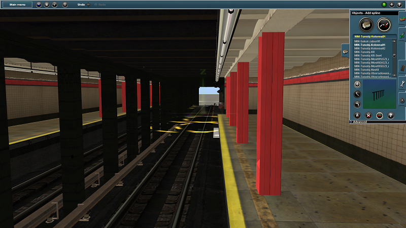
I just discovered that AlTerr's v3 of Moscow Metro's tunnel package actually integrates perfectly with the current v3 of the NYCTA subway station kit. Below are some pics of how perfectly they mesh together.

At the end of this post is the link to the .cdp for the Moscow Metro kit.

trainz2012-10-3023-47-12-72.png


trainz2012-10-3023-49-01-28.png


trainz2012-10-3023-48-48-86.png


http://rutrainz.com/?p=314

On the website it'll say Version 2.0--I have version 3.0, but I don't know if that's available on the site or not. Since I don't have the developer's permission to release the cdp, a Google Search might aid you guys. Either way, there's no real difference between the two versions except some new pieces in 3.0

-A :wave:


U did an outstanding work! now, keep it up acelejalde!
 
Last edited:
*stack quote of images*
U did an outstanding work! now, keep it up acelejalde!

How many times do we have to remind you people not to quote long posts of images?! It unnecessarily wastes space and slows down load times for users with lower-end networks. It makes for a stupid, pointless, and annoying message. So please, don't do it.

Back on topic, they really planned to connect the IND with the SIR? That's really interesting. I wonder what it must be like to ride a subway on the longest cable suspension bridge in the United States?
 
If there was no World War II, no Great Depression, and no terrible accident near Prospect Park station on the Brighton Beach route in 1918, Brooklyn Rapid Transit would have built a tunnel between Brooklyn and Staten Island. The accident happened and the tunnel was abandoned. Look closely at the 1939 IND plan map. The tunnel that was to be built by IND was north of the bridge, near Staten Island Ferry terminal. When the bridge was built in 1960s, Robert Moses stopped the city from building tracks on the bridge.
 
Probably using building splines or Ish6's city buildings--they're great and simple as far as polys go. I wouldn't go too too in detail about which buildings go where, but enough to be realistic. I'll create NYC type traffic light poles with re-nameable street signs. Seeing as they don't use block numbers on the signs, it'll be easy :D

IND 1939 Extension Plans:

-A :wave:

Hi A,

I would suggest using Dave's massive low rise building collections which are designed for elevated type of layouts, etc!!!

Basically is the illusion of having contents surround the track work, etc .... which is, easier said, then doing it!

Take care
Ishie
 
If there was no World War II, no Great Depression, and no terrible accident near Prospect Park station on the Brighton Beach route in 1918, Brooklyn Rapid Transit would have built a tunnel between Brooklyn and Staten Island. The accident happened and the tunnel was abandoned. Look closely at the 1939 IND plan map. The tunnel that was to be built by IND was north of the bridge, near Staten Island Ferry terminal. When the bridge was built in 1960s, Robert Moses stopped the city from building tracks on the bridge.

Thanks Jeff for that bit of history --- did not know that!!!

Well done
Ish
 
Update: I'm creating the City Hall loop as a static object, so Ethan's suggestions in the other will be implemented (fix the platform width, natural lighting, curved walls). I've discussed it with B, and since it's only used on one part of the system, We can "spend" a little more polys on it.

Also, terminal pieces like magicland's are being built for all the subway stations. Once they're matched with B's tunnels, they'll be released. Tentative release date is the end of this month for the Stations and Tunnels, assuming B and I have no personal catastrophes or problems that get in the way of development (The guy upstairs always finds something though...)

-A :wave:
 
Probably using building splines or Ish6's city buildings--they're great and simple as far as polys go. I wouldn't go too too in detail about which buildings go where, but enough to be realistic. I'll create NYC type traffic light poles with re-nameable street signs. Seeing as they don't use block numbers on the signs, it'll be easy :D

IND 1939 Extension Plans:

1939_IND_Second_System.jpg


-That's what jeffmorris based nycta2007 on
 
Smh to all of you people quoting the god damn pictures.

As a matter of fact, BVEStation made the (G)(K)(Q) and <X> to New Jersey or Staten Island via the South Brooklyn Line. Pretty interesting routes.
 
Easy, easy trainguy--no profanity. I'm just as annoyed, but let's stay in check. I've driven some of the SI BVE routes, and the set up was pretty cool. Also, here's something I'm currently working on with help from PEV, Shaneturner12, and Ish6's input and expertise for the platform signs. They'll be editable objects:

newsigns.png
 
WARNING! ACHTUNG! ATTENTION! iCUIDADO!

Anyone quoting multiple pictures not relevant to their message will be reported for spam.

Wer zitiert mehrere Bilder nicht relevant, um ihre Botschaft wird für Spam gemeldet werden.

N'importe qui cite plusieurs photos ne sont pas pertinents à leur message sera rapporté pour le spam.

Cualquiera citando varias imágenes que no son relevantes para su mensaje será reportado como spam.
 
Easy, easy trainguy--no profanity. I'm just as annoyed, but let's stay in check. I've driven some of the SI BVE routes, and the set up was pretty cool. Also, here's something I'm currently working on with help from PEV, Shaneturner12, and Ish6's input and expertise for the platform signs. They'll be editable objects:

PICTURE

Ok, I will cool it down, it was uncalled for.

Like the idea. What I am worried about is how we can edit those objects. I mean, the sign name goes for itself, that would be easy. Now the bullets is quite a challenge if you ask me. Getting them is easy, but incorporating them into the object is the catch.
 
It's a matter of combining two scripts. I've already got the technical parts down. Just making the mesh currently :) Expect some updates later on tonight! And to answer your question, you'd edit the object in the properties tab, and select the bullets/diamonds you'd want and then edit the lines of text to say whatever you'd like :D
 
It's a matter of combining two scripts. I've already got the technical parts down. Just making the mesh currently :) Expect some updates later on tonight! And to answer your question, you'd edit the object in the properties tab, and select the bullets/diamonds you'd want and then edit the lines of text to say whatever you'd like :D

you know (just for my thought/point of view) if u make the options in the properties panel, do you think u can add like graphics (GUI and/or images) to give it a little 'pop' to? That'll also give the user the find of what that option do, (based on the image you showed us earlier about the parts of the station sign you are working on on this post).
 
Last edited:
Back
Top