Looking great!
Can't wait for the release.
I'm looking forwatd to running somone elses version of this route, I;v been working on my own for some time
Lets see some of your shots then of this area :hehe:
Follow along with the video below to see how to install our site as a web app on your home screen.
Note: This feature may not be available in some browsers.
Looking great!
Can't wait for the release.
I'm looking forwatd to running somone elses version of this route, I;v been working on my own for some time


You're very welcome. But don't expect the 4 track one to be out soon, I'm going to finish the 3 track first, then add the 4th track and release it in one big pack. I'm also waiting for a friend to finish a static K4 for the park and I'm looking for other custom content creators too. I think I should of said coming Fall 2008. Anyways here's brickyard, I need to fix that slope and get better crossings... Don't recommend bnsf50's, this will be an 04 route.
How far east are you going? If you want we could meet at a certain point. Also have you seen the proxings on DLS? I've been studying roads in trainz and the gfisher roads are made at car level or 0.40 meters above ground, Simply lower the roads to ground level, add invisible no traffic roads to each end and to the crossing and slide the road under it. I think I might do that.Take your time...Fall 2008 is perfect. I hope to merge your curve with my Bethlehem Steel C&BL route in Johnstown. Then steel railcar parts can be hauled from Johnstown to the Altoona shops.:Y: This plan would require another route in between Cresson to Johnstown plus the Southfork Branch to get coal. My route is also TRS2004.
I also had difficulty in finding suitable grade crossings for 04. If you find some please post the kuid I'd like to have them also.
How far east are you going? If you want we could meet at a certain point. Also have you seen the proxings on DLS? I've been studying roads in trainz and the gfisher roads are made at car level or 0.40 meters above ground, Simply lower the roads to ground level, add invisible no traffic roads to each end and to the crossing and slide the road under it. I think I might do that.
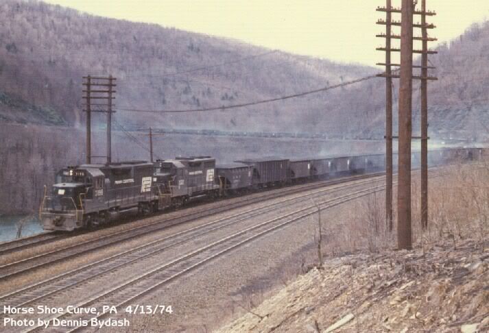
Looks great. Where you the guy at the conrail club booth on the curve back on the exscursion trainweekend. Or that might be someone else.
Davis
Cool, The DEM I'm using goes to South Fork.Right now I am almost to Mineral Point PA which is west of South Fork PA.
Cool, The DEM I'm using goes to South Fork.
I've almost completed the trackwork between Altoona station and the RJ Corman interchange in Cresson. I'm also redoing the kittanning reservoir.
That wouldve been me sir........ I've been working on my own version of this too...im going to be doing mine in 2006 and im workin with some others for custom content as well.
Kevin
Cool, I merged 06 and TC together, so I never really have problems. How far have you gotten, are u going all the way to pittsbrugh?
Davis
")
Cool, I merged 06 and TC together, so I never really have problems. How far have you gotten, are u going all the way to pittsbrugh?
Davis
It's about 350 meters...What elevation are you at in meters at South Fork?
Cool, I merged 06 and TC together, so I never really have problems. How far have you gotten, are u going all the way to pittsbrugh?
Davis
Pittsburg, Harrisburg, no. To far away. Maybe South Fork.Yeah, don't try to do something too big to handle. And i presume harrisburg will not be made either because it's kinda the samed deal or are you considering oit?
davis

It's about 350 meters...
 It would take approx 25 baseboads at 2%+ grade to connect at 0 meters. That would be appox 12.5 miles from Southfork to Johnstown in its current form. Actual distance is more like 8 miles. Could be done but that's a lot of work. May do it anyway. We will see once your route is released. Keep going!:Y: