socalwb909
Photo Creator
- i know that there is one in the works for the b40-8w. Should be in the next release here soon!
-Joe
-Joe
Follow along with the video below to see how to install our site as a web app on your home screen.
Note: This feature may not be available in some browsers.
Sweet ha ha sorry I read what I wrote I'm sure that was confusing to read.- i know that there is one in the works for the b40-8w. Should be in the next release here soon!
-Joe


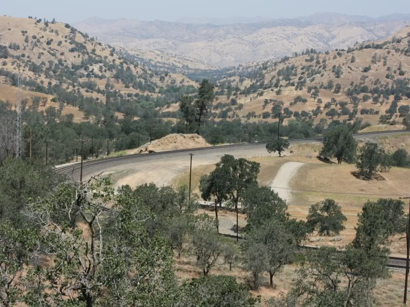
Hallo,Joe, here's a pic of the hill at the end of the siding and a pic of the ranch house at the loop. If you need any more let me know, I go by there periodically.

")
I see. You must be a lucky one, as you can go out to spend some time in the area you are creating. One day I just decided to go for the Milwaukee Road, although its long gone and much have changed and the satellite maps does not look back in time. Another thing is, that I life in Germany and I have never been in one single place I am about to simulate, not even to see the remains.-thanks Tume! i took the extra time to place each tree in the right place as it is in real life, thanks to transdem google earth utm tiles. it took around a week just to do the loop area and it still needs some fine tuning! but in the end it is well worth it. i like the fact that when i set the camera in areas where i have been at the loop in real life, it brings back some memories... looks just like it but a computer version lol!
-Joe
I see. You must be a lucky one, as you can go out to spend some time in the area you are creating. One day I just decided to go for the Milwaukee Road, although its long gone and much have changed and the satellite maps does not look back in time. Another thing is, that I life in Germany and I have never been in one single place I am about to simulate, not even to see the remains.
But I agree sometimes during all the work at the simulation it gives some kind of imagination about the real thing.
Your's TUME
-well you have more ambition than i do! i dont think i would attempt to do a RR that is no longer in existence. i've looked at the avery to drexel route in google earth and it shows close to nothing. so what you have done for the community is nothing short of amazing! yes, being in a place that you are modeling does help quite a bit rather its pics you took or if its all in your head. i know for my next route i will try to do in a place i haven't been, just because i like the challenge! we'll see what the future has for me!
-Joe
-That is a lot of money and time but it will be worth it come your release time! Lucky for me i know people that work for the railroad and have plenty of photos, videos etc. Thanks for your input Fred!Great work, Joe! Making a virtual layout that is geographically removed from where you live is challenging. That's why I do it. Be forewarned, however, that, in order to do it properly, you will need to make a substantial investment in research materials...much the same as if you were modelling an HO layout of an area far from your abode.
I've been working, excluding breaks, on the Hudson thing for about 3 years now. I think it is safe to say that I have spent around $1000 on research materials. But...hey...it's amazing how much you learn...and how much fun you have in the process. That's what Trainz is really all about. Keep it up!
Cheers,
Fred


Nope no activity when I was there this time but I was only there for a few minutes. That maintenance foreman, Rusty has taken all the joy out of train watching there by forcing every body out. I've never met him but I hear he's a real a^^ hole and that came from a guy that works the mountain work train. You can't even get to the hill that everybody, including myself used to park on, as he's dumped iron and ties all over the place to prevent you from getting to it, plus the no trespassing signs. I took these pictures from the Woodford hwy with a telephoto lens.-Thanks bnsf50 for the pics! did you happen to see anything go east or west during your visit?
-Joe
 The tree on the mound that I always stood near shure has gotten taller!:hehe:
 Where did you get that track?