Basemap"A"-Getting GoogleEarth&Map Images Overlayed on Baseboards...How you can do it

Using Basemaps in TS2009

It has taken me a long time to figure out how to get Basemap(s) to work. And putting maps and photos from Google Earth and such, is much easier than I had thought. It is really simple. I will relate more, as you post here. Anyone else having problems understanding Basemaps feel free to post here.
I read this forum and still had difficulties with Basemaps in TS2009. I finally figured it out and for those who may be still having trouble I have posted a description of how I am using them on Jeff Gale's website "White Pebble Rapids RR". Go to:
http://wprrr.110mb.com/index.html and click the “How to” button.
On the "How to" page go to “2009 How To’s Tutorials” for a downloadable pdf.
 
Here's what I want to do, I am building a freelance RR. I am drawing it out on paper, scanning it, then making it into a base bored. All is going well.

But what I want to do, is, I want to take drawings form Model Railroader of others routes and use segments of them. And maybe make a few of the routes they have in there. How would I brake up an HO scale drawing to fit on a 1km base bored? If they have grids of 1 grid=23inches, or 1grid=12inches, how would I convert that?
 
A Basemap A is exactly square 1x1km...any photo should be 1km in size, or measured and shrunk down to that scale...any 1024x1024 jpg image will be usable on a Basemap A...

A Trainz baseboard is 720m x 720m...so a Basemap A is larger than a single baseboard.

Ther is a ruler in Tools for measuring on a baseboard.
 
Last edited:
The basemaps are all 1000 x 1000 squares 1k scale is not important. Open trainz and lay two blank baseboards use HO scale and then measure 1000 squares. This will give you the length of an HO drawing required to fit the basemap. Trainz always builds in full scale so the different scales available are only for those who, like you need to convert a scale model into trainz.
 
TransDEM

I am a TransDem fan, so can't help but put in my two cents on the subject. This exellent program, created by Herr Dokter Ron Ziegler, does most of the work for you. TransDem will take any georeferenced topo or google earth map and will apply it as a base map overlay (really underlay) as 1000m square UM objects. The program will create and number each map object, make them available for CMP import, and place each map in Surveyor on your base boards along with DEM terrain, in one step.
The keyword here is georeference, which is accomplished with the program, matching the topo or google earth map to the DEM data map.
DEM data and topo downloads are available from the USGS site at no charge. (Your taxes pay for it-use it!)
Can't applaud Dr. Ziegler's TransDem too much. If your into DEM terrain creation, this program is well worth its $27 pricetag.

Regards
Steamboat
 
I read this forum and still had difficulties with Basemaps in TS2009. I finally figured it out and for those who may be still having trouble I have posted a description of how I am using them on Jeff Gale's website "White Pebble Rapids RR". Go to:
http://wprrr.110mb.com/index.html and click the “How to” button.
On the "How to" page go to “2009 How To’s Tutorials” for a downloadable pdf.

Great tutorial buddy!

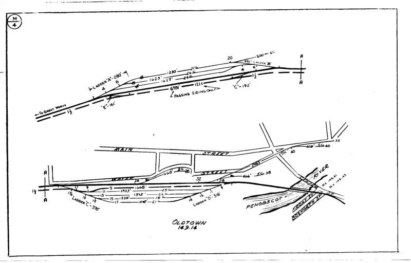
Now I plan on doing this, but not using google earth or anything like that. Instead I have an entire database of track charts for the rail road I plan on modeling (Maine Central). Now these maps are perfect for this type of thing. The only problem I have is there isn't really anything to use to scale the image to 1km x 1km. There are track lengths written on the track tho.

M4.gif


This is actually a really high resolution scan of the track map. So enlarging or shrinking the image to the right size for this shouldn't be a problem. It might be hard to see in this example but there are track lengths and car counts on each track. I have about 500 more images like this and it would be great if I could import them all to 2009 and do an entire route.

Maybe someone can help me figure out how to scale these properly for use in 2009. All help is greatly appreciated.

-Joe
 
Only thing I can think of is from the drawings copy a long straight section of track and place at the bottom. Place sections next to each other until you have the required basemap length of 1K. You could divide the line by 100 to show 10 grid square sections. If all maps are of the same scale you just copy the 1k line to the other maps.
 
im trying to use google earth and am having trouble , i do not have paintshop or photoshop, or even gmax is there a way around this.
 
Hi stmsoccer,

I made a basemap set, 720x720 basemap, kuid2:97008:7201:1 to5
(there are 5 maps in this set for multiple use) crop a GoogleMap image
(or other) to 720x720m and save it as a 512x512tga image and name it basemap1 , then save it in this folder and overwrite the existing file.
Then import it into Trainz. It appears 1m above the surface,
lower it below ground level and switch wireframe on or off (F9) move and or rotate to suit. "

Hope this helps,

Cheers,

Bill.
 
I cloned BasemapA, 200 times, and renamed "Username" in its config file, now I have 201 Basemaps, all custom labeled.:cool:

The MS Snipping Tool is a great way to capture a square 720m x720m, 1Km x 1Km, 1040 x 1040 image from your PC Monitor screen.

Irfanview or MS Paint are easy to use, to copy and paste GE images, from your PC Pictures file, onto Basemaps.
 
Last edited:
Ok. I fiddle farted around for hours with Google Maps with no decent progress. However, I did manage to find this great tool for Google Earth which allows you to draw a grid over the area you want, and the best part is that you can select the size of the grid squares. So just using 720x720 grid squares, select the area you want and drop them onto Willem's 720 Basemaps. Hold Ctrl+Shift when placing your basemap to snap it to the centre of the baseboard and you will have a perfectly aligned map to 1:1 scale.

No more stuffing about assuming the scale is correct or trying to line up grids you're not sure of.

:cool:
 
Basemap A-Z

hello i have done what said, I typed the word base map every which way
possible. and it still comes up with no downloads available. am i doing
something wroung? thanks again for your help...:(
 
basemap
Title search

Make sure you have all the versions of Trainz boxs ticked off, up to, and including your version ?

Do you have a FCT, or authorized access to the DLS ?

There are 1km x 1km which takes 4 baseboards to show ... and 720m x 720m which fits on 1 baseboard.

The "Square A" image is easiy edited in MS Paint, and you stetch it overall the white area in 25% zoom view.

The "MS Snipping Tool" is the way to capture your 1km x 1kn or 720m x 720 Google Earth image or Topo Map image.
 
Last edited:
title search

Yes, have had access to DLS for several years. no fct though, But have
all trainz ver. And auran has all of the serial numbers
 
Me thinks, you need a FCT ... for all your Trainz versions shown, are obsolete, or soon to be obsolete, as 04/06 is unsupported now, and a FCT is now maditory in 04/06.

A 1 year FCT costs @ $19 USD and is SUPER Fast 375kbs DL speed !

KaChunk, KaChunk, KaChunk, Mooooooo !
 
Last edited:
PLEASE HELP!!!

Hi, all! So, I have been trying for several days now to superimpose an aerial photograph onto a basemap object in TS12 surveyor, but to no avail. This is what I have been doing:

1. Screen capture the aerial photo image from Google Maps
2. Import the image to Photoshop
3. Scale and crop the image to 1km x 1km square
4. Set the image resolution to 1024 x 1024 pixels
5. Save the image as a JPEG with the appropriate name; 1km square a.jpg
6. Replace the existing JPEG image file with my aerial image file of the same name in what I believe to be the "1km Basemap A" object folder, which is;
C:\Program Files (x86)\N3V Games\TS12\UserData\original\hash-2B\kuid 267614 100067

However, when I launch TS12 Surveyor and place the "1km Basemap A" object, the original default image (the blank white background with the large letter "A" in the center) still shows up as opposed to my aerial photograph. Can anyone here tell me what I am doing wrong? Thanks in advance for any help and/or troubleshooting tips that you can give me!

-Ed
 
You use somehing like MS Paint at 25% zoom, and copy and paste your 1km x 1km image, and stretch it overall the white area in the original file: "BasemapA Square" ... now instead of white ... it will be your image.:cool:

PM me if you need help

All you need is the Google Earth ruler set to Kilometers/Path, and draw an "L" ruler path a total of 2 Km long, as a guide. Using the MS Snipping Tool, snip a 1 Km x 1 Km image, copy and paste it overtop of the opened "BasemapA Square" image.
 
Last edited:
Back
Top