I've been able to get a my DEM into my TRS2019, I followed a tutorial on YouTube where you make a path for your route in Transdem and you open it up in a different format in "Javaopenstreetmedia" and put it back in transdem and export it into trainz. My issue is not being able to get the height elevation for the tracks and the roads instead I only got the height elevation for the terrain and the hills of the area I'm mapping out? Is there a way I can get the actual height of the roads, tracks or even the sea level?
Install the app
How to install the app on iOS
Follow along with the video below to see how to install our site as a web app on your home screen.
Note: This feature may not be available in some browsers.
You are using an out of date browser. It may not display this or other websites correctly.
You should upgrade or use an alternative browser.
You should upgrade or use an alternative browser.
TransDEM Elevation help
- Thread starter jamal17
- Start date
Unless you have good contacts to your railway or road administrations the answer will be no. Open Street Map vector data is 2D only. However, if you are able to obtain a hi-res 1m LIDAR DEM for your route, you will get all the cuttings and embankments nicely shaped into the terrain. That way, taking the vector data z component from terrain elevation can be rather accurate.Is there a way I can get the actual height of the roads, tracks or even the sea level?
jeffmorris
Active member
Is there hi-res 1m LIDAR DEM for NYC area?
Is there hi-res 1m LIDAR DEM for NYC area?
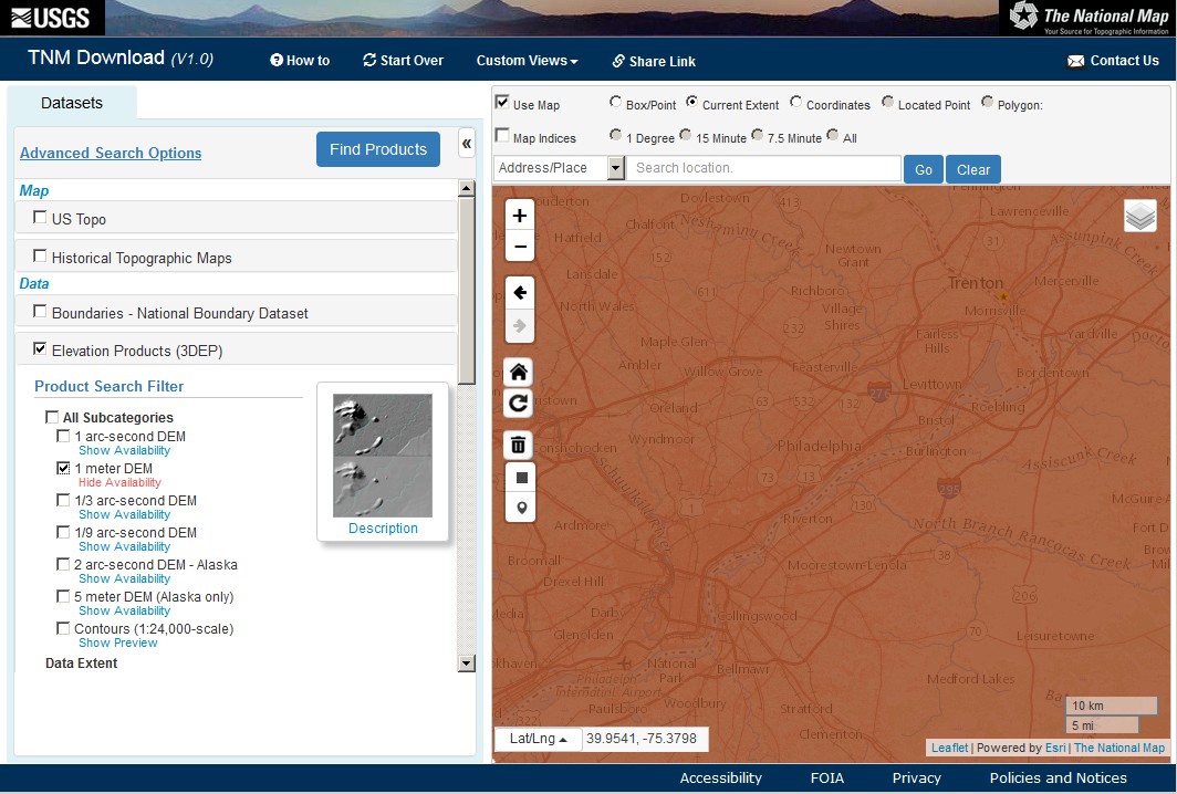
Yes, for part of the area. Check with the National Map Viewer. File format is .img. UTM zone is 18. Fill up with 1/9 or 1/3 arc sec data, if needed.

Last edited:
Yes, for part of the area. Check with the National Map Viewer. File format is .img. UTM zone is 18. Fill up with 1/9 or 1/3 arc sec data, if needed.
What if i want to do the Philadelphia, Delaware county, bucks county, pa area?
Conrail track maintenance charts will give relative track heights. There's a bunch at www.multimodalways.org. They cover a lot of SEPTA as well.
What if i want to do the Philadelphia, Delaware county, bucks county, pa area?
The National Map Viewer has an option "Show Availability" for each type of DEM. Where there is no 1m DEM, try 1/9 arc sec as the second best.
jeffmorris
Active member
How do I combine 16 1M NED files into one NED file?
How do I combine 16 1M NED files into one NED file?
Use "Add DEM". But beware. Each of these 1m DEMs is 10 x 10 km, that is 100,000,000 points. Each point is 4 byte (single precision float), 400 MB (382 MiB). 16 of them, if they are arranged in a square, yields 6.4 GB. You will need at least twice that amount of physical memory in your PC to make DEM merging a relatively smooth operation.
Also keep in mind that the max resolution in Trainz is 5m. You can always resample the DEM in TransDEM to make it smaller and should do before you export to Trainz. On the other hand, the high resolution of 1m will give you the most detailed view of the terrain. Make sure you have DEM shading switched on in TransDEM, otherwise you will miss all the "wow" effects.
The dialog window for exporting vector data to Trainz has an option "Adopt terrain elevation". That will add the z component.
You can also add vector height earlier in the process, with the "Adopt DEM elevation" command form the toolbar or menu. For this you have to activate the Simple Route Editor, then enable this option and exit the Simple Route Editor again. Upon leaving the editor, TransDEM will add elevation to the vector data. See the manual (This is were I went just now, because I could not remember how to use this function. )
)
The higher the DEM resolution the better the result, of course. But it won't handle bridge spans.
You can also add vector height earlier in the process, with the "Adopt DEM elevation" command form the toolbar or menu. For this you have to activate the Simple Route Editor, then enable this option and exit the Simple Route Editor again. Upon leaving the editor, TransDEM will add elevation to the vector data. See the manual (This is were I went just now, because I could not remember how to use this function.
) The higher the DEM resolution the better the result, of course. But it won't handle bridge spans.
jeffmorris
Active member
Can I use the Simple Route Editor to draw roads instead of tracks?
Can I use the Simple Route Editor to draw roads instead of tracks?
You can. Simply replace the track KUID in the Trainz export options menu where you create/export the Trainz route with the KUID for the road instead of track.
I looked all through the transdem tool and I didn't see the "Adopt DEM elevation" option anywhere, and the "Adopt terrain elevation" option isn't able to open for some reason
You may need to have the route editor closed. This is on the Trainz route export menu I believe. I'm not at my Trainzing computer to verify this.
Similar threads
- Replies
- 7
- Views
- 239
- Replies
- 6
- Views
- 472
- Replies
- 26
- Views
- 947