Show Off Your Routes *Potential For Large Screenshots*

I'm suprised that South American routes don't get much love for some time. Well, a couple of years ago I started on this as a personal project, but haven't touched much due to other things and projects outside of Trainz. I'm working on the Metro Valparaiso system from Chile. My route will be modern day based after when the old Argentinian built AES emus have been retired after 29 years of service in 2005 and had replaced by Alstom X'trapolis units.For the record this is my first prototypical route using MicroDEM and Hog Tools. You'll notice some TIGER like lines, those are actually vector lines that I recolored to match up with TIGER lines.


I start working the route at the city of Valparaiso and began by making the harbor. I also plan on making working funicular and electric trolley bus systems.

Here we start at the modern terminal station Puerto where there's a hotel built above the platform.

Here we get a broader view of the harbor and a look at the old round house and yard near the Baron station.

The bridge is called "La Cuchara" or the spoon as we head north.

Here we end at the Limache terminal station and next to it on the west is the maintenance yard.


I'll touch up more on this route when I'm not so busy with university or other things outside of Trainz.
 
G'day everyone,
Some shots of my WIP route of the mainline between Sydney and Melbourne. Victorian Railways broad gauge line between Melbourne and Albury and the Australian Rail Track Corporation standard gauge mainline. The sections to be modelled are between Bethungra NSW and Seymour in Victoria (almost 400kms).

VR North-East - ARTC Main South WIP
Early morning in Wagga Wagga
e2648c8e14fe63121523c7a56a831c45.jpg

Crossing the Murray River bridge south of Albury
051134ec57ebcd15c9f26e9a6f83cf7e.jpg

Culcairn NSW
9b8e26cca511f82d73bbc451213b06f5.jpg

Henty NSW
4ec11dd19d868430c4dc1bd56ccfae5a.jpg

Murray River - NSW - Victorian border
b83c758c54d1fa606d398e327e2df0f9.jpg

Crossing Burke's Creek north of The Rock NSW
faac2387e2586baba2857400207d460e.jpg

cheers
Graeme
 
Thanks for the new Fuel Industry vincentrh!


I am eventually going to de-modernize this section of my New Haven Coastal route and was looking for suitable fueling point. Your new asset ought to be perfect once I remove the lettering and modify the track to use adjacent track type. I've added some people and hose.

I'm also back converting this area of msgsapper's New England Coastal to the original port area but with a small 1920-1930 tanker/refinery and other facilities.


Early days yet but the general idea seems doable.
 
Last edited:
2ad4fc_a6cd09288ec24a3f8ece0851d554ad18~mv2.webp

A little Thomas and Friends project-Gordon's Hill V2 is available on my website. Only includes the Hill.
2ad4fc_58b86341eb1345b2be1eb629b2623d45~mv2.webp

My progress on a map of Wichita, KS. I'm pretty sure I will have over 40 baseboards. It's huge. If anyone knows anywhere other than the DLS that I can get more JVC or shrubs or buildings, let me know.
 
Oh yea. Or at least I'm pretty sure. I'm gonna go through google maps and see what the names of the streets are and put them on the stop light signs. I need to find some more textures as seen above. I was in driver trying to see which grass texture looked the best as the base texture. Oh well. How are the buildings going? Not being pushy lol.
 
My second issue is the roads. Im using invisible road pieces with track roads and bridges. There are gaps in between the road and the invisible track. I'll put a pic on here so you can see sometime. It's so difficult. And I'm only 1/13 of the way through.
 
Oh my. Well I hope it works out for you. Progress as far as tonight is going extremely well, as I am adding more jvc and textures. The route in map view looks almost like an Si3D route, but not as perfect.
 
I can still use my computer, but it crashes frequently and I've noticed a big drop in performance. I may shut it down and stick to my old Macbook to avoid doing anymore damage. It all depends on this next paycheck and my tax refund. Could be as soon as this weekend when I'm back up and running full speed ahead. Here are some pics of one of my projects to keep everyone busy.

This route is set in a fictionalization of north central Oklahoma, a bit north of Oklahoma City...


Matt
 
Last edited:
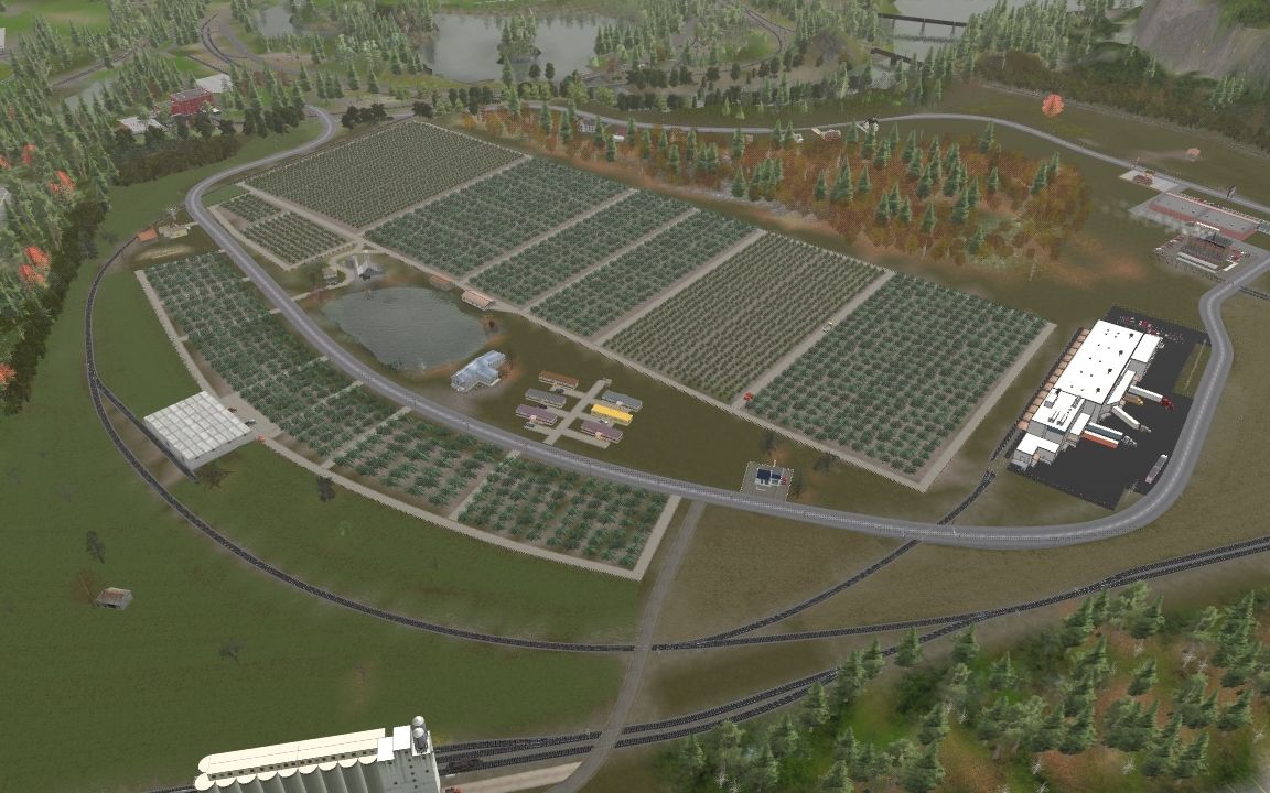
Work in progress on the Michigan Southern. I'm modeling the MSO as it was in the summer of 2010.

Above White Pigeon, MI. The track curving to the right leads to PRM Trucking (aggregates) and Tracy Imports (logs). The track curving left is the White Pigeon Paper lead.


This view is to the left of the above, showing White Pigeon Paper. The paper mill is right on the bank of the Pigeon River, which is where the edge of the scenicked area is at the moment.


Approaching Sturgis, MI from White Pigeon in the west, the line passes Penguin Plastics, which is set back a bit, towards West Chicago Rd.


The line crosses Broadus Street just past Penguin Plastics. You can see International Paper in the background, and there's lots of scenic work to be done.


Here are some views of the wye at Sturgis, with International Paper on the northwest side of the crossing.


The line crossing the MSO main is the old GR&I that runs from Abbott Labs' baby food factory just out of frame to the north and goes south about 2 3/4 miles, past a now-defunct scrap yard to serve a single customer near the Indiana state line.

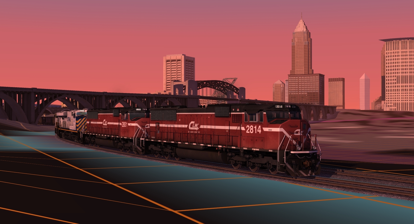
The MSO interchanges in White Pigeon with the Grand Elk Railway, part of the Watco holdings. The GDLK local from Kalamazoo shoves a cut of cars across Rt 131 onto the Michigan Southern three times a week. Here's what that looks like with the scenery partially done:


The chop-nose GP9 is from Jointed Rail on commission, and the WAMX GP40s are available from RRMods.
 
Back
Top