LV - The Forks of the Delaware

Status
Not open for further replies.
lv_continue_Delaware River

Continuing on.......at the signal tower

1_877.jpg


and approaching the bridge......the CNJ's bridge to the right
1_879.jpg


crossing the Pennsy's Bel-Del branch
1_881.jpg


The Bel-Del,with the PRR Phillipsburg, NJ station in background
1_883.jpg


onto the Delaware River bridge........the CNJ's Phillipsburg, NJ station in background
1_885.jpg


across the Delaware...the "Connector Bridge" in background was used chiefly by the Lehigh & Hudson River Railroad, the Jersey Central, and the Delaware, Lackawanna & Western RR
1_888.jpg


Over the Delaware River.....
1_891.jpg


crossing over the Delaware Canal.....
1_892.jpg


and over Delaware River Drive......Rt. 611
1_893.jpg


Arriving on Pennsylvania turf at Mt. Ida
1_895.jpg


Last edited:
lv_continue_Jersey St neighborhood

Continuing west along the neighborhoods......

1_859.jpg


1_862.jpg


1_863.jpg


1_864.jpg


1_866.jpg


peering up Jersey St, we see the church at the So. Main St.
1_869.jpg


1_868.jpg


1_865.jpg


The cross-over with the Bel-Del cutoff just ahead
1_872.jpg


approaching the diamonds...the cut thru Mt Mendi in background.
1_875.jpg

 
Last edited:
lv_continue_Fox St neighborhood

Still traveling thru the neighborhoods behind Mercer St.......crossing at Fox St.

1_849.jpg


1_851.jpg


1_852.jpg


1_854.jpg


1_857.jpg


1_858.jpg


1_860.jpg

Hopefully, did not rattle too many windows!
 
Last edited:
lv_continue_Jefferson St neighborhood

A short distance further along......arriving at Jefferson St crossing

1_829.jpg


1_831.jpg


1_826.jpg


Just watching the trains roll by from the front porch chair
1_833.jpg


1_836.jpg


cruise thru the neighborhood behind Mercer St
1_838.jpg


1_839.jpg


1_843.jpg


1_848.jpg


Reaching the Stockton St. crossing........the CNJ & Lackawanna bridges over Stockton St. in the distance.
1_845.jpg


Stockton St would be a railfan's dream come true........you could catch Lackawanna consists and Erie locos on the upper bridge (as shown in earlier postings)......
see CNJ and Reading RR action on the lower bridge (also depicted earlier)...
and then walk a few short blocks sosuth from So. Main St, to catch the Lehigh Valley trains too.
What's more.......if you continue south of this location a couple blocks.....you'd be overlooking the Pennsy's Bel-Del yard. All from just one city street!

 
Last edited:
lv_East -to -West

OK, this should be the last photo update for "Phase 1" of my route.
Lots of pics.......because it is my favorite stretch of trackage for this area.

At the eastern end of Phillipsburg, NJ.........the Lehigh Valley enters town at the McKeen St. crossing
1_809.jpg
and heads west thru the neighborhoods behind Mercer St.
1_805.jpg


1_803.jpg


1_809.jpg


At the head end is RS3 #213
1_810.jpg


1_812.jpg


backed-up by RS3 #218
1_816.jpg


1_817.jpg


1_818.jpg

rumbling thru the neighborhood and adding a nice layer of diesel soot to Mrs. Miller's laundry
approaching the Jefferson St. crossing.
 
Last edited:
Nope, I don't think that this is the Reading Line, but I could be wrong.

By the way, the Reading Line is just what the NS division is called, not just the layout.
 
To cascaderailroad

May not be a flaw, in those days locomotive headlights weren't turned on in the daytime. Considering the captured era in these wonderful shots I think its appropriate the headlights are off.
 
Nope, I don't think that this is the Reading Line, but I could be wrong.

By the way, the Reading Line is just what the NS division is called, not just the layout.

that route only has a small section of this line. but obviously that route is modern day and this one is cerka 1950s about.
 
Future Plans

Just thought might be good idea to outline my future plans with this route - may help clarify and answer some of your questions in the process.
_________________________________________________


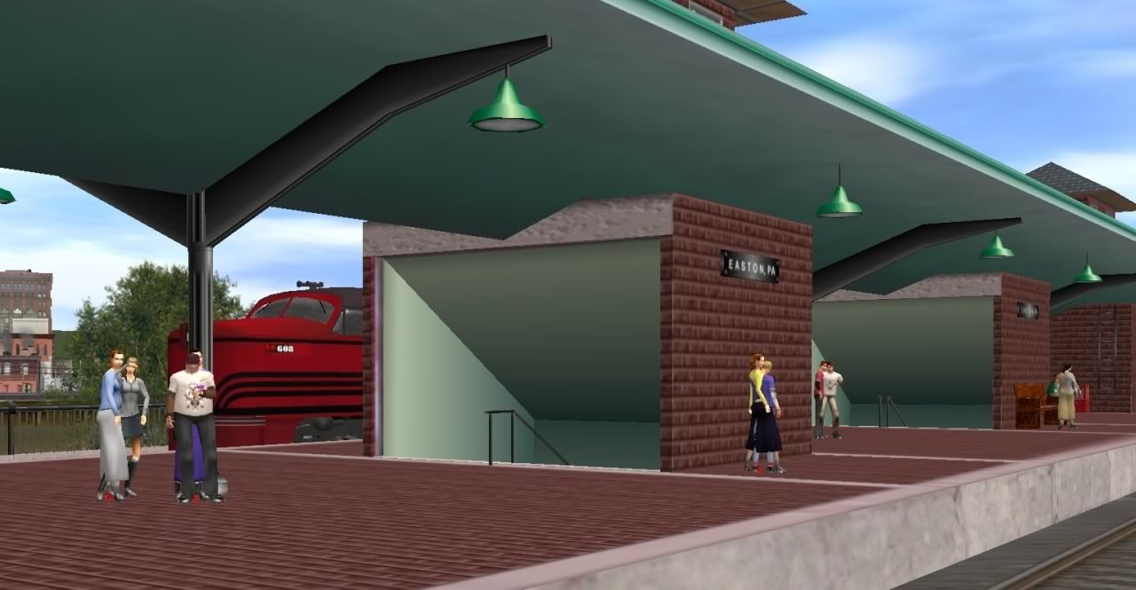
As stated in my opening posting, the route is (or will be) centered around the Easton, Pa - Phillipsburg, NJ area............indicating that I hope to expand things.........most likely, in ALL directions.

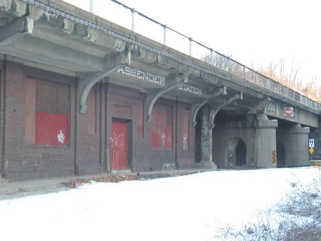
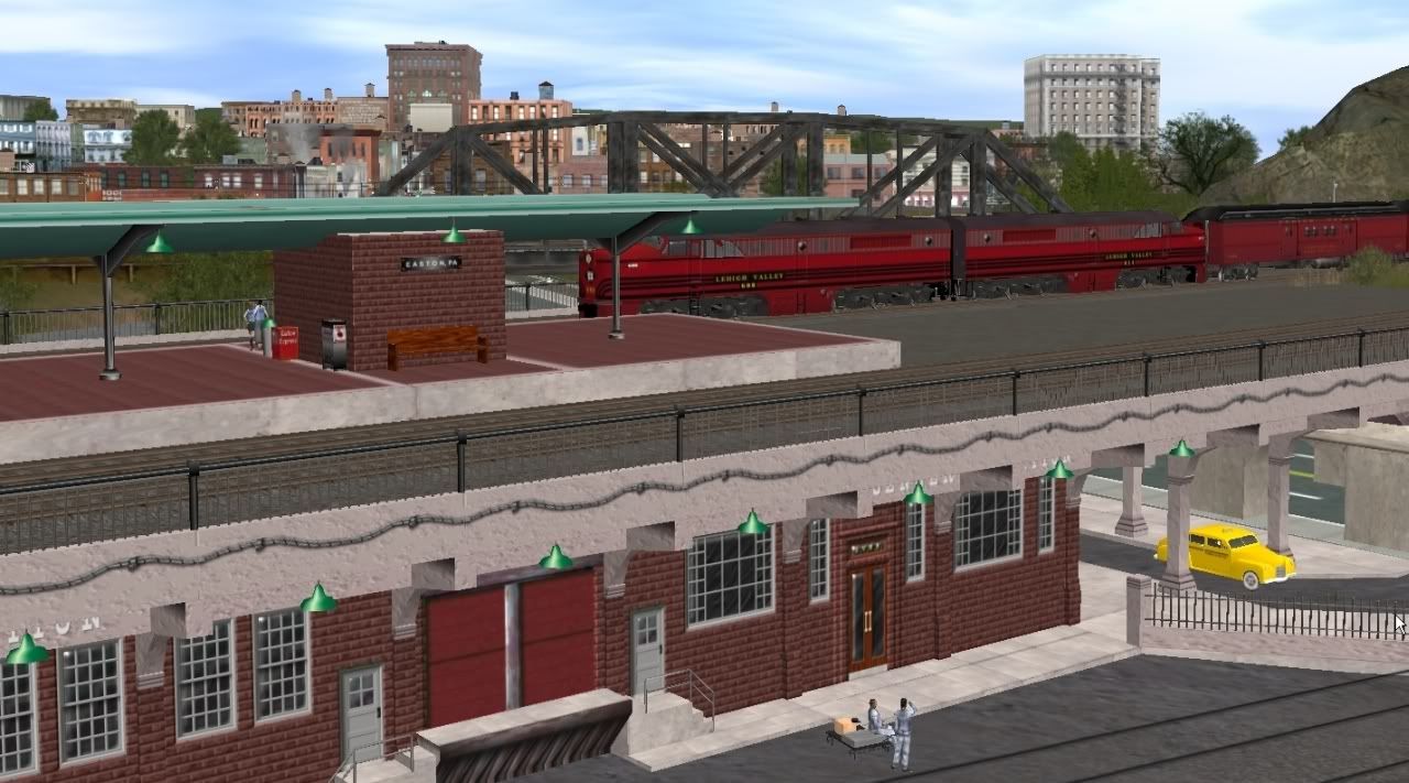
Everything pictured so far all takes place in a small area....less than 10 miles from east-to-west......but, as you can see, there is a lot going on in that small area......which is what makes it a fun area to reproduce.
However, you could drive that distance, even at restricted speed, in just a few minutes; and only a few of the industries are involved so far - none of them being the major industries of the area. So, things are not really ready yet - from an OPERATIONAL point-of-view.

so....the expansion plans (in no order of importance) are:
1. WEST: when you talk of the Lehigh Valley in this area, you are also talking Bethlehem Steel.
So, obviously, need to extend west out to the Bethlehem, Allentown area.........original plan is to go out to Macungie and Alburtis.( this will provide me good connection with trains from Reading, and allow me to include the Mack Truck plant}.

2. EAST: will be going eastward definately as far as Blommsbury area.......I want to be able to include the Musconnetcong Tunnel for sure........maybe use it as an IPortal.

3. NORTH: Nearly all the "action" on the Lehigh Valley takes place north of where I am at now.
The North Branch, which I have shown so far, barely scratches the surface.
There are major cement plants, Nazareth, Stockerton, Martin's Creek. Several major industries through Wilson Borough area.
And there is the "Slate Belt" - Bangor, Pen Argyl, Roseto.
Aside from the coal industries and Bethlehem Steel - these other industries provided a HUGE amount of traffic for the area railroads.
To the north and northwest, also allows inclusion of additional railroads........besides connections with the Erie, and the Lackawanna, there are the Lehigh & New England, Bath, and Ironton railroads.

Also to the north in New Jersey.......will continue the Bel-Del up thru Belvidere, hopefully as far as Portland.......providing further connections for Lehigh & Hudson River, Lackawanna, Erie traffic, and northeast thru Washington, NJ and Hackettstown, NJ.

4. SOUTH: Logical extension southward from Bethlehem Steel into Hellertown/Saucon Valley includes their coke plants and Saucon yards....will probably go as far south as Quakertown to include Reading commuter traffic as well.
Southwest of there, thru the Emmaus area also provides some interesting operations.
South in NJ, hope to get as far as the Riegel Ridge area, for the paper mill there, and into Fleminton....and take the Bel-Del down to the Milford - Frenchtown area (yes, Dylan - across the bridge from your backyard! LOL).

OK - so all this is pretty ambitious (probably overly-ambitious), but you have to start with a plan, and see what happens.

Having said all that............should be obvious this route is in no way ready yet for release/upload......and I would not even guess when it might be ready. (Hey, I'm an old fart who works slowly........and this is jsut a hobby for me, so not on any sort of time schedule).

So........will get back to work........."Phase 2" awaits me.

Regards,
Mark
p.s., ..........if you have screenshots which relate to this theme, feel free to post them here too.


p.s., ..........if you have screenshots which relate to this theme, feel free to post them here too.


i got one.

in this pic
http://i484.photobucket.com/albums/rr209/Kree8tiviT/p1_lv/1_883.jpg

there's no curve like that. it's like a straight track in not a slight curve but nothing like that curve.

0650a105c4fc432e8c2a9a3a02fa1b46.jpg


P.S. I'm working from Belvidere to Trenton with the branch from Lamertville to fleminton. Want to possibly join up and create 1 big massive PRR/LV route? I'm also doing custom track side buildings. I'm also working with the BDRV railway for help with accuracy and working with them on the re-build of the Riegallsville Train station that burnt down in about 1969 i think. I can help with small details like above that will make or break a great route like this.

BTW may i see what u got done of the massive PRR freight yard in philupburg?
here it is in 1956
2f248eff7ae63dfdde99407b00a253ff.jpg

and 2002
540b8d630698dce5351d10f8127a38b9.jpg

every track except 3 have been torn up one it being used one is being used as the main line for BDRV one is abandoned and completely separated from the main line. and one is being used as a siding for a lumber warehouse down the tracks a bit out of frame.
 
THAT IS ONE AMAZING LOOKING ROUTE!!!!!! :Y:


WOW!!!!!!!!!!! :udrool: :mop:

KEEP UP THE GOOD WORK!!!!!!!!!!!!!!!!!! :Y: :clap:
 
some of your questions

Try to answer a few questions:

Dylanviey:
Where did u get those spools that are on the back of my F22 flat cars?
The spools are on DLS from Maddy25........she does great work, and I use a lot of her creations - and, most importantly, most everything she makes actually WORKS as intended - so hats-off to her.

Sampug394:
I'm just wondering; Has any Made/Reskinned any Steam Locomotives for the Lehigh
I am not aware of any LV steam on the DLS or elsewhere........however;
I made a "Pacific" for the LV quite a few years ago......eventually, I will dust-off those files and update them

gfisher:
And I just have to ask, where did you get the buicks and oldsmobiles?
Jadebullet:
What is the KUID on those fantastic looking 1950s cars.
The cars are one my projects, and I have not uploaded them to DLS, so you will not find a kuid# for them yet.
As seen, I have only done a few......a bunch more I want to make......will probably upload once I have enough to make logical "packages" of them.

cascaderailroad:
I especially am interested in the trees, bushs, grass, and I am asking, is this a Trainz 2009 route ?
The majority of vegetation used is "Trunda's".....I think he did fantastic job, and so I use it extensively.
I am working in TRZ2006 version. 2009 would be great for it's ability to work in terrain grids of 5m instead 10m.........unfortunately, from all the comments I've read here, sounds as if it still had far too many "issues" of things not working right.


Dylanviey:
the Easton train station (and I'm only stating this out becasue it looks like a custom built train station) the platform dosen't extent far enough to the east
Depends on the year ......yes, correct, initially it extended closer to the the entrance to Mt. Ida. As time went on, parts were either dismantled, or fell down - which would not susrprise me since that "Gull Wing" roof design is sort of impracticle in area that receives snow fall.
Also......I originally designed this model for use in MSTS......and MSTS does not use "splines" for laying track......fixed track segments only, and fixed radius curves.....following these fixed curves would have made the structure look awkward and incorrect......so compromised.

Dylanviey:
I'm also questioning about weather the station was brick red, or yellowish color as how it is now.
Yellow!?!? Not in the 40 years that I lived in Easton.
Here's a photo...I took personally.......maybe about 5 years ago:


eastonLVterm05.jpg


1_064.jpg

it's red brick

Dylanviey:
also i don't think the eastom train station had a brick patio style platform

Not sure if this photo clear enough to help you.......
eastonLVtermyardend.jpg


1_911.jpg

1_071.jpg


Dylanviey:
I've been studying satellite photographs of the whole line from 1956 and 1963.
They had satellite imagery in 1956?? Jeez.......we didn't even have an electric can opener then, and the TV was still black & white! LOL

Dylanviey:
That warehouse was a 1 track curved warehouse. not a 2 track. but that may just be nitpicking
I cannot help you there, on a factual basis......as I don't remember from personal experience, and have not found any reference depicting.

Using these photos.....I made certain "assumptions" :
Taken after the structure suffered a fire:
cnjStafreight01.jpg


cnjFrt03.jpg

In that first photo, you can look thru the curved shed doors....to the other side of building, where you see it also had similar shed doors.

cnjStafreight02.jpg


cnjFrt01.jpg

and in the second photo......not only do you see opening for shed doors on other side of building......to the right there is that "drive-thru" area.

So taking those things into consideration......I assumed there is a similar track on other side........would only be logical.


Dylanviey:
I don't think there was ever a track there below that train station.
Yes, was definitely track there........I could not find my photo of it, that I personally took, ......but, down on Lehigh Drive, against the bank below the freight shed, and just before the road crossing.......there was an old "coaling station" for truck loading - constructed of timbers (I photographed, with future intentions of modelling it). The chutes were labeled "pea, hard, etc"
cnjCoal01.jpg

Actually, you crossed the track twice here........but I cheated because of the limitations in what you can create terrain-wise.
To the left, track went to small service area......located near the Crowder Elecrical contractor's building....and an area now used by the Lafayette College rowing team.


Thanks again for your comments and encouragement!
Regards,
Mark
 
Kree8tiviT said:

Using these photos.....I made certain "assumptions" :
Taken after the structure suffered a fire:
[snip]

[snip]
In that first photo, you can look thru the curved shed doors....to the other side of building, where you see it also had similar shed doors.

[snip]

[snip]
and in the second photo......not only do you see opening for shed doors on other side of building......to the right there is that "drive-thru" area.

So taking those things into consideration......I assumed there is a similar track on other side........would only be logical.


o u made a custom model for it? well i hate to say but the shape is wrong. it was curved and very different from most warehouses you think about. From the aerial photo i appear to be wrong. it appears it was 2 track but both tracks where on the same side of the building it appears. The other side was used for loading trucks.
f894c07e552fb3ea604928575b883c98.jpg


Also i stand corrected on the color (damn faulty memory) but may i suggest using the texture from your warehouse? That will look a lot better.

Also as you can see the platform was almost twice as long. You can still see the platforum from Google earth. if you look close enough.

Kree8tiviT said:
South in NJ, hope to get as far as the Riegel Ridge area, for the paper mill there, and into Fleminton....and take the Bel-Del down to the Milford - Frenchtown area (yes, Dylan - across the bridge from your backyard! LOL).

Do i know you??? i REALLY don't' remember posting on any public forum about be living near Milford or Frenchtown. or did u hear about that via word of mouth? Or did we strike up a convo while i was over at BDRV doing research?

Also do u know of any photos of this area and the BDRV from about the 1970's and back? I've been looking for as many reference photos as i could.

Kree8tiviT said:
Yes, was definitely track there........I could not find my photo of it, that I personally took, ......but, down on Lehigh Drive, against the bank below the freight shed, and just before the road crossing.......there was an old "coaling station" for truck loading - constructed of timbers (I photographed, with future intentions of modelling it). The chutes were labeled "pea, hard, etc"
[snip]
Actually, you crossed the track twice here........but I cheated because of the limitations in what you can create terrain-wise.
To the left, track went to small service area......located near the Crowder Elecrical contractor's building....and an area now used by the Lafayette College rowing team.


Thanks again for your comments and encouragement!
Regards,
Mark

I see the track now that i took a closer look at the 1956 photo of the area.
 
Last edited:
Very nice job, Mark.

When I saw your first "photo" looking at the CNJ bridge from the LV side, I got a flashback. I ate at the McDonalds down there on 611 next to the old CNJ bridge about 20 years ago. Instead of driving down the pike and 76 to Philidelphia, my dad and I would head across 84 to 6 at Milford then down 611 through the Gap. This made for a much more interesting ride and a much less hectic one at that. We stopped a couple of times at the McDonalds there, and I recall seeing a very short Conrail freight heading west on the LV line past the station.

I look forward to seeing more pictures in the future. Keep up the good work and take your time!

John
 

Actually, you crossed the track twice here........but I cheated because of the limitations in what you can create terrain-wise.
To the left, track went to small service area......located near the Crowder Elecrical contractor's building....and an area now used by the Lafayette College rowing team.

If you really want to do detail you could make a ground spline or object that's a higher poly than place it how you want. I was planing on doing that for the railroad south of Lamertfiville since the right of way was planed right on the old tow path of the canal.
 
Status
Not open for further replies.
Back
Top