Railroading on the cheap an elegant solution for a depot.

JCitron

Trainzing since 12-2003
The New York and Greenwood Lake Railway disappeared in the late 1920s due to reservoir being built across a major part of its ROW. The railroad its self at one point became a subsidiary of the Erie Railroad who operated the railroad on the cheap with light rails and older equipment. At the moment I'm working on a project to bring the route back to life with a bit of artistic license and what ifs since so much is gone. During the research phase, a friend of mine for whom I'm making the route for, has been digging through some photos that belonged to is grandfather who worked for the NYGWL Rwy. and later the Erie.

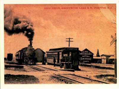
Among these fabulously fascinating photos, is this station down at Pompton, NJ where the line crossed the New York Susquehanna and Western, also an Erie subsidiary at the time. Today, Pompton Jct. still exists and still pretty much intact. The line north ends about 1/2 mile past the jct. and serves as a small spur to serve a junk yard. The line south ends a bit down towards Pompton Lakes as a spur. This line has been mothballed, and will probably be turned into a rail trail, but hopefully not.

Anyway, here's the Pompton jct. station.
Pompton station.jpg

Yes, the station is an old passenger car with a door cut into the side of it. How cool is that! The Erie steam locomotive is something as well.
 
JCitron,

Nothing beats having a great Back Story,

Looking forward to see how it comes out under your new leadership......:)

Thank you John for contribution!
 
Better than a boxcar on the ground! Good luck with the route!

Agreed. I never thought of using a passenger car like that. It gives me some ideas of other routes where I can do something like that.

JCitron,

Nothing beats having a great Back Story,

Looking forward to see how it comes out under your new leadership......:)

Thank you John for contribution!

You're welcome Blue.

The route catered its self to the tourists up at Greenwood Lake to the north as the line followed the picturesque Wanaque Valley. The company also served some other industry, lumber operations, and iron mining in the south, but once the Wanaque Valley was flooded the second time, that ended the railroad completely. The route terminated in Sterling Forest, NY right on the NY/NJ border after serving a few other towns along the way. As far as towns go, they were only hamlets with a few houses except for Awosting, NJ which is the largest not counting the bigger ones in the far south. In Sterling Forest, NY, there was a grand hotel and ferry as well as lots of summer homes and other homes for people to spend their summer vacations at. The ferry used to serve Greenwood Lake, NY proper and a big waterside hotel once located there. My friend lives in that area down the street from where the hotel used to be. His neighborhood was built in the early 1920s.

At the moment, I'm spotting important details in various locations that my friend provided pictures for. The most difficult has been the ferry and hotel. That location has been completely erased from the world. There's not even a trace of anything there that indicated there was once a railroad. Using the hills on the far shore as landmarks, I've been able to figure out where the station might be. Locating other stations too has been a bit tricky because there's no signs of them today on Google Earth. Photos, landmarks, and landscape are my only guides. Last night I made great progress and now I'm fitting in the turntable, engine house and 3-track yard along the shore near the hotel.

What I've found interesting with the project is how stuff comes together. Once I figured out where a landmark is, other details fit right in around it like a puzzle piece. I lucked out with the 1948 topo map I'm using because it including the height information in those locations where the landscape was flooded. That too has been the same. I had to climb from 100 meters to 189 meters while following the river and the valley. Magically, the grade worked its self out and the line climbs smoothly and easily along the river's edge.

When I get some in-progress screenshots, I'll post them up in the Surveyor's forum.
 
Back
Top