Trying to get DEM for my new route and following the tutorial #8 which says to use the Cdn Geogratis which has a link that now points to a dead page. Has anyone who uses Transderm been able to get DEMs for their routes lately? There is no track in the area, I just want the DEM so the hills and such are correct. The link worked back in 2016 but not now.
Install the app
How to install the app on iOS
Follow along with the video below to see how to install our site as a web app on your home screen.
Note: This feature may not be available in some browsers.
You are using an out of date browser. It may not display this or other websites correctly.
You should upgrade or use an alternative browser.
You should upgrade or use an alternative browser.
Getting DEM for Transderm in 2018?
- Thread starter Chris750
- Start date
Have you tried the Internet Archive www.archive.org?
You might have access to their downloads there.
I have brought in TransDem created routes during the beta but not after release so I can't help you with that. People have been reporting "problems", but nothing specific, which would be helpful to know.
You might have access to their downloads there.
I have brought in TransDem created routes during the beta but not after release so I can't help you with that. People have been reporting "problems", but nothing specific, which would be helpful to know.
Trying to get DEM for my new route and following the tutorial #8 which says to use the Cdn Geogratis which has a link that now points to a dead page. Has anyone who uses Transderm been able to get DEMs for their routes lately? There is no track in the area, I just want the DEM so the hills and such are correct. The link worked back in 2016 but not now.
The Canadian Open Data site is not the easiest to navigate. But the 0.75 arc sec DEM is still there.
Top page "Canadian Digital Elevation Model"
https://open.canada.ca/data/en/dataset/7f245e4d-76c2-4caa-951a-45d1d2051333
Specs (Data is now in GeoTIFF format):
http://ftp.geogratis.gc.ca/pub/nrcan_rncan/elevation/cdem_mnec/doc/CDEM_product_specs.pdf
Product index as KML file (to use with Google Earth)
http://ftp.geogratis.gc.ca/pub/nrcan_rncan/elevation/cdem_mnec/index/cdem_index_250k.kml
Direct download (organized by index):
http://ftp.geogratis.gc.ca/pub/nrcan_rncan/elevation/cdem_mnec/
I had all those links, but it is impossible to figure out what to do. Every time I manage to get a geotiff it is just a black square. The tutorial #8 has to be re-written if you still wish to use the Cdn Geocite.
From what I understand in order to view a KML file you need earth google, and in order to access that you need chrome, which I am not going to install. Is the Cdn site the only place that has DEM files that work in transderm?
**Ok, the black square was due to my program, although it said it supported TIF it doesn't, downloaded an actual TIFF viewer and now I see stuff. Now to figure out how to get it into transderm**
Last edited:
Ok, this is how you get it to work now:
[SIZE=+1] http://ftp.geogratis.gc.ca/pub/nrcan_rncan/vector/index/html/geospatial_product_index_en.html#link
[/SIZE]
[SIZE=+1]You zoom in to the area you want, click on THEMES and then ARCHIVED DATA, GEOBASE CDED 1:50,000. It then gives a zip file with DEM in it on the left, save the zip file(s) and then open them in TRANSDERM one at a time, convert to needed meter size and save. Then open the new converted files to form a full DEM which can then be exported to TRAINZ.
[/SIZE]
No need to go to archived data. The new GeoTIFFs are just fine. TransDEM will open them out of the box. And you get bigger chunks, too. One new GeoTIFF covers the same area as 16(!) of the older CDED downloads (and, furthermore, each CDED DEM was split into two separate files.) If you still need to stitch two or more of those larger GeoTIFF DEMs together, with the latest TransDEM version you can select multiple (adjacent) files when opening a DEM, and TransDEM will merge them all (provided your machine has enough memory).
The Canadian map indexing system hasn't changed. For the pre-packaged data you always needed the index. Until recently, you had to download an index map. Nowadays they provide it as KML/KMZ vector overlay, but the information is still the same. For the GeoTIFFs you only need the 250k index, not the 50k index any longer.
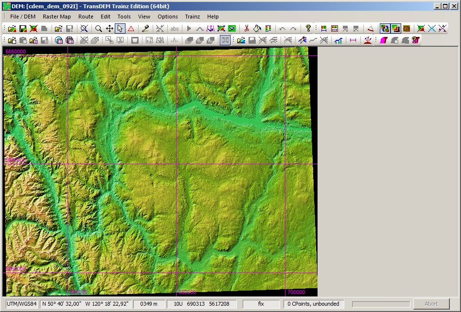
For example, Kamloops, BC, lies in map sheet 092I in the 250k index and in sheet 092I09 in the 50k index.
The Canadian map indexing system hasn't changed. For the pre-packaged data you always needed the index. Until recently, you had to download an index map. Nowadays they provide it as KML/KMZ vector overlay, but the information is still the same. For the GeoTIFFs you only need the 250k index, not the 50k index any longer.
For example, Kamloops, BC, lies in map sheet 092I in the 250k index and in sheet 092I09 in the 50k index.
No need to go to archived data. The new GeoTIFFs are just fine. TransDEM will open them out of the box. And you get bigger chunks, too. One new GeoTIFF covers the same area as 16(!) of the older CDED downloads (and, furthermore, each CDED DEM was split into two separate files.) If you still need to stitch two or more of those larger GeoTIFF DEMs together, with the latest TransDEM version you can select multiple (adjacent) files when opening a DEM, and TransDEM will merge them all (provided your machine has enough memory).
The Canadian map indexing system hasn't changed. For the pre-packaged data you always needed the index. Until recently, you had to download an index map. Nowadays they provide it as KML/KMZ vector overlay, but the information is still the same. For the GeoTIFFs you only need the 250k index, not the 50k index any longer.
For example, Kamloops, BC, lies in map sheet 092I in the 250k index and in sheet 092I09 in the 50k index.
So how is it done then? I spent about 5 hours yesterday trying to figure it out and then contacted you. At least the link above is dirt simple, zoom to your area and save the zip file, open in transdem and then save.
Everytime I tried I either went around in circles or ended up with a black map.
So how is it done then? I spent about 5 hours yesterday trying to figure it out and then contacted you. At least the link above is dirt simple, zoom to your area and save the zip file, open in transdem and then save.
Download the the product index, a KML file (see previous post):
http://ftp.geogratis.gc.ca/pub/nrcan_rncan/elevation/cdem_mnec/index/cdem_index_250k.kml
Open it with Google Earth. Zoom to your area. Take a note of the index identifier, a text label within the yellow rectangle, e.g. 092I for Kamloops, BC.
Open (see previous post):
http://ftp.geogratis.gc.ca/pub/nrcan_rncan/elevation/cdem_mnec/
Scroll down to the 092 folder and open it.
Select "cdem_dem_092I_tif.zip" and download. Unpack and open the .tif file in TransDEM as a DEM.
Ok, this is how you get it to work now:
http://ftp.geogratis.gc.ca/pub/nrcan_rncan/vector/index/html/geospatial_product_index_en.html#link
This will lead to the very same results, and it is a more direct way
 . But do not go to Archived Data, pick Elevation | Canadian Digital Elevation Model (CDEM) instead.
Download the the product index, a KML file (see previous post):
http://ftp.geogratis.gc.ca/pub/nrcan_rncan/elevation/cdem_mnec/index/cdem_index_250k.kml
Open it with Google Earth. Zoom to your area. Take a note of the index identifier, a text label within the yellow rectangle, e.g. 092I for Kamloops, BC.
Open (see previous post):
http://ftp.geogratis.gc.ca/pub/nrcan_rncan/elevation/cdem_mnec/
Scroll down to the 092 folder and open it.
Select "cdem_dem_092I_tif.zip" and download. Unpack and open the .tif file in TransDEM as a DEM.
Well there is the problem, I do not have google earth and will never have it as to use it now you need chrome. The way I stated is working just fine in my layout and you don't need google earth.
cascaderailroad
New member
Well there is the problem, I do not have google earth and will never have it as to use it now you need chrome. The way I stated is working just fine in my layout and you don't need google earth.
So how is it done then? I spent about 5 hours yesterday trying to figure it out and then contacted you. At least the link above is dirt simple, zoom to your area and save the zip file, open in transdem and then save.
Everytime I tried I either went around in circles or ended up with a black map.
Doesn't sound like it is working just fine in your layout
Google Earth is fantastic, and operates in Opera, which is a fantastic well known browser
If you are using IE (Internet Explorer), it is just about on the way out, ending update support
I have Firefox Browser and Chrome Browser, but Opera Browser is the best !
Last edited:
Dinorius_Redundicus
kuid 68213
“Transderm”......a good name for a re-skin program?
...a good name for a re-skin program?cascaderailroad -
Check it out - it is faster than most; Standards-based, and has some amazing, unmatched features & capabilities.
A vast improvement over Internet Explorer.
It depends on what you need your browser to do - I have them all, but my default is the new Microsoft Edge in Windows 10.I have Firefox Browser and Chrome Browser, but Opera Browser is the best !
Check it out - it is faster than most; Standards-based, and has some amazing, unmatched features & capabilities.
A vast improvement over Internet Explorer.
Similar threads
- Replies
- 7
- Views
- 413
- Replies
- 1
- Views
- 360
- Replies
- 18
- Views
- 1K