Microsoft Earth

HSSRAIL

New member
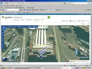
Trainzers I have found a map service that gives birds eye views that are detailed enough to tell what kind of buildings are in a given location. The service is Microsoft Earth as long as you don't use for commercial purposes this is free.

http://maps.live.com

Click on a locality than click on birdseye view this is awesome.

Howard
 
I wonder if you could help a wee bit further? Used the link but it takes me to a Download of IE7?? Where exactly is "Earth" if if am not being too silly?
 
That link should have taken you to live search map. This looks like a web search engine it is not. This is not a web search on the very top line that ends in a green magnifying glass this is the Microsoft Earth Map search Engine. Put in a US City than click search the magnifying glass. After doing that look at the left hand side of your screen you should see your city, click on that selection than go over to the right where the mag grid is look at the top and select birds eye view.
 
Last edited:
Hi Bob,

I think you have to have a program called Microsoft Virtual Earth for it to work. The latest version of the program is version 3D beta and it is not much good for places outside USA.

Cheers,
Bill69
 
Microsoft earth

Is a great tool. It works in many parts of Austria, i.e. in Innsbruck where I live. The images are about a half year old. In the highest resolution 1 pixel equals 20 cm - 5 pixels are 1 meter (same as Google but the newer images just look better). Thus 720 meters (1 Trainz board) is a picture of 3600 x 3600 pixels. The birds eye view is fantastic giving a pseudo 3D effect.
 
Well I still prefer Google earth. Pics below from Microsoft Virtual Earth and from Google Earth.

WellingtonNZ.jpg


WellingtonNZgoogle.jpg


Cheers,
Bill69
 
I prefer Google Earth because of the user photos, the quality ofthe photo's the 3D view, The 3D flight sim inbuilt and the street view which put to gether creates a brilliant picture of the landscape.

phil
________
VAPORIZER WIKI
 
Last edited:
I personally use http://www.flashearth.com/ for all of my virtual viewing needs, as it uses lots of different companies and sites to create maps. The best one is Microsoft VE with labels.

FlashEarth is simply a gateway. A number of providers for maps and imagery adhere to a near-standard often called Map Tiles. Technically speaking these providers refer to the world in a standard ellipsoidal Mercator (map) projection, based on WGS84, and subdivide the world into a huge number of small 256 x 256 pixel squares, at up to 22 zoom levels. This subdividing is called a quadtree. Sounds complicated, but makes it very easy for FlashEarth to access the data of those providers.

Google Maps, Microsoft Virtual Earth (maps.live.com for end users), Yahoo Maps and Open Street Map all use this same standard, for ortho-imagery (those shot from a vertical perspective), for maps, and also for oblique but static viewing angles as with Virtual Earth Bird's Eye View.

Big advantage of this approach: Instant absolute geographic coordinates.

(One of the reasons, why I implemented a map tile client for TransDEM last year.)
 
The 2-D maps are available on the net without downloading anything, but the resolution isn't as good as Google Maps.
Google earth gives you all the info iyou need, including elevations.

:cool: Claude
 
...One of the reasons, why I implemented a map tile client for TransDEM last year...
Being able to use pics from Google Earth placed as UTM tiles in TRS is a brilliant facility of TransDEM that all serious Trainzers should consider using IMO. :)
 
I, as a norwegian, use a site called http://norgeibilder.no/ (norge i bilder/norway in pictures).
A lot better than both google and MS maps... :-)

Lets face it, norway is not, by any standard, center of the earth and both MS og google haven't good pics of norway coz of that. We are the corner of the world so to speak.. :D

So to the other norwegians here (if any...) the http://norgeibilder.no/ is the maps to use

:D
 
Hi Spidair,

Thank you for that link, cool to see a image actually showing the buildings on this property where I'm stuck. :)

That page in the link seems a little unstable on my computer, but I can live with it.

Linda
 
Just an FYI; maps.ask.com uses the local.live maps but allows you to link to a specific location and doesn't require addons (except for java and flash)

peter
 
I was everywhere, last night...

:cool: Microsoft Virtual Earth, is cool, you can get right down on top of the Birds Eye View, and all the wimpy bridges suddenly are straightened.

Make sure on each location you study, that you use the rotation keys, because usually there are four separate views of the location.

This means the train your looking at, may not be there in the next rotation of the view...but then that view may give details presented on another day.

You can go into road map view, and using the Ctrl+left mouse button, plane the view back, and see the ground profile.

Google Earth, now has a lot of content builders using Google Sketch-up, and loads a lot of megs.

But NASA World Wind, is the only one of the three, that uses Topo maps.
 
Back
Top