merging dems with microdem

Gary25b

Member
I have attemtped to follow a couple of the dem to gnd tutorials found here in the forums. One thing I'm having trouble with:

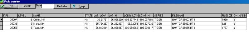
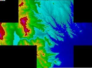
I have 10 dem files that I got off the USGS site, and wanted to use them all pieced together for my route. So I merged the dems in microdem, to create one big dem, of irregular shape (I mean not rectangular).

demimage.jpg


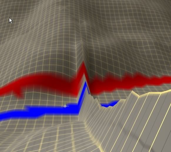
When converting that to the gnd file using hog, and then putting into Trainz, I get wildly exagerated terrain. Is that because of the black space around the edges? Does the merged dem file have to be somehow cropped?

Second question, should I instead of merging, just create individual rectangular gnd files? And then merge in Trainz?

third question: what is the grid size for 2010? The tutorials talk about a 10 meter grid.

Thanks for any help.
 
Last edited:
Judging by the screenshot you have merged the DEMs correctly. Yes you should merge them and create one large route, not many small ones.

Did you overlay the DEM with TIGER data? HOG uses tiger to filter the route size so the 'black' areas should be irrelevant.

There are known issues in TRS09 with HOG created terrain, I don't have 10 but I assume the same issues may apply. If your irregular terrain is along baseboard joins there is a sticky in the TRS09 forum regarding importing HOG routes which may help.

OTOH if your irregular terrain is spread uniformly across the map there is something else amiss...

Andy :)
 
I have been unable to get the Tiger data to overlay. With the complete merged DEMs microdem says it has insufficient memory, when I try to do individual dems to overlay Tiger data, microdem just sits there, no response.

I'll look for that sticky you mentioned.
 
Without the Tiger overlay saved HOG has no means by which to filter the route-creation process, so i suspect the error lies there. I have run out of memory overlaying Tiger after merging about 50 quads, but you should be fine merging 10. Which version of MicroDem are you using?

A couple of other things that might be an issue:

1. Are all your quads have to be either 10 meter resolution or 30 meter resolution - you must convert one or other if you have a mixture,

2. Are all your quads from the same UTM zone?

Andy...

A
 
Hi, yes they are all 10 meter quads, and all are from UTM zone 13. My microdem is rev 2010.1.10.1

When I have gotten the Tiger data, it comes by county. Three different counties cover the area of the quads. I have placed the county Tiger data in c:mapdata/tiger/nm. Microdem never asks where they are, so I hope I have them in the proper folder.

I have the Tiger line data but did not get any shape files. There was no indication in the tutorials about getting shape files.
 
Last edited:
I note that when I go to Microdem and try to simply open one of the Tiger County files, I get an error: missing tiger-index.dbf. Perhaps that is my problem in doing overlays.

[later] so I reinstalled Microdem, and now have the tiger-index.dbf. I can now open a county file, but it is just blank. Nothing shows in microdem. The files (still zipped) are there, and seen by Microdem, but not displayed.

Here's a screenshot of the files available to Microdem, in the Microdem index dbf I guess:

ScreenHunter_01Feb141146.jpg
 
Last edited:
in the continuing saga:

although the Microdem documentation says to leave the Tiger Line files zipped, in the help files it also says you can unzip them. So I did, and now the Tiger lines properly overlay the terrain.

One more question: there are many varieties of shape files per county. Are the shape files needed? useful? alternative to the regular line file?
 
Glad you have it working. I have never unzipped the files, nor seen the screen in your shot, so we must be arriving at the same place via a different route. Tiger Line Files are all you need...

Andy :)
 
Feels real good now that it all works. Thx for your help.

I have a few of these anomolies in the finished product, but assume that's normal and will have to simply smooth that down as I get to that point in the route:

ScreenHunter_02Feb141454.jpg
 
Oops, I was looking in the stickies in this forum. Ok, looked at the one in the 2009 forum and tried to follow that. The merge fails in 2010 because of some problem with layers. It doesn't like to merge two routes with the same layer names. So I changed the layer name for one route, retried the merge, and now it indicates a problem with terrain. The tooltip then says to check the red tab for a problem, the red tab being the terrain tab, but it doesn't offer any clue to the problem. Oh well, I'm pretty happy with the terrain as is. Smoothing the ridges won't be that big a deal, I'm hoping.
 
Oops, I was looking in the stickies in this forum. Ok, looked at the one in the 2009 forum and tried to follow that. The merge fails in 2010 because of some problem with layers. It doesn't like to merge two routes with the same layer names. So I changed the layer name for one route, retried the merge, and now it indicates a problem with terrain. The tooltip then says to check the red tab for a problem, the red tab being the terrain tab, but it doesn't offer any clue to the problem. Oh well, I'm pretty happy with the terrain as is. Smoothing the ridges won't be that big a deal, I'm hoping.

That ridge problem is solvable as I found out after I had got rid of them for the first DEM on my route, the second one was OK using the fix method, then just merged the two.
I used used a road spline and the smooth tool to flatten the ridges, just make sure you put plenty of vertices to follow the contour otherwise you get unwanted valleys! it's quicker than using the plateau tool, any mistakes use the undo button.
 
Back
Top