Install the app
How to install the app on iOS
Follow along with the video below to see how to install our site as a web app on your home screen.
Note: This feature may not be available in some browsers.
You are using an out of date browser. It may not display this or other websites correctly.
You should upgrade or use an alternative browser.
You should upgrade or use an alternative browser.
Major Tri State Area Project
- Thread starter malikrthr
- Start date
I got the email. Just did some experimenting with the laptop. I went to Radioshack the other day and got a 10 foot VGA cable and it also came with an audio cable. This is one of the new VGA cables that recently came out to connect laptops with VGA ports to Flatscreen televesions in 1080i or 1080p. The picture looks great. Now I can play trainz on my television.
I can add the trackmarks with the names of certain locations. I need a little advice though. I am now seriously debating whether to just make my own DEM with Transdem or keep on using the DEM that Fishlipsatwork made. A week ago, the route was running good on my laptop, smooth as glass. Two days ago when I used trainz, I didn't even change anything and I decided to drive a train, and next thing you know, the route starts to stutter or jump between scenes. I hate that so much in trainz. I wonder what the cause could be. I think in the meantime, I will find some more content and study the areas I want to put in trainz.
I am back from my hiatus everyone. Finished with my AP exams, SAT exam, and 3 Regents exams. Now I can go back to trainz. I will be working on the original Major Tri State Area Project because from my experience with DEM's, once I get a little scenery on those DEM's, about a week or two later, the route will stutter. The routes that I hand created such as the original Major Tri State Area run as smooth as butter and I have been constantly adding scenery on that for a 5 month period. When I get a stronger computer, I may use DEM's but for now, it's back to hand creating for sure. Anyway, it sure feels good to play trainz. I haven't done that for almost a month. School is always first priority.
I know everyone is tired of hearing me complain but I have made my final decision for route creation. After several days on doing some trainz researching, I now see that Integrated Graphics by Intel are most likely, the cause to stuttering in trainz, along with the low fps. I took a test run on my original Major Tri State Area Project and that seems to stutter also. So, I know it will take me a while to finish the project so for the next couple of weeks, I will do some planning for a homeade DEM from the seamless server and gather basemaps for references in my route. I know that the stuttering problem will occur again but I am not giving up on the route this time. I have the whole summer to plan and do some DEM creation so I am pacing myself instead of rushing with this. Hopefully, soon I can get a computer with a discrete graphics card that will run trainz very smooth.
I am back to the DEM creation. I see that it is possible to go into Google Earth, copy and past a picture, and then go into transdem and georeference the google earth image. Would anyone know how I can get the google earth images and put it on my DEM. I also figured out how to use the Map Tile Servers. I use Yandex orthophotos and I go to the area that I want. Once I find what I want, I click get map, but once that is done, my orthophoto won't show on the DEM. Lately, instead of route creating, I have been trying to figure out how to get the UTM tiles onto DEM so I can use them as references for when I am in surveyor.
If you used TransDEM to create the terrain for your Trainz route, TransDEM will be able to place your UTM tiles to the correct position automatically. If not, if you used MicroDEM or hand-crafted your terrain, you will have to position UTM tiles yourself.
Every route route created with TransDEM will receive a georeferencing footprint, in the form of the Trainz World Origin object (WO). TransDEM will evaluate the WO when modifying or adding to the route at any later stage. The ability to add UTM tiles to an existing route relies on the WO and its proper position and value. Note that you cannot create a TransDEM-compliant WO manually.
The WO created by TransDEM should never be molested by the route builder. It should be left untouched during the entire route building process. It will normally go astray when merging route modules in Surveyor, but TransDEM has a function to restore it.
I have read a good amount of the documents and manuals that come with Transdem and I followed the tutorial for creating DEM's and putting georeferenced raster maps in the DEM. I also followed the tutorial that shows you how to configure WMS servers. Based off of what I learned from reading the documents, I know many people would go with the UTM method but from what I have seen with (Tri State Railroads) and (LIRR) along with some other great routes, I would like to have the light blue, dark blue, and red lines show up in my DEM. I think it is called Tiger data or Poly lines. Can someone help me with doing this. So far, I know how to get DEM's from the seamless server and export them into trainz. Now, I would like to get those red and blue lines in the DEM and then I will be ready to do some serious route building.
I would always go for a ground texture overlay with a map on top of the DEM terrain. The purpose of UTM tiles is to add detail where needed. For many places of a route, the ground texture map will usually suffice.
TIGER (US census map data) could be an option for such a map overlay. However, it's not supported by TransDEM directly, for good reason. TIGER was used quite a lot in the early days of Trainz because it was the only map option that could be combined with MicroDEM and HOG. But if you look at the specifications of the TIGER map you will find that its map scale is only 1:160,000. Apparently good enough for census but leaving a lot to desire when building a Trainz route in high resolution DEM terrain. Rivers flowing uphill are just one indicator of inadequate accuracy.
Instead, I recommend the USGS 1:24,000 topo map, acquired via WMS, a much alrger scale, compared to TIGER. 1:24,000 will still come out sharp enough when put on 5m Trainz terrain. Unfortunately, our long-standing standard WMS source for the 1:24k topo map, Microsoft Terra Server, later Microsoft Research Maps, was shut down in May. But USGS started its own WMS for the 1:24k topo maps a year ago. There is a little catch here: TransDEM relies heavily on the WMS describing the data it offers correctly, via the so-called meta data. But the WMS meta data from that particular USGS server is partly incorrect. I fixed this for the TransDEM WMS client by adding a specific bypass to it. That bypass was implemented in TransDEM 2.2, the current version, which you will need to successfully access that server.
Yesterday, I several DEM's from the USGS seamless server. It has parts of New Jersey, Connecticut, New York City, Long Island and Connecticut. It took about 3 hours to merge all the DEM's together. Now that I completed that, I exported it to trainz content manager in trainz 2009 and then when the DEM was downloading in the Content manager, I got an error saying that trainz encountered an error and needs to close. I closed the error window but surprisingly, trainz content manager stayed open and the DEM was still installing. Now, the file size of the DEM is about 476MB. I don't know if this DEM will finish downloading in trainz. Would anyone know what the maximum file size for a DEM would be. Here is what the DEM file looks like in TransDEM.

Now, about the UTM tiles, can someone please tell me how to add those UTM tiles step by step in TransDEM. I know I am asking for a little too much now but for the last couple of months, I could never figure out how to add those. I know I used Google Earth and paint.net to make 1024x1024 basemaps. I don't know if those would be UTM tiles in a way but from what I understand, UTM tiles consist of all the basemaps that you need for your DEM. If this DEM (picture above) doesn't work, I may need to do each county separately and merge them in trainz. But I hope this works. Due to the size of this DEM, I wonder how it would treat my laptop. It has 4GB of RAM and currently has 72.4GB of free space, with an intel integrated graphics media accelearator (GMA4500mhd) and a 2.16GHz pentium Dual Core processor. Since this DEM is a large file compared to most DEM's, I guess it would use up alot of RAM.
Now, about the UTM tiles, can someone please tell me how to add those UTM tiles step by step in TransDEM. I know I am asking for a little too much now but for the last couple of months, I could never figure out how to add those. I know I used Google Earth and paint.net to make 1024x1024 basemaps. I don't know if those would be UTM tiles in a way but from what I understand, UTM tiles consist of all the basemaps that you need for your DEM. If this DEM (picture above) doesn't work, I may need to do each county separately and merge them in trainz. But I hope this works. Due to the size of this DEM, I wonder how it would treat my laptop. It has 4GB of RAM and currently has 72.4GB of free space, with an intel integrated graphics media accelearator (GMA4500mhd) and a 2.16GHz pentium Dual Core processor. Since this DEM is a large file compared to most DEM's, I guess it would use up alot of RAM.
To export terrain only data to Trainz is not such a good idea. This will create a huge amount of baseboards you will probably never ever visit in Trainz Surveyor. And, as you have already experienced, Trainz Content Manager may run into trouble. For a proper route, you only need few baseboards either side of your line and TransDEM can filter accordingly. For this, however, you need a map and must let TransDEM know where your line is running.
The basic "Muengsten" tutorial in the TransDEM Trainz manual will guide you to the steps of how to export to Trainz in an efficient way.
This tutorial also explains how to create UTM tiles, step by step.
The basic "Muengsten" tutorial in the TransDEM Trainz manual will guide you to the steps of how to export to Trainz in an efficient way.
This tutorial also explains how to create UTM tiles, step by step.
I was outside all day and I came back at 3:30 to check on the status of the DEM in cmp. It is still instlalling. Well, time to give up on that big DEM file. I tried the Muengsten tutorial. It is very helpful but I get stuck at adding the raster maps. Other than that, I completed the rest of that tutorial. When I gather DEM files from the Seamless server and put it in Transdem, there is really no way for me to tell where the railroad tracks would be. If only I knew where, I can delete the parts I don't need. There is the UTM method for gathering orthophotos. I gotta practice with that.
Yes, the DEM alone won't tell you where the railway line is. You need a map. Fortunately, the DEM has already brought some coordinates with it. To get a map on top of the DEM I suggest to fire up the TransDEM Map Tile client and get that map from a map tile service like Open Street Map, at least for the first overview map.
In the Muengsten tutorial, the map had already been prepared and just needed to be loaded. For your own route you have to acquire the map yourself, but TransDEM will assist you.
Using a Map Tile service is the easiest and quickest way. When it comes to details in a second step, you could still opt for the 1:24k USGS topo map, but for the first step, the overview map, map tiles are the way to go.
There is tutorial on map tiles in the TransDEM main manual. In the current edition of the manual this is tutorial number 7 and it starts on page 126.
Since you already have the DEM and its coordinates, you should use it as your initial reference. In the map tile client dialog, choose provider "Open Street Map" and tile type "Map" as in the tutorial. Set the zoom level to 12 on the right hand side, in the "Scale" group box, then click the big left arrow to apply this setting to the preview window. Find your bearings and proceed as in the tutorial.
Thank you so much for your help Geophil.") I know I have been a pest with this asking the same questions at different times so for the main part, I will continue the DEM process on my own. I will continue by Trial and error. I will show some screenshots of the project once I get those open street maps from the map tile client.
I know I have been a pest with this asking the same questions at different times so for the main part, I will continue the DEM process on my own. I will continue by Trial and error. I will show some screenshots of the project once I get those open street maps from the map tile client.
I know I have been a pest with this asking the same questions at different times so for the main part, I will continue the DEM process on my own. I will continue by Trial and error. I will show some screenshots of the project once I get those open street maps from the map tile client.Good news everyone. Route creation on the Major Tri State Area is ready to begin. I followed what Geophil said and read the tutorials, and this is what I get in Trainz.

The DEM is a bit laggy, I think that is because of the Open Street maps. I am so happy I got UTM tiles in trainz now. I will adjust to these now, but for the next DEM which will have Westchester County, I hope I can get Google Earth UTM tiles. Screenshots will be posted soon.
The DEM is a bit laggy, I think that is because of the Open Street maps. I am so happy I got UTM tiles in trainz now. I will adjust to these now, but for the next DEM which will have Westchester County, I hope I can get Google Earth UTM tiles. Screenshots will be posted soon.
What you now have in Trainz is DEM terrain with a matching map texture on top. That's a good starting point. Nevertheless, you can increase the detail for the ground texture, by either using a larger zoom level for map tiles, or by switching to WMS and 1:24k topo maps.
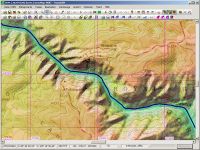
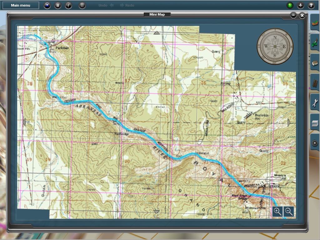
I have shown the following screenshots before which illustrate the combination of a good DEM and the USGS 1:24k topo map for the Royal Gorge in Colorado.
The way it looks in TransDEM (DEM shading enabled):
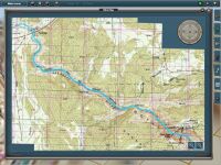
TransDEM-generated minimap in Trainz Surveyor:
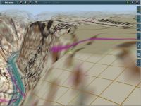
TransDEM-generated 3D terrain with ground texture in Trainz Surveyor, 5m terrain grid, TS12:
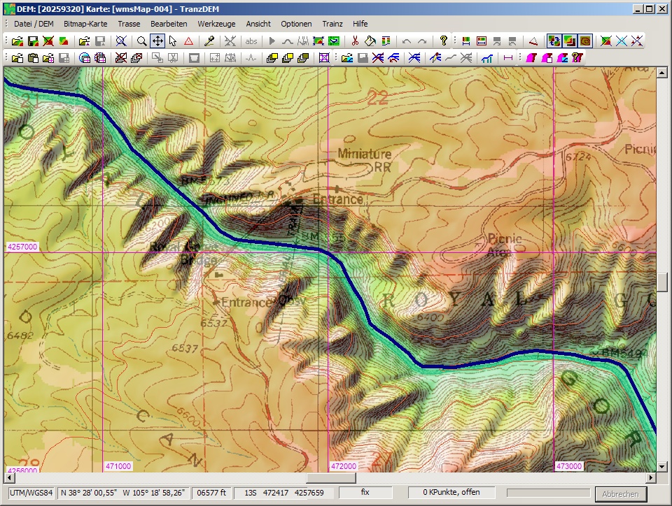
To get an idea for sharpness and the detail you can achieve with the ground texture, compare the label "Miniature RR" on the map in the TransDEM screenshot and on the terrain surface in Surveyor.
I have shown the following screenshots before which illustrate the combination of a good DEM and the USGS 1:24k topo map for the Royal Gorge in Colorado.
The way it looks in TransDEM (DEM shading enabled):
TransDEM-generated minimap in Trainz Surveyor:
TransDEM-generated 3D terrain with ground texture in Trainz Surveyor, 5m terrain grid, TS12:

To get an idea for sharpness and the detail you can achieve with the ground texture, compare the label "Miniature RR" on the map in the TransDEM screenshot and on the terrain surface in Surveyor.
cascaderailroad
New member
Making DEM's & using TransDem, seamless server ... etc ... etc ... How difficult of a learning curve is it for someone with moderate map reading skills ?
Would it take me weeks or months to learn how to do it ?
I have briefly read the tutorials, and I oftentimes thought it beyond my skills and patience, concentration.
I applaud you fine skills !
Would it take me weeks or months to learn how to do it ?
I have briefly read the tutorials, and I oftentimes thought it beyond my skills and patience, concentration.
I applaud you fine skills !
Thanks. For the USGS seamless server, gathering maps and DEM data is very easy. There are tools or filters to narrow down your specific area. I think it would take around 20 minutes at most for someone with moderate map reading skills. I had Transdem for about 4 months now and at first, I did not really want to read the turorials and manuals. I just wanted to get DEM data into the game. For about the last week or so, I dedicated time to reading the tutorials on the transdem website, read part of the manual, and completed the muengsten tutorial.
Status: Working on Amtrak Empire connection between George Washington Bridge and Inwood.
Status: Working on Amtrak Empire connection between George Washington Bridge and Inwood.
Last edited:
We now have some screenshots everyone. These screenshots for the Major Tri State Area Project take place on Amtrak's West side line between the George Washington Bridge and Inwood, Manhattan. So far, on my Dell laptop with Integrated Graphics, this route is running pretty smooth with all the trees close to the roads and tracks. When I am route building, that is when it begins to lag but I think that happens to most route builders. Well, here are the screens.

Amtrak P32AC-DM hauling some Amfleet coaches bound for Penn Station. This is just south of Dyckman under the Henry Hudson Parkway.

Rear shot of the above Amtrak consist.

What a surprise. Here, we have a 1990's set which consists of an FL9 and horizon coaches bound for Yonkers.

Viewing a lighthouse under the George Washington Bridge from the Hudson River.
Amtrak P32AC-DM hauling some Amfleet coaches bound for Penn Station. This is just south of Dyckman under the Henry Hudson Parkway.
Rear shot of the above Amtrak consist.
What a surprise. Here, we have a 1990's set which consists of an FL9 and horizon coaches bound for Yonkers.
Viewing a lighthouse under the George Washington Bridge from the Hudson River.
Similar threads
- Replies
- 2
- Views
- 1K
- Replies
- 26
- Views
- 6K
- Replies
- 0
- Views
- 98