Is their a Vista Map or equivalent for TS2010 & TS12?

G'day Red_Rattler, no mate there was an attempt to make it work in TS10 but it's functionality was very limited and N3V seems to think the map view is sufficient and that we can copy and print that (using heaps of unnecessary printer ink).
Regards
Barrie
 
Really? Why? Why not post in his thread asking this, or even better, sending a PM? The CALLING Philskene in the title of your post will do NOTHING to assist him in seeing this post...

I don't think the map his even his, however it was made using a model layout designer... You don't know google very well do you? http://www.newrailwaymodellers.co.uk/xtrkcad.htm

Personally, I'd suggest inkskape, however I will not give you a link to the site, and I will force you to acquaint yourself with google. (not even going to give you a link to google)
 
H222 -

'Tis OK.

Red_R --

That map was provided by the person who wanted the route constructed.

Do a Google search with "model railroad planning"https://www.google.com.au/search?sa...a=X&ei=2qU1Uqz9L475lAXruoC4CA&ved=0CCgQvwUoAA

and this is one of the results:

http://www.scarm.info/index_en.html#screens

and this is one of the maps:

Sample2_N_1.jpg
 
Okay thanks Philskene

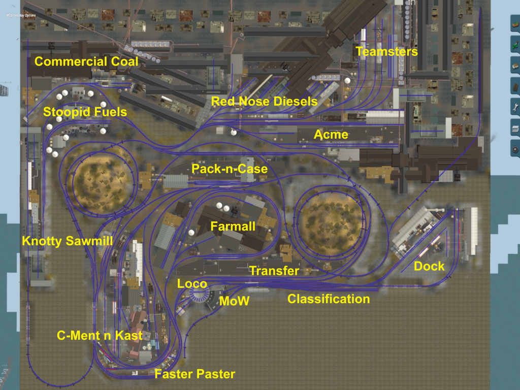
That's the sort of map, that N3V needs, as it look like it can show different types of track in different colours.

Oh by the way, Philskene, I had to heavily edit it (most of it), as for some reason, I was having a technical issue with the editing.

Edit: Philskene, I've just downloaded it, and scanned it for security checks, but I've got a security warning

"The publisher could not be verified. Are you sure you want to run this software? . . ."
This file does not have a valid digital signature that verifies its publisher. You should only run software from publishers you trust."
 
Last edited:
That security warning is standard for most software anyway, especially from smaller companies and individuals. Most of the time, it's safe to ignore it.

Shane
 
This is cool software and it would be nice if this capability was available in TS10 and up. I believe, N3V has changed the internal structure again of the route data so this is what has killed the old VistaMap.

If there was a way to extract the .trk data information, I'm sure someone could convert this to a vector position for plotting in a program such as SCARM. This kind of capability would be really useful for not only publication but also for route modification and planning. Having a print-out in hand, and writing notes on it would be very useful for setting up sessions and driving notes. Having this information available as a PDF or some other portable format would definitely be useful for the multiplayer community as this would give them something to share amongst the group to familiarize the members with the route layout and industry location.

John
 
Philskene, I note you state for most of your images "(Note to Moderators - all images are compressed.)".

I believe if you make them clickable thumbnails, going back to the original picture, or a larger size picture, their may not be a need to include that reference.

But I'll make this a suggestion later, but we need a map, that we can generate schedules from, with the timings, similar to what MSTS1 did. It would save all this choosing this, then choosing that, then choosing this via that, etc & etc.

Phil, Acme products?? So where's Wile-E-Coyote then?

"Stoopid Fuels" ?? :D
 
Last edited:
The images are compressed down to about 95 kB so that they load faster.

Yes and "Red Nose Diesels" as in Santa's helper = Rudolph Diesel , the inventor of the diesel engine cycle.

DowntownTraction has "April Fuels".
 
Red - That would be an awesome idea. Imagine generating an almost automatic schedule that way. :)

The rules regarding image size has been relaxed a bit. the 1024 x 768 sized image here is okay. Check the code of conduct for the current spec.

John
 
Back
Top