How to make realistic Valleys/Mountains

0099

Trainz Legend
Hey All

Awile ago i came accross a great way to make realistic mountians and/or valleys.

Now first of this might be known by older members but i haven't seen this way used on any other route ive downloaded.

Step One : Next to your railway line/road raise the land by about 2 ( anythings ok but 2 works the best ) so it turns out like so ....
tut1yl4.jpg


Step Two : Next raise the land to 4 [ etc ] right next to the "Two" so it looks like this ...
screen03to7.jpg


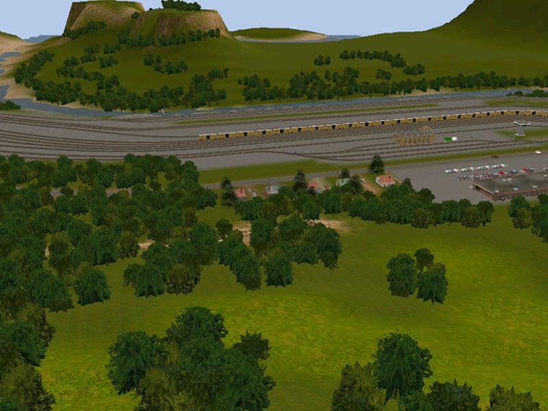
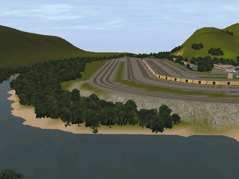
Then continue working up going higher ( Try to change how higher all the time so it looks more realistic ) untill you get results like this ...
beforext0.jpg


And there you go realistic valleys/ mountians:D .

Cheers

Anthony
 
Wow....:eek:

But what if you have the line running through the mountains? How can you do that? This is only for running ground level.

I have raised the track up to the pefered high I want it on the mountain but cant find an effecient way to make the mountains so they look relistic around the track.

Any ideas on this issue?
Thanks!

Cheers,
Adam
 
This is my system of mountain building. Start by laying some track.

Demo1.jpg


Let's add a grade to make it interesting.

Demo2.jpg


Now go into the Topology tab, choose the largest radius, set the sensivity dial at 9 oclock, and start blipping the mouse under the track to bring it up to track level.

Demo3.jpg


Demo4.jpg


Now you're ready start blipping the area on both sides of the track to raise the terrain. Keep filling in the low spots as the terrain rises.

Demo5.jpg


Now, you're ready to use the spline smoothing tool to level the terrain under the track

Demo6.jpg


Let's add a dry run. Start by laying some track parallel to the original rail. Give it a slight downward grade. Now, using the spline smoothing tool,apply it to the track to create the run, and then delete the track.

Demo7.jpg


Let's add a wooden trestle to complete the job.

Demo8.jpg


And there you have your mountains. Ready for ground texture and trees. I generated this project in about 20 minutes. Several years ago, using this system I built a route that's about 20 miles long.

I call it Poor Man's HOG. Give it a try, it's not that hard.

Good luck, Joe
 
Effecient Mountains?

Adam, you said --
I have raised the track up to the pefered high I want it on the mountain but cant find an effecient way to make the mountains so they look relistic around the track. --

I've run into the same problem, and found two ways to get around it, neither paticularly efficient. One is to terrace the terain (using the hieght from your spline points), the other is to build the treain and then smooth it around the track. I have had satisfactory results from both however the second is beter at rolling terain.

I should also mention my good grasp of spatial relations, as well as my defency of computer skills.;) {What do mean, don't? You can adjust it with a 4lb. hammer, right?!}:hehe:
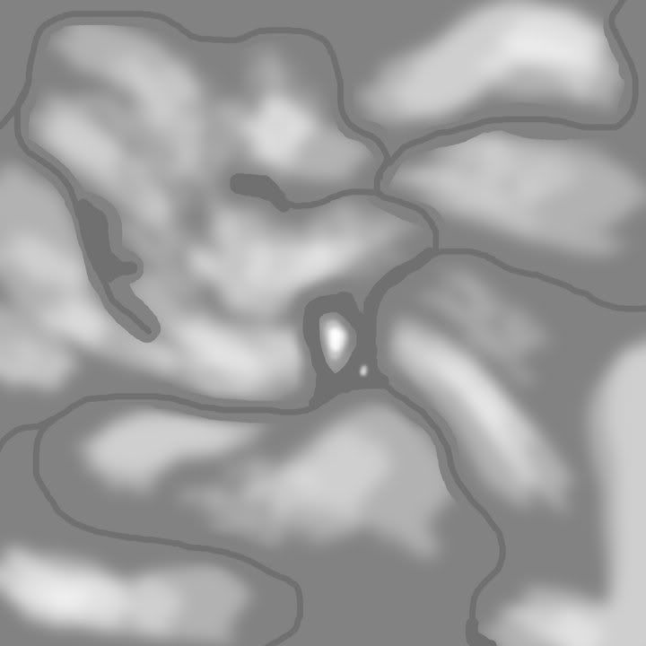
 
Last edited:
I make all the hills and valleys for my routes using Photoshop to make the Displacements.

Here's one I made. The lighter areas are hills, the neutral is flat ground and the dark lines are rivers & lakes:

HillsRiversLakes.jpg


Here's two samples of the effects I get:

ascreen2.jpg


ascreen1.jpg
 
Davesnow, those two pics made using Photoshop look superb. Any chance of a tutorial on how to transfer stuff from Photoshop to Surveyor?
 
Davesnow, those two pics made using Photoshop look superb. Any chance of a tutorial on how to transfer stuff from Photoshop to Surveyor?

There used to be a tutorial somewhere on-line, but I haven't been able to find it. Let me see what I can do. . .
 
I would like to know how the Mountains are made in the displacement image. I roughly know the 0 elevation color, could see doing water but hills/mountains is where you lost me.
 
TSwenson and jrfolco, I like your ideas a lot...its just my track is up high....really high. Say 35-40 spline height.

I will try both your ideas and see what works best. There is two problems when it comes to terrain for me: Mountains and Hills. I dont know why but I can never make them look right.

I have been using Padsters idea for awhile now (One he made in the OnTRack magazine a long while back) and it seams to look good but I'm searching for something realistic.

Cheers,
Adam
 
Wow....:eek:

But what if you have the line running through the mountains? How can you do that? This is only for running ground level.

I have raised the track up to the pefered high I want it on the mountain but cant find an effecient way to make the mountains so they look relistic around the track.

Any ideas on this issue?
Thanks!

Cheers,
Adam

What about just raising the land except insted of starting at 0 start at 36 or something ( Depending on how high your track is )

After reading jrfolco's tutorial i gather mines the stupid one but it does give results if your patient:) . [ No im not calling anyone impatient just in case]


Anthony
 
So the tutorial wasn't very helpfull?

Im not really sure of how helpfull it is from looking at the comments:confused:
 
Personally, I think it was helpful, just that the method is very time-consuming. I usually use that method when adjusting specific parts of terrain in a certain scene, not over a whole map or even baseboard.
 
There's a few Surveyor tutorials on my site which you might find useful, including the smoothing of displacement maps to get the result you want.

Just click on my banner to go there.

Nice tutorial Dave.
Displacement maps are very underrated IMO.

Smiley.
 
What I tend to do, and it works fairly well, is to run my track out first. I then use apply Vertex height or apply gradient to position my track at the proper gradient and height. That is stage 1.

Stage 2 is where I use Smooth spline height on the track sections, to bring the land up to my track.

I then use the 'Get height' in Topography, and 'Use height' to play a large flat area spanning the full width of the baseboard, at the level of the track.

Every 5 or 10 meters in height, I lay down a new flat section at the new height. I make sure I am careful not to allow the sensitivity of the Topo radius brush over ride my neighboring lower or higher section. I make nice gradual transitions between each section level.

I can then use the Height up tool on low sensitivity, to create hilly terrain along side the rail. Or use the Height down tool to create valleys and lakes along side the rail. After its done you can't even tell where the sections used to be.

I am sure not to create any super steep slopes, and prefer to have nice rounded hills.

After my hills look ok, I use the Smooth spline height tool again on my track to make the various cuts and fills as my rail traverses the mountian.


I can usually complete about 1 km of hills and track (1 baseboard in width) in about 10 minutes or so. At the moment on my large route, my mountian pass I am working on goes up to about 1000 ft above the baseboard level. The pass alone when complete will be about 50 to 70 km.

Now as far as scenery... lol well, I have yet to really venture there on this route. ;)
 
Last edited:
Back
Top