This there a way to have a raw HOG map generated in Trainz with the groundcover already added? I have a rather massive map generated and dread the thought of adding ground board by board. Any help would be great. Also I was looking at the trainz sites and saw a site on having the rails laid when generating a new route ( following TIGER lines) which program does that transDEM? Again if it is possible it would greatly cut down my route time and be able to offer the route to the DLS
Install the app
How to install the app on iOS
Follow along with the video below to see how to install our site as a web app on your home screen.
Note: This feature may not be available in some browsers.
You are using an out of date browser. It may not display this or other websites correctly.
You should upgrade or use an alternative browser.
You should upgrade or use an alternative browser.
General Question on surveyor/maps
- Thread starter csxman
- Start date
Alan_Yeomans
New member
First ive ever heard of either of these features.
I doubt that it would be anywhere near as good as doing it by hand.
Perhaps someone else can adivse how his is done (if its possible)
I doubt that it would be anywhere near as good as doing it by hand.
Perhaps someone else can adivse how his is done (if its possible)
Yes
Buy a ready made Marklin Z Gauge Toy Railway
Buy a ready made Marklin Z Gauge Toy Railway
First ive ever heard of either of these features.
I doubt that it would be anywhere near as good as doing it by hand.
Perhaps someone else can adivse how his is done (if its possible)
WileeCoyote
Eatibus Almost Anythingus
The second one I think is very complex and needs a CAD based program, I would suggest sending a PM to geophil about it.
WileeCoyote
WileeCoyote
HOG and TransDEM both shape a Trainz map based on DEM data. They both can also create basic ground textures usually for representing a topographic map to facilitate orientation, often in conjunction with the minimap.
TransDEM can also place track splines in a Trainz map. It needs input data for this in the form of vectors or polylines. TransDEM comes with a simple built-in polyline editor which allows to quickly trace railway lines on topographic maps or orthophotos, loaded in TransDEM. However, track splines created from route tracing will usually lead to rough track, not suitable for immediate train operation. Such track should be seen as a template for further elaboration.
If you have access to fully elaborated track vector data, TransDEM can also create accurate 3D track splines from that. In this case including junction placement and terrain adjustment (cuttings/embankments). As WileeCoyote says, if you want to create such data yourself, you will need an additional CAD-like tool for this. Some model railroad track laying tools may suffice but I am not sure. Bob Pearson has a bit of experience with this. My own examples are all created with tools for the German rail simulator Zusi but I would not recommend the current toolset, too complex, German language only and to be replaced with a much better one.
geophil
Thank you
You have all been great. Phil I will be sending an email to you for TransDEM, seems that the program is better than the MicroDEM I have been using. I have AutoCAD 2006 on my system, as well as GMAX. I will get in touch and see if there are any tutorials on how to do that. Thanks again!
You have all been great. Phil I will be sending an email to you for TransDEM, seems that the program is better than the MicroDEM I have been using. I have AutoCAD 2006 on my system, as well as GMAX. I will get in touch and see if there are any tutorials on how to do that. Thanks again!
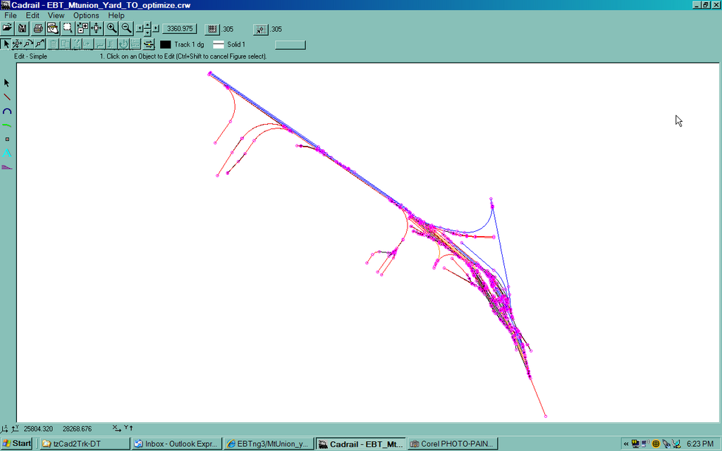
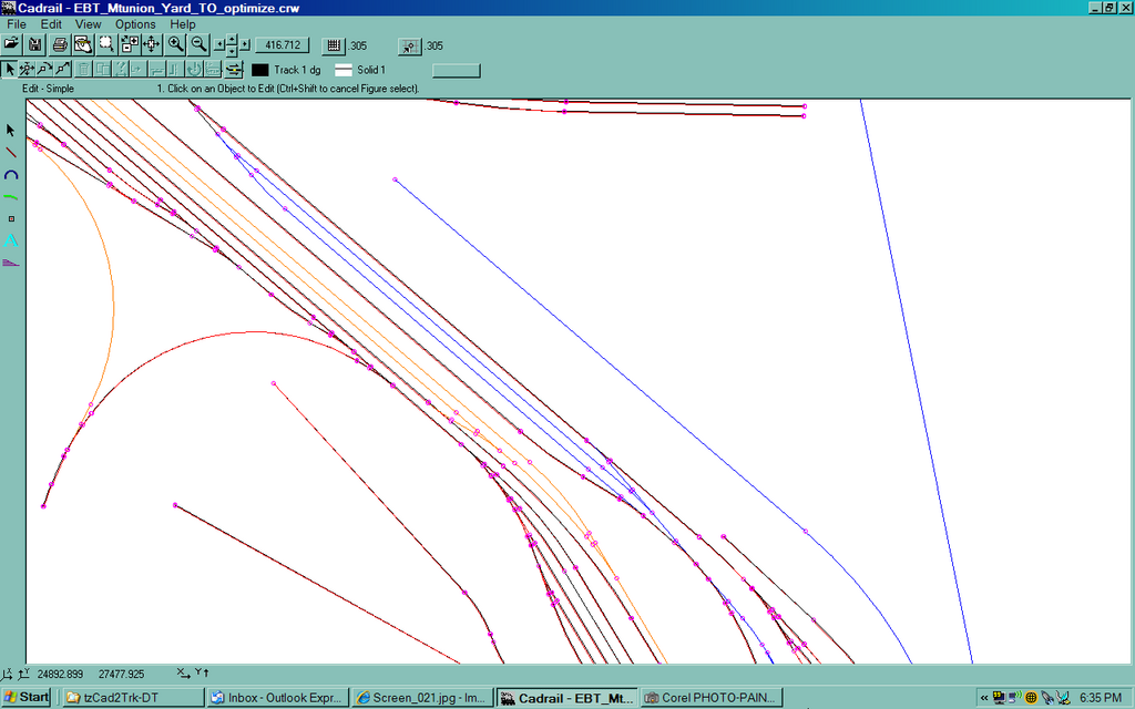
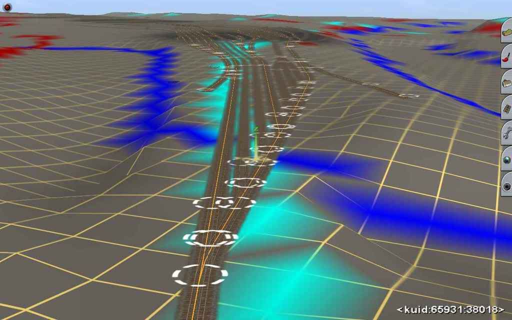
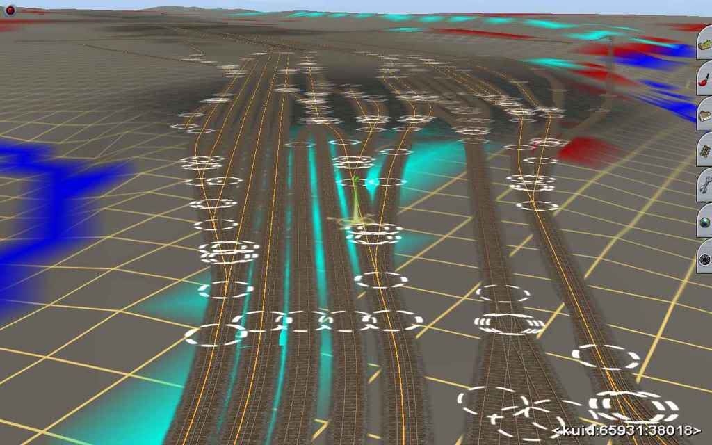
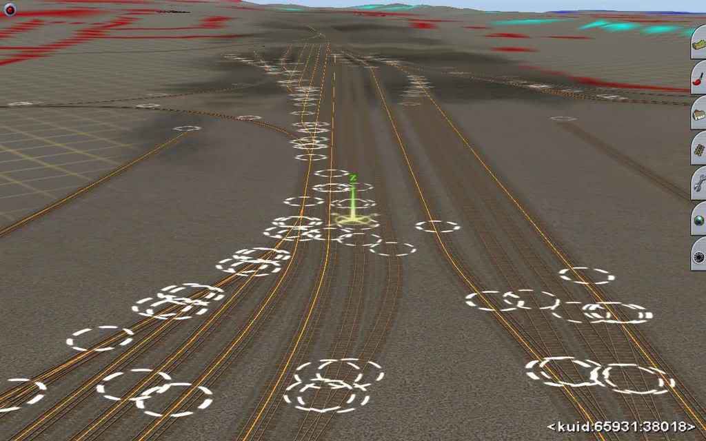
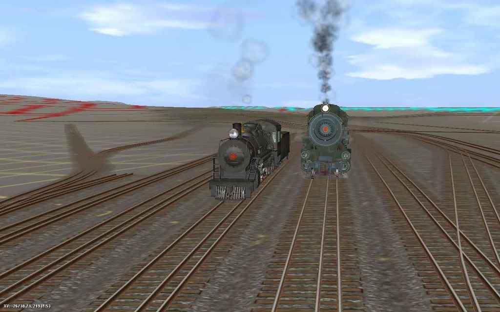
Alan, track laying outside Surveyor has been possible for a while now. I have a utility that does it from cad drawing dxf exports and Geophil's TransDem can do it from similar type vector data. The following are a few screen shots of a route I'm working on that show the EBT's Mt Union Yard with a combination of ng3, std and dual gauge track. The 1st 2 are of the cad dwg as created in Cadrail. The others show the track in Surveyor - none of which was laid manually - it's all done by the utlity program. The orange splines shown in Surveyor are the invisible track that forms part of the dual gauge -all laid exacty 10.25 inches off centerline.First ive ever heard of either of these features.
I doubt that it would be anywhere near as good as doing it by hand.
Perhaps someone else can adivse how his is done (if its possible)
Bob Pearson
TrainMan12
New member
So, from what I understand, it's possible to have the ground/textures automatically applied? I didn't quite understand the question or answers. Is the program freeware or payware?
TrainMan12
New member
I mean the actual textures, not just the TIGER lines.
MicroDEM from my understanding can create the ground textures, and transDEm can create the rail placement. I do lik the CADrail shots! I am in the process of getting transDEM from phil, and may just have to get CADrail. Though would GMAX or AutoCAD2006 produce the same results with transDEM?
You can apply any bitmap to the ground using TransDEM . However, TRS is limited to 10m resolution when applying textures this way, so this would give you a very low-res result (basically one color per grid square). I'm pretty sure TransDEM does have an ability to automatically apply ground textures by kuid to a map, but I haven't played with that feature yet.I mean the actual textures, not just the TIGER lines.
Something like Terragen, where you can assign parameters (slope / elevation / randomness / etc) might be nice. It would give you a starting point for a map, anyway
")
Anyone ever bother to read the manual that comes with one of the HOG versions? It's not just for TIGER data. Maybe not what you were thinking of but it's as close to automatic ground texturing as you'll get for free.I mean the actual textures, not just the TIGER lines.
Bob Pearson
advanced functions.
route painting
Aside from simple generation of blank .gnd files, the terrain generator is also capable of painting its creations with predefined textures. This ability can be used in a number of ways:
- To paint terrain with basic colours, in accordance with supplied satellite photos.
- To overlay vector data on the layout, not just in the mini map window.
- To cover selected areas of the generated terrain with specified Trainz textures.
The painting function is invoked with following switch:
-Pguide.tga for painting with randomized textures or:
-pguide.tga for painting without trying to mix the textures.[this option is slightly faster, and can be used when 'painting' vector data, e.g.]
- guide.tga: the name of picture which will serve as guide for terrain painting.
Geophil will have to answer for the requirements on vector data to use with TransDem. I don't have a copy - all the track in the screen shots I posted was created with tzCad2Trk that I wrote. Cadrail is a small cad program designed primarily for model railroad design but can handle full size routes of fairly large size. The EBT's main line is abt 32 miles long and has several branch lines that almost double that. Add in the McKelvey Bros Logging RR and part of the PRR thru MT Union and I have well over 75 miles in the full cad dwg. Not huge but good size. I had a copy I used ocasionally which is why I wrote the utility.... I do lik the CADrail shots! I am in the process of getting transDEM from phil, and may just have to get CADrail. Though would GMAX or AutoCAD2006 produce the same results with transDEM?
I wouldn't recommend you go out and buy a copy unless you planned on doing a lot of layout design work. It would cost more than TransDem and Trainz put together - not a lot for a cad program but still a bit steep for pretty limited use with a hobby. Actually any number of other cad programs will work with my utility as long as they can export a dxf file. Gmax doesn't so it won't. I can't say whether Cadrail or any other cad program output will work with TransDem as I don't have a copy.
Bob Pearson
Last edited:
As I said, I use the Zusi tools for track geometry. These tools are quite powerful, but I do not recommend them in the current version: a bit complicated to use and only very basic English documentation.
See the last two screenshots on my web-page here: http://www.rolandziegler.de/StreckeUndLandschaft/transdemTrainz_Engl.htm
They show the result of TransDEM track laying with elaborate 3D vector data, applied to a raw DEM terrain and without touching any Surveyor function except for positioning the point of view.
TransDEM can export/import vector data in a few file formats. The preferred one for exchange with a CAD tool is .dxf. Another option could be .gpx (GPS/XML) with tracks.
When using .dxf TransDEM writes UTM coordinates. AutoCAD should be able to handle the coordinate value range. TransDEM can read dxf vector data in most coordinate systems it supports and will convert to UTM during import. In .gpx coordinates are always WGS84 lat/long.
Geometric shapes supported by TransDEM in dxf format are lines and polylines, 2D or 3D. (Elaborate track geometry should always be 3D.)
geophil
Similar threads
- Replies
- 7
- Views
- 245
- Replies
- 18
- Views
- 1K
- Replies
- 36
- Views
- 4K
- Replies
- 1
- Views
- 288