Creating Displacements in Photoshop

Here are a few Displacements I created in Photoshop:

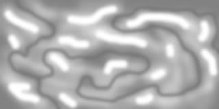
first, a long type, about 3 boards tall by 30 or 40 boards wide. I like these kind because I can make long routes.
40x3-1.jpg


Here's more of a Rectangular layout... maybe 10 boards tall by 30 wide. A winding river with lots of hills around it.
RiverGorges4.jpg


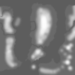
This is a really large square layout, a pensinsula surrounded by the ocean, with land on both sides. For this one,I recommend around 40-50 boards square:
Peninsula.jpg


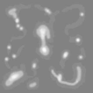
Sometimes I like Island layouts because your "whole world" is contained here... no imaginary roads leading off into oblivion!
DoubleIslandChain.jpg


This is another basically square layout, a large lake surrounded by hills. You could add a lot of steams and rivers so the lake could be fed by a multitude of rivers:
BigLake.jpg


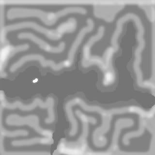
For those who don't know, the darkest areas are rivers, lakes, ocean... the overall gray is flat land... the lighter gray & white is hills, mountains, peaks.
 
Mountain peaks are inclined to have sharp points. Can this be smoothed out?
The DLS does not cater for displacement maps. A pity.
 
Don't know exactly what you mean by "smoothed out." Depends on your setting in Surveyor when you lay in the Displacement-- I think that's what you mean... In any case, you can use the "Plateau" tool to gring off any really sharp points.

No, the DLS doesn't have Displacement Maps. Yes, it is a pity.

Another thing, I haven't got TRS 2009 to use Photoshoped Displacement maps. Doesn't work. Doesn't matter to me though, because 2009 has so many bugs I'm sticking with 2006. [sounds like the old 2004/2006 battle doesn't it!?]
 
It is easier if the mountains have no sharp peaks.
I changed the volacano and now have an almost exact copy of the Magaliesberg mountains.
 
i know its interupting, but thank you so much for this, without this tutorial, or me even knowing how to do this, i wouldnt be able to create my next map! i simply can now trace over the contour lines on maps! its great!
 
i know its interupting, but thank you so much for this, without this tutorial, or me even knowing how to do this, i wouldnt be able to create my next map! i simply can now trace over the contour lines on maps! its great!

You are very welcome. Good luck on your route!!!:)
 
using gimp

It's located in the "World" "Custom" folder. And don't forget what file name you used! You're all set!

ok im doing this with gimp. its in the custom place-i can see it-but it doesnt have a microsoft icon-so it wont show up in the pictures-how do i get it into microsoft
thanks
steve
 
I'm sorry, but I just can't understand what you mean... does anyone else unerstand what beeb49 is talking about?
 
Hi Dave,

Thanks for the good info on creating displacement maps. With regard to TS2009 and displacement map here is something I posted in another thread about them.

TS2009 SP2 does not read the World/Custom folder and add content there to the Trainz Asset Database at startup anymore like older versions. This is a part of a move away from having assets outside of the TAD. There is now a new asset kind "GroundBrush" for creating displacement maps available in CCP.

Choose New from the file menu in CM2 and a new asset will be created and opened for edit in CCP. Choose GroundBrush as the type. Fill in the fields for the config.txt. Here are mine:

kuid <kuid:xxxxxx:1044> This will be created for you.
username "Displacement Map 2" Choose your own name here.
trainz-build 2.9
category-class "JO"
category-region "US"
category-era "2000s;2010s"
kind "groundbrush"
displacement-bitmap "f_001.BMP"

Before you can choose your bitmap at the bottom you must copy your image to the folder that is open in your TS2009 folder's Editing folder. This should be called New Asset at the moment. Now you can choose the image in the requester. Save the config and exit CCP. Now commit your new asset and your displacement map will show up in surveyor. Beside using it with the fill button, you can also choose a displacement map and then use the height up and down tools with the displacement map effecting how they change the terrain.

By the way, the bitmaps don't have to be 256 x 256. They can be up to 2048 x 2048 which is quite useful on a 5m grid. They can also be jpeg files too.

And yes you can now upload them to the DLS.:D

William
 
Last edited:
Thank you, William for the update on the displacement maps. I noticed that my custom displacement maps had disappeared from the list and I was going to ask where they went.

John
 
Is there a way to set the sensitivity, apart from rotating the handle in Surveyor? Maybe by fiddling some obscure parameter in some semi-hidden file? Is this information stored with any new map, or is it reset to zero each time Surveyor is started? If the latter is true, is it possible to set the default value to another figure?

It would be nice to know in advance (while the map is being drawn) that a RGB code of (154, 154, 154) equals 283 metres above sea level and that every increment in the RGB code represents 3.78 metres.
 
That must be an addition from SP2, I assume, because I don't have it available.

Yes, I'm pretty sure it is only in SP2. I've been doing testing in the open beta program at trainzdev so I saw it first in a beta build somewhere between SP1 and SP2. If you have SP1 then the custom folder should still be read at startup and displacement maps placed there should still show up in the game.

William
 
I cant get custom displacements to work in T:ANE. The name shows up in the selection menu, but when i select it, the preview window is blank and trying to use it produces no terrain changes.

Edit: When i check the errors and warnings, i get 3 of them:

-Blah blah blah build numbers below 3.5 not supported.
-Required tag 'category-class' was missing and has been set to default.
-Required container 'thumbnails' is missing.

These errors come up on an un-modified, newly cloned displacement, and i have no idea how to fix this.
 
Last edited:
Back
Top