Install the app
How to install the app on iOS
Follow along with the video below to see how to install our site as a web app on your home screen.
Note: This feature may not be available in some browsers.
You are using an out of date browser. It may not display this or other websites correctly.
You should upgrade or use an alternative browser.
You should upgrade or use an alternative browser.
Australian screenshots
- Thread starter cook
- Start date
Yeah, having just come off night shift on Friday morning, and trying to adjust my sleeping pattern for an 0600 sign on on Sunday, I spent a rather forced sleepless night last night (didn't help that I slept until 1600 on Friday, haha). I think I have the yard to the level I want it to be at, now it just remains to have objects, roads etc added, before I can start building up the town.
Contrary to my earlier ideas, this is no longer the terminus, although this will be the major town on the branch line. I plan on having another two locations further up the line, although they will be only for grain loading on this incarnation of the map. I'm planning on having three different "eras" of map made. The current map being made is set in the 1990's - ie anywhere from 1990 to 1999. I also want to do a "version" set in 2010 (so chop up most of the yards and leave only the passenger platforms and the grain/container loading facilities), as well as a version set in the 1980's (so the large container terminal at Weston won't exist yet, for example).
Those of you who have been paying attention will know that the container terminal has moved from behind the cement unloader (not enough room between the cement unloader and the river) to west of the main yard area. I figure, when they built the facility, they likely wouldn't have found any room in the existing yard, and rather built it just outside of it. The "old" container terminal will be a container and general goods siding in the 1980's incarnation, and will likely be closed in the 1990's version, and removed in the 2010 version!
Anyway, enough chat. We're going west-east, heading back towards the screenshots already posted of the landscaped and textured part of the route.
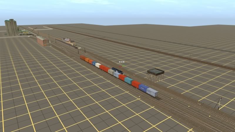
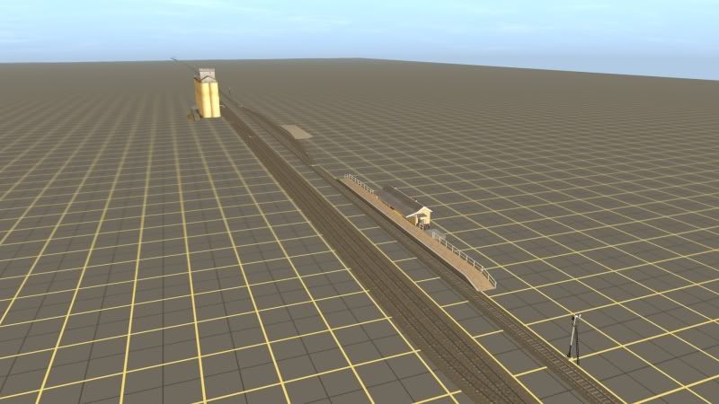
(Looking west - this is the current end of the line next to the container terminal, which can fit roughly 30-35 3 TEU wagons (pictured are 33 NQOY wagons, although in modern times, these will be replaced by CQBYs)

(Looking east - the container yard is behind us. The two sidings on the left of the yard are wagon storage, with the loco shed and turntable to the right of the mainline).
(Looking west again. The main line is the first non-rusty track from the left to the right. This is followed by the loop, then siding no 1, siding no 2 and the goods siding (loading bank).
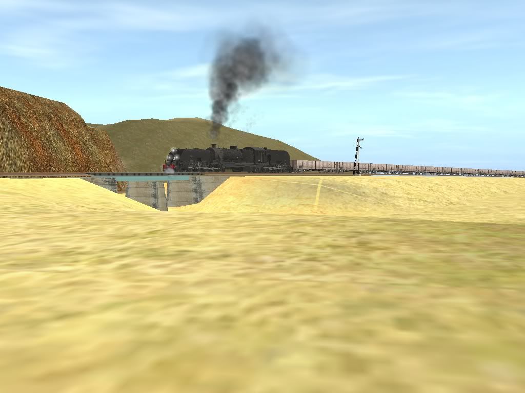
(Looking south-east. The loco shed is to the right of frame. Pictured is 4812, the current "Weston shunt loco", which is also used to run a trip train to the next location to the west using the 5 container wagons pictured. The Weston shunt loco is also used to shunt Old Weston grain silo (see below)).
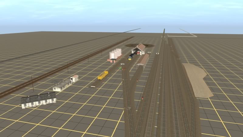
(Looking east. 4812 and wagons are just out of sight behind us. Pictured is the Weston "Wombat Flour Mill", which accepts rail hauled wheat, and exports flour in both bag and bulk. Behind the flour mill is Weston "Blue Circle Cement" unloader - cement is railed in from Clyde in Sydney to be distributed locally. Note the station is on a loop seperate from the mainline, to allow a terminated passenger service to sit clear of the mainline. Any loco hauled trains can also run around without getting in the way of freight shunting, and can easily set back into no1 or no 2 carriage siding).
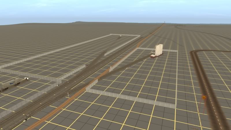
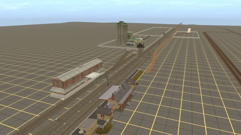
(Looking north east. The siding on the left is the freight terminal. This will be loading and unloading wagons with processed freight for market. Prior to the intermodal terminal, this siding will also be used to load container wagons. The siding on the right of the mainline is the Ampol siding - ignore the shell sign, I haven't found an appropriate Ampol sign!)
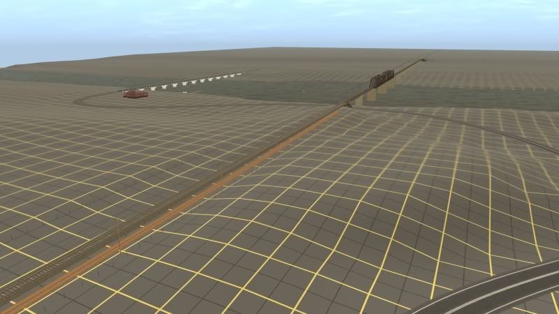
(Again looking north east. This is Weston River, the major obstacle for the railway line back in the late 1800's, or whenever the line was built... :hehe: )
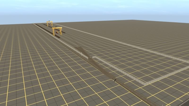
(Looking west - this is Old Weston, the original terminus of the (funnily enough) Weston Branch. This is where all grain for Weston is railed out, although the remains of the loco shed, turntable and goods yard have long been obliterated.)
Contrary to my earlier ideas, this is no longer the terminus, although this will be the major town on the branch line. I plan on having another two locations further up the line, although they will be only for grain loading on this incarnation of the map. I'm planning on having three different "eras" of map made. The current map being made is set in the 1990's - ie anywhere from 1990 to 1999. I also want to do a "version" set in 2010 (so chop up most of the yards and leave only the passenger platforms and the grain/container loading facilities), as well as a version set in the 1980's (so the large container terminal at Weston won't exist yet, for example).
Those of you who have been paying attention will know that the container terminal has moved from behind the cement unloader (not enough room between the cement unloader and the river) to west of the main yard area. I figure, when they built the facility, they likely wouldn't have found any room in the existing yard, and rather built it just outside of it. The "old" container terminal will be a container and general goods siding in the 1980's incarnation, and will likely be closed in the 1990's version, and removed in the 2010 version!
Anyway, enough chat. We're going west-east, heading back towards the screenshots already posted of the landscaped and textured part of the route.
(Looking west - this is the current end of the line next to the container terminal, which can fit roughly 30-35 3 TEU wagons (pictured are 33 NQOY wagons, although in modern times, these will be replaced by CQBYs)
(Looking east - the container yard is behind us. The two sidings on the left of the yard are wagon storage, with the loco shed and turntable to the right of the mainline).
(Looking west again. The main line is the first non-rusty track from the left to the right. This is followed by the loop, then siding no 1, siding no 2 and the goods siding (loading bank).
(Looking south-east. The loco shed is to the right of frame. Pictured is 4812, the current "Weston shunt loco", which is also used to run a trip train to the next location to the west using the 5 container wagons pictured. The Weston shunt loco is also used to shunt Old Weston grain silo (see below)).
(Looking east. 4812 and wagons are just out of sight behind us. Pictured is the Weston "Wombat Flour Mill", which accepts rail hauled wheat, and exports flour in both bag and bulk. Behind the flour mill is Weston "Blue Circle Cement" unloader - cement is railed in from Clyde in Sydney to be distributed locally. Note the station is on a loop seperate from the mainline, to allow a terminated passenger service to sit clear of the mainline. Any loco hauled trains can also run around without getting in the way of freight shunting, and can easily set back into no1 or no 2 carriage siding).
(Looking north east. The siding on the left is the freight terminal. This will be loading and unloading wagons with processed freight for market. Prior to the intermodal terminal, this siding will also be used to load container wagons. The siding on the right of the mainline is the Ampol siding - ignore the shell sign, I haven't found an appropriate Ampol sign!)
(Again looking north east. This is Weston River, the major obstacle for the railway line back in the late 1800's, or whenever the line was built... :hehe: )
(Looking west - this is Old Weston, the original terminus of the (funnily enough) Weston Branch. This is where all grain for Weston is railed out, although the remains of the loco shed, turntable and goods yard have long been obliterated.)
Pete,
Nice tankers. They look good so far; can't wait to see the finished version.
Raichase,
I like the way that your route is shaping up. You've obviously spent a lot of time thinking about how you want to develop it. If only i could do that! At the moment my route is being developed a board at a time, progressing randomly northwards. That's my only clear goal: Push North!
Well, not really, but close too it. I do have an idea of what major industries i want to serve, as well as how long i want the mainline (approx. 60k's minimum) plus i want at least one yard, at this point being loosely based on the current arrangement at Broadmeadow.
Thanks to every one who answered my questions about the loading of cement tankers. The info shall be put to good use.
Matt.
D9007_Pinza
Murringo's shed foreman
G'day Pete,
That code panel is a bit high up on the wagon side. The photos of the NPSF hoppers on NSWRollingstock suggest that the bottom of the code panel is hlafway up the side of the tank. Also, AFAIK, the 80km/h restriction did not apply to cement tankers, except for the two prototype PDF/NPDF class tankers built in 1963:
http://www.nswrollingstock.com/NPDF.htm
Otherwise, looking brilliant.
Back To SAR Port Pire........
Hello Allo,
Here is some new screenshots from my work in progress of a representation of the SAR section of the Silverton Tramway. I remember as a kid; my father taking me to see the mighty ore trains hauled by SAR 400 Beyer-Garrat and possible banker by a dirty SAR T class.
I definatly know you are going to love this and possible give old forest runner a run for his money!:hehe: :Y:
The QGR Commissioner is back in style.........:clap:
P.S; Great To see You Back Mark and please do pop over to the Queensland Trainz section; I am putting up the hot muffins onto the window shelf.
Now Enoy 5 screenshots. ( I would love to put more but Auran have their limits)


Hello Allo,
Here is some new screenshots from my work in progress of a representation of the SAR section of the Silverton Tramway. I remember as a kid; my father taking me to see the mighty ore trains hauled by SAR 400 Beyer-Garrat and possible banker by a dirty SAR T class.
I definatly know you are going to love this and possible give old forest runner a run for his money!:hehe: :Y:
The QGR Commissioner is back in style.........:clap:
P.S; Great To see You Back Mark and please do pop over to the Queensland Trainz section; I am putting up the hot muffins onto the window shelf.
Now Enoy 5 screenshots.
( I would love to put more but Auran have their limits)
:wave:
Kindest Regards
Michael G
QGR Commissioner
Kindest Regards
Michael G
QGR Commissioner
Last edited:
itzemmyjane
stonks goin up
Jamie,Isn't that five shots?? Nice shots anyway
Jamie
Michael means he wants to post more than 5, but the limit is 5 max


Did they shrink it from 10??
Jamie
No, the limit is ten, but that is including smilies, as i found out the other day. If you count them, Micheal has ten pics all up, with the smilies. Weird i know, but hey.
While i'm here, i said earlier that i would loosely base a yard on Broadmeadow, for my current WIP. Before i do that though, could somebody please tell me what Broadmeadow is used for these days?
Google Earth shots from a few years ago show a few consists in the yard, such as an empty coal rake, container wagons and what appear to be endeavor/explorer sets (hard to tell.)
The diagram i have shows marshalling grids, shunting necks and a number of storage sidings. Are there any shunting movements carried out there any more?
Matt.
While i'm here, i said earlier that i would loosely base a yard on Broadmeadow, for my current WIP. Before i do that though, could somebody please tell me what Broadmeadow is used for these days?
Google Earth shots from a few years ago show a few consists in the yard, such as an empty coal rake, container wagons and what appear to be endeavor/explorer sets (hard to tell.)
Matt, thanks for the kind words on my route. I too am going a baseboard at a time, although I am pushing west
") .
.As for Broadmeadow, it is not as busy as it used to be. It's used as wagon storage and marshalling most of the time. There is an Endeavour Service Centre there (which now has a few Endeavours and quite a few Hunter cars). Often South Spur Rail Services/Silverton Rail used to store locos and rolling stock there when not being used, and to assemble their trains. I don't know if this happens now that SSRS has been absorbed by P&O Trans Australia.
QRNational used to shunt their BM7/MB7 intermodal trains there - loading for Sydney would be railed from Brisbane or Melbourne to Broadmeadow, where it would be shunted off the train, and loading for Brisbane or Melbourne would be shunted on. The train ran as 1451 from Yennora to Broadmeadow and as 4152 return. This train no longer runs, as QRN now shunt their trains at the old Glenlee coal washery sidings near Campbelltown.
Broadmeadow is also used to store trains that need to wait for an interurban to pass, or perhaps pause for a crew change without blocking the mainline.
Raichase,
Thank you (again) for the info . Much appreciated, as always. It's good to know that Broadmeadow is/was used for marshalling the odd train in recent times. With that info, i think will lay out the yard according to the diagram i have, when i get to it, that is!
It will be used for the marshalling of grain, cement and coal trains, the main traffic of the line. I could also use it for container traffic too, now i think about it. Maybe a mid-sized intermodal terminal somewhere close by?
Anyway, im starting to ramble. I'll leave everyone alone now, at least until the next operation-oriented question enters my head! :hehe:
Cheers,
Matt.
Thank you (again
) for the info . Much appreciated, as always. It's good to know that Broadmeadow is/was used for marshalling the odd train in recent times. With that info, i think will lay out the yard according to the diagram i have, when i get to it, that is!It will be used for the marshalling of grain, cement and coal trains, the main traffic of the line. I could also use it for container traffic too, now i think about it. Maybe a mid-sized intermodal terminal somewhere close by?
Anyway, im starting to ramble. I'll leave everyone alone now, at least until the next operation-oriented question enters my head!
:hehe:Cheers,
Matt.
Ghostryder
QDRN CEO
mattm
Broadmeadow was once the home to the Locos of both the Northern Division and the Northen Coal fleet. in the 1980s it become home to the Newcastle Cityrail fleet after their depot was moved from on the Foreshore. Broadmeadow was also a loco change point for freighters and passenger services and was even used as a stabling point for electric locos and electric car sets once the overhead reached Newcastle. Shunting used to be performed as required in the yard and numerous trip trains ran from the yard to various locations like the old Newcastle Yard the old Honeysuckle Yards, but these trip trains have slowly dissappeared consigned to History. Now as Raichase points out the yards used mostly for storage of rollingstock between either beign commisioned or between runs.
ghosty
Ghostryder
QDRN CEO
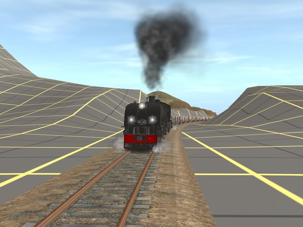
Just a little things i threw together to try a few things.

A cement works

Condemned rollingstock is placed in scrappers row.


Uploaded with ImageShack.us
ghosty

A cement works

Condemned rollingstock is placed in scrappers row.


Uploaded with ImageShack.us
ghosty

Ghostryder
QDRN CEO
electro,
Thanks, its loosely based on a place that i passed often as a kid, Both the Cement Works and the Scrap yard as loosely based on those on Koorangang Island in the Hunter area, i guess you can take the boy out of the Hunter but you cant take the Hunter out of the Boy.
ghosty
Thanks, its loosely based on a place that i passed often as a kid, Both the Cement Works and the Scrap yard as loosely based on those on Koorangang Island in the Hunter area, i guess you can take the boy out of the Hunter but you cant take the Hunter out of the Boy.
ghosty
D9007_Pinza
Murringo's shed foreman
I must say Ghostryder that's a nice "little" scrap yard you have there, only one thing I can fault, everything looks organised:hehe:
BTW, what is the kuid for that mangled pile of girders that looks like a tower and that pile of scrap in the back corner?
BTW, what is the kuid for that mangled pile of girders that looks like a tower and that pile of scrap in the back corner?
Similar threads
- Replies
- 0
- Views
- 509