UP West Line

ben i just really love your route
i hope this doesnt fall into one of those abadoned threads for an amaizing route, kinda like mine:hehe:
but mine wasnt all good
i had to rush it
anyways
please keep us updated
have a good rest of the day and have a good week of school
ONLY 3.5 WEEKS FOR ME!
 
Yep. I'm about there myself.

I've been working on this, but I'm not really to the point where having a screenshot would be very interesting. I just took my AP test about a week ago, and with the end of the school year comes finals, so I've been pretty busy. School has really been kicking me hard this year, so progress has been slow. However, I'm slowly but surely closing in on finishing all of the trackwork, which I can maybe have done sometime early June. By that time, I can start working on the scenery: my sole purpose for making this a screenshot thread. All the posts here that were just escentially housekeeping probably should've been on a Freeware Announcements thread or something like that.


Well, since someone brought this up, I mind as well show something. This last Saturday I started working on Proviso. :eek: 
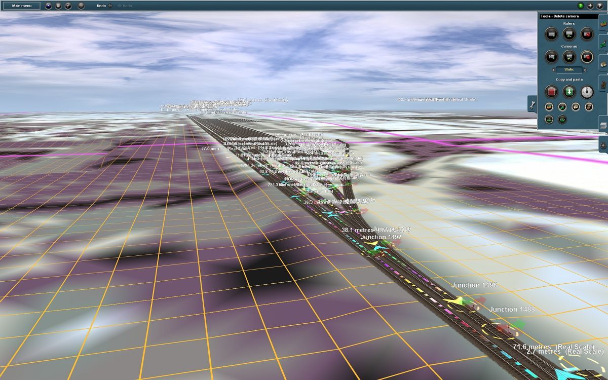
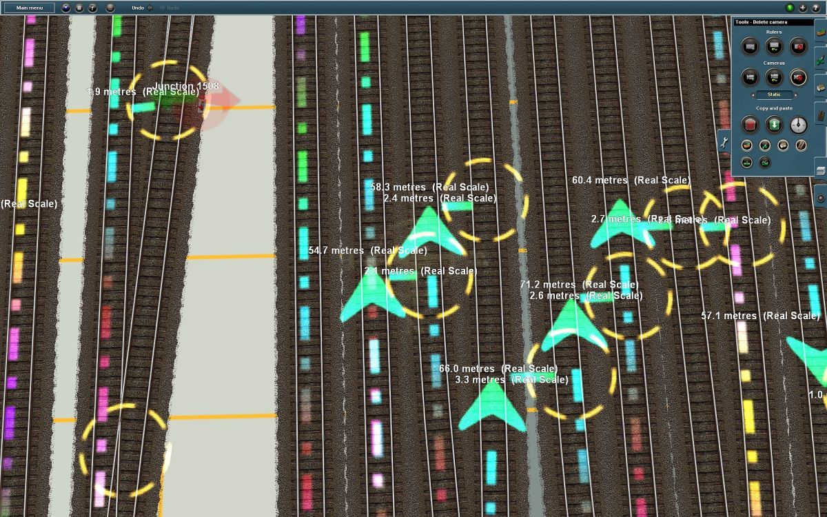
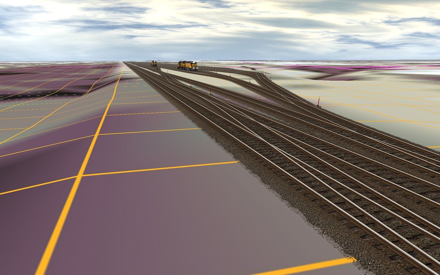
I've only really started work on the east bound receiving yard (see below), but am already exhausted.
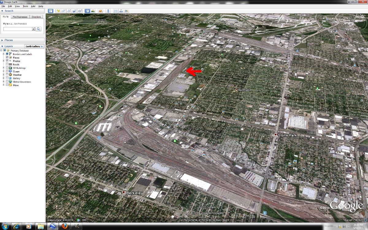
Area in question:
Prov1prog.jpg

(image from Google Earth)

Now, to give you a reason for my so-called exaustion:
UP4021_20110517_0000.jpg


And it's a little less than halfway done.


This is the extent of my obcession of making this as prototypically accurate as I can: I've gone so far as to roughly measure out the distance between the tracks... for every track.

Measuring in Google Earth:

Prov2prog.jpg


In game:

UP4021_20110517_0002.jpg


Too over the top and unnecessary? Maybe, but it has produced good results so far.
If I may flaunt some recent aquisitions minus rolling stock (to save on time and frame rates):

UP4021_20110517_0004.jpg


UP4021_20110517_0010.jpg


Anyway, for those who have, thanks for checking in, and I hope someone likes the progress so far.
:wave:
 
Last edited:
WOW that looks like a lot of measuring. Been there and done that...that is far from fun and beyond exhausting.

I'm not sure if it was mentioned before, but did you create this using transDEM? I'd highly recommend purchasing it and using it for two key reasons:

1) it'll make all the terrain for you
2) you can hopefully insert Google Earth tiles (images painted on a box) or MS Virtual Earth. This will help you immensely for laying track accurately.

Pretty much every person I know who has purchased transDEM was satisfied with it. I'm not on a mission to sell it or anything, but it seems to me like you are willing to put the hard work into this and I know how burnt out one can feel from trying to get everything exact (while using the default, but basic tools Auran provides - I'm not knocking them, it's just for something proto, they don't cut it IMHO).

Anyhow, whichever way you go, I'm sure it'll come out awesome in the end. :) Good luck on your exams and happy trainzing!

:wave:

Gisa ^^
 
Thanks Gisa. :)

Yeah, it isn't exactly fun. I guess it is for about the first hour or so with the help of some music, but gets a bit old after about the fifth hour. :p

Yep, I used TransDEM for this. It's really a wonderful program and, while I'm not selling it either, I would highly recommend it to anyone. I was going for the Google Earth overlay thing, but thought that the textures would cover that. I didn't get the whole UTM tile concept then. When I imported it, that is what it came up with, as the grass being a more or less purple color, and the track being kind of gray, but I just deceided to go with it. It makes me feel like I'm actually putting effort into it... and a lot of it at that. :hehe:

Thanks again for the reply Gisa.
:wave:

You're welcome for the reply. Glad to hear you used TransDEM for it. You are using 2010 for this, so you should have no problems using layers or getting the tiles in there.

I made some tutorials which hopefully, will help clarify what you can do and how to go about doing it. Go here:

http://forum.transdem.de/viewtopic.php?f=6&t=10&sid=873ea834b217c04da8a4ce027b27736f

Sounds to me like you just got the DEM data and went from there. You are missing the WMS maps (the stuff that paints a real map into surveyor/your minimap) and the tiles. You are really missing out!

The WMS maps are really easy to get and it is fairly quick too.

As for the tiles, you basically just download Google Earth images (or another provider: Maybe MS Virtual Earth will work for you), save them, import the images and create tiles. You've done a lot of work at this point though, but it might be worth your while to reimport the tiles. In fact, I think you can import the tiles without altering your trackwork. This I don't know how to do but I am pretty sure it is possible. Dr. Ziegler (Geophil) would know.

Basically, the tiles are the most accurate way of knowing what is where. It'll save you from having to measure stuff and you'll get better accuracy as a result.

The tutorials clarify it I think and have helped others too. PM me if you are stuck or need help.

:wave:

Gisa ^^
 
Thanks Steve. :D

And thank you Gisa. I'll have to take a look into all that. If TransDEM can import the tiles while saving all of the previous trackwork, that would be excellent. I have to get in contact with Dr. Ziegler soon anyway, so I could probably ask him then.

:wave:
 
You're welcome. I think it can be done, but he'd be the one to talk to.

Good luck!

:wave:

Gisa ^^
 
i am breaking every rule i have learned and this is the last you will hear from me in about a year, but serously Ben, nothing in 5 months, you serously need to get some new pics up there. So i beg of you, dont kill off this thread, get some more pics out
well i just had to say it and i prommise i have changed, no more gimmie gimme 817Taylor
please have a good one everyone out there
-817Taylor
A.K.A. 1976Buick
 
[facepalm]
No offense, but that post was bursting with irony...

EDIT: Not directed at you Kitty
 
Last edited:
[facepalm]
No offense, but that post was bursting with irony...

EDIT: Not directed at you Kitty

Indeed. :hehe:

Alright. I'm sorry I haven't had any updates. Remarkably, I've deceided to do what I figure teens my age should be doing, and going out and having a life. Even more remarkably, I've been liking it so far. That and I've been working on stuff for TrainzPA, and quite funnily enough... even you Taylor. So the long and short of it is that I haven't had time for it. Sorry. :(
 
Rather than just trashing it, I would suggest upload what you got as "abandonware", let whoever wants to take over and finish if you're no longer interested. Could hardly be worse than some of the really stupid routes I've seen on the DLS with straight mainlines on flat bare baseboards with a few trees. :sleep:

Proviso has defeated many before you, I knew at least 4 people who tried to build it in MSTS, one guy worked on it for years before he finally faded away. Proviso is the elephant in the old kid's joke;

How do you get an elephant into a milk bottle? (this was in the days when milk came in glass bottles, dunno what the current version is)

Answer; You need a milk bottle, an elephant, a pair of tweezers, and a telescope. Turn the telescope around and look at the elephant through the wrong end, so he's really small. Pick him up with the tweezers and put him in the milk bottle. :hehe:

That's Proviso, for any train simulator the best way is to try to capture the flavor of a railroad while compromising prototype accuracy for the limitations of computers - don't make your elephant too big to fit in the bottle.
 
Lol. Alright, I won't deny that I was a bit ambitious. Modeling about 50 miles of track plus one of the largest yards in the third largest city in America apparently didn't seem as daunting when I started this a year ago. :hehe:

Thanks for the suggestion sniper. Perhaps I'll look into it in a couple of years when I expect to be leaving for college. However, I certainly haven't given up on this yet. I promised decent pictures, and so decent pictures you shall receive. When this will in fact be: I'm not so sure yet. It'll happen though! You'll see! ;)

Anywho, I sort of have made some progress on this. When Jointed Rail released it's freeware virsion of their track, I've been testing it on the route. Happily, it has made the difference of about one frame per second at the most on my already terrible machine, so I may end up using it on the rest of the route. However, seeing as it took me all of about 10 seconds to replace the track, I didn't think it worthy of digging this up.

On a side note, I would like to thank whoever voted this thread up from the daunting two stars up to the much more managable three stars. It is really a confidence booster.

:wave:
 
Well, it's easy for me to say, I attempted the part of the route that interests me (from downtown to Proviso, been to Geneva a few times and never had the desire to model it, no offense! :D ) several times in MSTS and railsim/railworks, even doing it as a fictional route the tricky part is duplicating the volume of traffic with playable framerates. Bushes and trees and houses are nice things, very pretty, but for a train simulator the trains themselves are the most interesting part of any scenery to me, so I focus on trains. The rest of the scenery is merely there to add background for the trains, to fill out the scene and add to the illusion. That's strictly my own personal taste, I know most people prefer 600 zillion blades of grass and 400 thousand trees and bushes with track and train added almost as an afterthought, screw the framerates, but that don't do it for me.

First time I saw a really big yard in MSTS I thought it looked like a lot of track, what's missing? Trains, of course! Okay, so fill up the big yard with freight cars, 3 frames per year slideshow. :'( Came up with the static train concept to get around that;

http://www.trainsim.com/vbts/showthread.php?239724-Static-trains

Trainz already had some static and spline scenery trains when I got here, I made my own set for my 40s-50s era passion;

http://forums.auran.com/trainz/showthread.php?t=76129

Even with those workarounds I still need to compromise to keep framerates in the playable range. I had Proviso about 10% of the actual size, and had to cut it down even further to make it look like it was full of cars without tanking the framerates. Few shots of the current version;

95569478.jpg


Overview looking west from 25th, doesn't really resemble the prototype but I can switch cars in it, got about 100 real cars and 100 fake "static train" cars.

27137601.jpg


Inside the yard at ground level that's mainly what you'd see anyway.

49553068.jpg


Looking east toward Maywood.

Others may have different priorities, but I have three important things in mind when I'm creating a route;
1. Framerates
2. Framerates
3. Framerates

My final goal is to make something I can run trains on, if I can't run trains on it with playable framerates then to me it doesn't matter how pretty or realistic it is. It's not about the screenshots, it's about the videos! :cool:

http://www.youtube.com/watch?v=0k4cDDhVAao

http://www.youtube.com/watch?v=Y2jn0w2VoNI
 
Well, it's easy for me to say, I attempted the part of the route that interests me (from downtown to Proviso, been to Geneva a few times and never had the desire to model it, no offense! :D ) [\quote]

None taken. I personally find it a beautiful area, which is my main reason for modeling it. For me, it's seeing the greenery in town and the fields out west while watching the trains move through it. So yes, my goal is to go for the better screenshot rather than the better video. Actually, being the perfectionist that I am, I'm probably going to try to get everything as exact as I can. Yes, I know that that is probably the worst thing that I can do for a route like this. However, this is very much a labor of love for me, and so I will try to make it as perfect as I can. What this means for a release date, I'm not sure yet. What I might end up doing is break it up into like a west, central, and east so I can at least get it out to all of you.

This isn't to say that I don't appreciate your suggestions sniper. I'm sure that I'll find places where I can compromise some detail in order to contribute to a better finished product. It is a great thing to think about going ahead, but I think that I can better cross that bridge when I reach it.

Thanks. :wave:
 
Looks absolutely amazing! I live along this line ( Villa Park but I railfan Elmhurst all the time ). I just switched over from MSTS to Trainz 2012. I have made half the line for MSTS. I have a bunch of shapes made that should be able to convert for trainz fairly easily. Any thing else I can help with please let me know. I also have some route charts and diagrams of the route from Chicago to Clinton that include the change in grades along the line, sidings, stuff like that. Email me at colinmucha@gmail.com if you need anything. Cant wait for this to be released!

Colin
 
Hee-hee, I think you're gonna have to wait, if you read the whole thread he started over a year ago and announced putting it on a back shelf almost 4 months ago. Want something to play with while you're waiting;

Chicago Metro 2.2,<kuid2:522774:100023:2>

Fictional route that only goes as far west as Bellwood, but it does capture the flavor of the C&NW Galena line and you can always clone it and extend the line out to Villa Park. Or Lombard or Wheaton or wherever you run out of ambition. :hehe:
 
Looks absolutely amazing! I live along this line ( Villa Park but I railfan Elmhurst all the time ). I just switched over from MSTS to Trainz 2012. I have made half the line for MSTS. I have a bunch of shapes made that should be able to convert for trainz fairly easily. Any thing else I can help with please let me know. I also have some route charts and diagrams of the route from Chicago to Clinton that include the change in grades along the line, sidings, stuff like that. Email me at colinmucha@gmail.com if you need anything. Cant wait for this to be released!

Colin

What's up Colin?

I just restarted work on my end, since Ben informed me that he hasn't really changed anything on my side, so I'll upgrade crossings to ATLS, do some trackwork over again, extend it all the way to the end, textures, etc.

@Mucha, my half is Ogilvie to.. around St. Charles Road I think it was. I don't know if there's stuff that needed to be custom made for that portion but if there is, let me know. Good to see you've switched over from the dark side and got your Australian Money Issues resolved :p

Steve
 
Back
Top