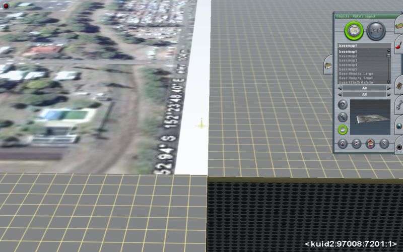
Google earth on baseboard?

Leon740

New member
Hi! Sometimes i see on this forum that people use google earth grounds as baseboard. How do you do that and is it possible in trainz 2010?

many thanks :)
 
Basemap A-Z & 0-9

Trainzoption file add the line: -surveyorfov=185 (and it is changeable from numerals 55 to 185), for a wider angle, distant, looking straight down, fish eye view, for easy manipulation of Basemaps. Save 1 Km x 1 Km, GE images as a 1024 x 1024 jpg and edit (copy+Paste) onto "Basemap A Square Image" using MS Paint or free Irfanview. you can make hundereds of clones of BasemapA and rename them. I have mine labeled Basemap's 1 through 200
===================================================================================================================
I run TRS2006, by changing and adding the line(s) to -windowed and -surveyorfov=185, -freeintcam, and -intro=disable in the Trainzoptions file.

And set Trainz to run in the next size down of resolution from what my PC Monitor is running in.

Then I can run TRS2006/Surveyor, slide it out of the way, 1/2 off the screen, and go to GE, or topo maps, or webpages ...etc...like a dual split screen.

Basemaps A-Z, 0-9 are 1 Km x 1 Km images which you paste GE 1 Km square image, using free Irafanview or MS Paint, into the "Basemap A Square" file.

The MS Snipping Tool saves a jpg image to your PC Pictures folder, and is superior and easier to use than the PrtScr key, haggling with the screenshots folder is cumbersome.

The GE Tools have a Ruler/Metric/Line or Path that you can temporarily draw a 1 Km x 1 Km box, to snip.

BTW: I receintly found out that I cam run the CMP-DLH, the Auran Black Pages DLS, and TRS2006 Surveyor, all at the same time, using 1/3 of the screen for each application.
 
Last edited:
There's a very good tutorial in the Trainz Community News:

http://issuu.com/trainzcommunity

I think it was March or April. It was written by Vulcan, a highly respected member of this community. You don't need Gmax to use it, not do you have to listen to any music :)

Note: The Issuu site has a strange way odd displaying big projects. The white dots under the magazine represent every 20 pages. When you start, only the first 20 pages are shown. Click the second dot to get the next 20 etc.

Good luck
 
Last edited:
In many cases, people have employed the use of a payware program known as TransDEM. The software makes digital elevation models (3D) terrain for Trainz and also allows the use of Google Earth photos georeferenced onto the terrain for accurate detail placement. Google "TransDEM" and you will learn all you need to know. I highly recommend the program!!!
 
Hi Leon740,

Basemaps,
basemap.jpg


"Special project item, 720x720 basemap, kuid2:97008:7201:1 to5 (there are 5 maps in this set for multiple use) crop a GoogleMap image (or other) to 720x720m
and save it as a 512x512 (1024x1024 is more detailed) tga image and name it basemap1 , then save it in this folder and overwrite the existing file.
Then import it into Trainz. It appears 1m above the surface,
lower it below ground level and switch wireframe on or off (F9) move and or rotate to suit. "

Available from the DLS.

Hope this helps,

A bit of a "peeve" not getting any feedback from the original poster if any of the info given works.

Cheers,

Bill.
 
Snippet: A bit of a "peeve" not getting any feedback from the original poster if any of the info given works.

I couldn't agree more. I guess it's something that's expected of us!

Oddly, a lot of people don't have email notifications set. If they don't get a reply within an hour, the post gets buried and they never even see these replies.
 
Speaking on Google Earth images for the baseboards... I bought a new computer with Win 7/64 and now Google Earth doesn't work. I either get no globe at all or when the globe does appear I get pixelated terrain.

I updated my graphics driver and tried both Open GL and Direct X with similar results. I even went to the previous release so it has to be something with my computer.

Has anyone else experienced this with the newer 64 bit OS's?

Win 7/64 OS
4 gig's of ram
Dual Core Intel processor
Intel G45 integrated chipset

I have Win7 x64.. Never had a problem with Google earth, I would suspect it has something to do with the integrated graphics.
 
Back
Top