Amazing map of railroads

That website is not limited to the US.
A quick scan showed tracks in (for example) the UK, France, Russia and Australia.

Thanks for the link!
 
On the Model Railroad Hobbyist forums someone posted a map of US railroads... down to individual spurs. This is clearly an amazing resource and can be found here: http://www.openrailwaymap.org/

Thank you very much for that link. This is such a great resource for Trainz route builders. It even shows obsolete rail lines in places you would not know existed, like Bermuda or Turnchapel near Plymouth UK.

Cheers,
Roy3b3
 
I feel this is a great find as I have an itch to create a Boston to NY route themed around the ALCS. Something like this will be a great help along side google maps/earth for trying to keep it realistic.
 
Yes it is very good though in fact has been around for a while. When I last tried it the scrolling wasn't working that well but tested just now and seems to be working. Useful in identifying where old railways ran as many of these aren't shown on Open Street Map or in some cases have been removed.
 
WELL great. I was going to be productive for the next few days but now I have this! Arg!


But yes this is amazing and with sites like this: https://bridgehunter.com/ you can also figure out what the bridges look like on the abandoned (or not so) lines!
 
Thank you for this awesome link.

It's sad to see so many abandoned lines though in my area including some I didn't even know about, yet it's cool to see some historical ones marked out which disappeared in the earliest years of railroad building too.
 
What is very interesting is to look at the areas that have rail and those that don't
world of rail.JPG

After Europe, most of North America, India and Japan, there are only scattered areas with any visible rail network showing.

Too bad this couldn't be used as is to create a Trainz map.
 
Combining that website's map with TransDem... that would be funny / interesting.
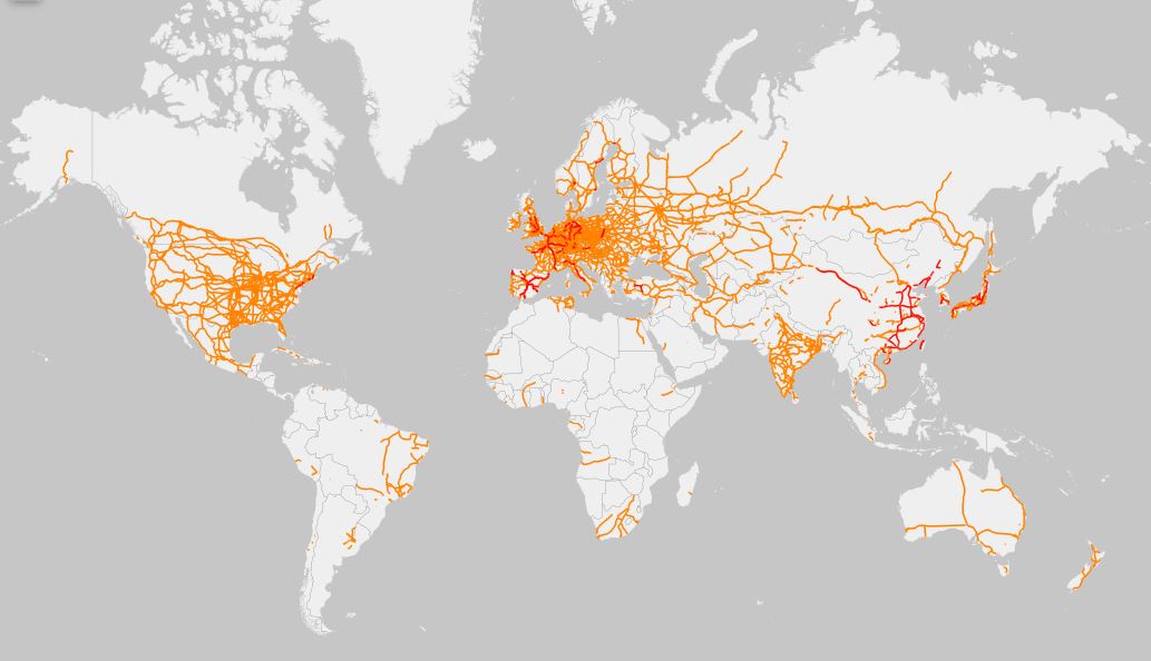
Open Railway Map shares resources with OSM. They explicitly mention the OSM standard vector editor JOSM. Via JOSM and the gpx file format, vector data transfer to TransDEM should be possible.
 
After Europe, most of North America, India and Japan, there are only scattered areas with any visible rail network showing.
Depends on zoom level. Zoom in and you will find much more. Zoom dependent aspects may be things like standard gauge vs. narrow gauge. "Standard gauge" varies by country. In the and it's all down to attributes, ask the OSM folks. Anyway, I spotted my own OSM contributions which I had made occasionally in the past, in some rather remote places on this planet, like Burma, Eritrea or Madagascar.
 
It's not infallible. The Caterham line (UK) off the Brighton line alternates between single and double track on this map, whereas it is double all the way in reality.
 
It's not infallible. The Caterham line (UK) off the Brighton line alternates between single and double track on this map, whereas it is double all the way in reality.

I noticed some things like that as well and also the names of the routes as well. Instead of saying Pan Am Railways Freight Main, the map will say Freight Main. Okay for which railroad? I know of course but not other people.

All and all it gets pretty depressing when you zoom in on places like New Maine, New Hampshire, York state, Pennsylvania, and Connecticut. Many of these lines were active when I was young and now closed and mostly when Conrail and Guilford took over the operations.

I would say that with redundant lines this makes sense, but not some of the through lines. Guilford was famous for this because they were not part of the Freight Main. They went as far as to deliberately discourage business and use then use that as an excuse to force the abandonment of the lines.
 
Back
Top