1887 Mountain Subdivision of the Canadian Pacific Railway

Cayden

Trainz PC, iPad and Mac
Construction of the Canadian Pacific Railway (CPR), its Mountain Subdivision, and the decade following its completion in 1885 is perhaps the most interesting period in the railway’s history.

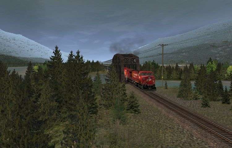
The section through the Kicking Horse Pass in the Rockies and Rogers Pass in the Selkirks was the last section to be completed. By the time of its construction the CPR was running out of money. So this section, in particular, was built quickly and inexpensively to get the railway into a revenue generation position as soon as possible. Blasting, tunneling, cuts and fills were kept to a minimum. As steel was expensive and not readily available and masonry construction time consuming, the abundance of timber along the route was used instead for construction including some massive trestles.

To represent this period in the CPR’s history I have chosen the year 1887 to model (MBC 1887 TS 12 route). The year 1887 allows me to model the spectacular wooden trestles, which deteriorated rapidly and thus had to be replaced within the decade following the completion of construction.

This website has been established to allow me to post pictures along with some of the history I have had access to that supports my interpretation of the route in this era. For additional information visit:

http://www.doug56.net/MBC_1887_TS12_Route/

I will also compare the route with the year 2010, for which the Trainz route in early fall (Trainz 2010 and TR12) is already available on my website. Once the 1887 version of the route is complete, it will also be posted my website.

Cayden

188703750.jpg

The abundant timber along the route of the railway through the Rocky and Selkirk mountains was used to construct the railway thus saving on the cost of construction.

188704750.jpg

In the 1880s there was little in the way of mechanical equipment available so most of the construction on the railway was done by hand. Here a donkey engine is being used to load flat cars with freshly cut timber.

188705750.jpg

A tote road was constructed in advance of the railway so that construction could occur simultaneously at several locations. Bridges, tunnels, fills and cuts were constructed before the grading and subsequently the track-laying crews arrived.
 
That looks like something which deserves attention.
Cool idea, good luck for your endeavour. Looks promissing already!
:)

p.s.: keep an eye on that Wheelspur spline, it needs to be lowered a bit as it is floating in its default setting. :)
 
The Laggan Hill

kickinghorsepass750.jpg

Looking west up the Laggan Hill towards the Kicking Horse Pass.


lagganhill1887750.jpg

Climbing the Laggan Hill westbound to the Kicking Horse Pass in 1887.


lagganhill2010750.jpg

Climbing the Laggan Hill westbound on the North Track in 2010. Note the parallel steeper original track now known as the South Track used for eastbound traffic.

For more on the Laggan Hill see:

http://www.doug56.net/MBC_1887_TS12_Route/page76.html


Cayden
 
Stephen Siding

Stephen Siding was named for George Stephen (Lord Mount Stephen), the first president of the CPR.
He oversaw the monumental task of not just negotiating a 2,000 mile (3,218 km) route across muskeg and
rivers, through forests and up mountains, but also the raising of an estimated at $100 million, to build the
world’s second transcontinental railway.

stephensiding01750.jpg

Stephen Siding in 1887 looking east towards Bath Creek.

stephensiding02750.jpg

Stephen Siding in 2010 looking east towards Bath Creek. An empty unit coal train ascents the North Track,
which replaced the siding at Stephen Siding. The community which once existed is long gone.

The western end of Stephen Siding had a wye for turning helper locomotives used for both extra power on the
ascent and for additional braking on the descent of the Laggan Hill. The wye was removed in 1955.

stephensiding03750.jpg

The wye at the west end of Stephen Siding.

For additional information visit:

http://www.doug56.net/MBC_1887_TS12_Route/page82.html

Cayden
 
Last edited:
In the yearrrr 1887 2010

This is sure looking impressive!

I really love those comparison shots between 1887 and 2010. Really gives a good view of the changes and the quality of the route!

Keep the shots comming ;).
 
Hector Siding

In 1858 Dr. James Hector (now Sir James Hector), surgeon and geologist with the Palliser Expedition, travelled
east up the Kicking Horse River to become the discoverer of the Kicking-Horse Pass, also known as Hector Pass.
In his honour, the siding just west of the summit was named Hector Siding. Today the siding is long gone
but there is a cairn at the summit commemorating Sir James Hector’s exploration and discovery of the pass.

hectorsiding01750.jpg

Hector Siding in 1887 looking east from Wapta Lake.

hectorsiding02750.jpg

Hector Siding in 2010 looking east from Wapta Lake. Although not visible in the picture, the siding is long gone.
A more substantial bridge has replaced the original trestle. The Trans Canada Highway is in the foreground.


For additional information visit: http://www.doug56.net/MBC_1887_TS12_Route/page83.html

Wondering about the forest fire? See the next installment.

Cayden
 
Forest Fires

Forest fires were, and are, a yearly occurrence in the mountains of British Columbia as soon as dry weather
sets in, causing a greater or less destruction of valuable timber according to their extent and duration.
In the 1800s the fires burned from spring to autumn and were only completely extinguished when there was
sufficient snow cover.

forestfires01750.jpg

The aftermath of the1886 forest fire in the Kicking Horse Pass with Wapta Lake in the background.

forestfires02750.jpg

The Hector Siding water tower and section house destroyed by the fire of 1886 were rebuilt.

For additional information visit: http://www.doug56.net/MBC_1887_TS12_Route/page84.html

Cayden
 
Last edited:
Caydon: I Think your project is great..Your Pics and comparison is outstanding..Keep up this great work..
 
The Big Hill

While the ascent to the Kicking Horse Pass from Laggan was challenging, the descent from the Summit if the
Kicking Horse Pass in the Rocky Mountains to Field was dramatic. Following two comparatively level miles
from the summit the Kicking Horse River plunges 1,142 feet (348 m) in two miles (3.2 km).

The solution finally adopted was to ask the Government of Canada for a dispensation on the maximum grade
agreed to, and build a temporary track with a 4.5 % grade directly down into the Kicking Horse River valley.
This became known as the “Big Hill” and, although originally intended to be temporary, lasted in service for
25 years.

bighill03750.jpg

Descending the 4.5% grade of the Big Hill.

Operating on the 4.5 mile (7.2 km) 4.5 % grade was hazardous. The track at the front of the locomotive of a
five-car passenger train was sixteen feet lower in altitude than that at the rear of the last passenger car.

bighill11750.jpg

An ascending passenger train approaches the second crossing of the Kicking Horse River on the Big Hill.
Today the Trans Canada Highway follows this portion of the Big Hill.

bighill05750.jpg

The Trans Canada Highway descends the eastern portion of the Big Hill and its 4.5 % grade. The last Howe
truss bridge over the second crossing of the Kicking Horse River, now referred to as the Old Bridge, still stands
beside the highway.

For additional information visit: http://www.doug56.net/MBC_1887_TS12_Route/page85.html

Cayden
 
Mount Stephen House

Hauling heavy dinning cars over the Kicking Horse Pass and Rogers Pass presented a problem, particularly on
the Big Hill with its 4.5 % grade. The CPR solved this problem by building three hotels; Mount Stephen House
at Field in the Rockies, Glacier House at Rogers Pass in the Selkirks and Fraser Canyon House at North Bend
in the Fraser River valley north of Vancouver.

Passengers travelling westbound on the Pacific Express had breakfast at Mount Stephen House in Field, lunch
at Glacier House and supper at Fraser Canyon House. For eastbound passenger on the Atlantic Express the
opposite occurred.

mountstephenhouse01750.jpg

Approaching Field from the east in 1887. Mount Stephen House is seen front and center with Field Station in the
foreground. Mount Stephen is on the left in the background.

mountstephenhouse02750.jpg

Approaching Field from the east in 2010. The bunkhouse for train crews is above the green Province of
Saskatchewan grain car in the center of the photograph. The Trans Canada Highway in the foreground is on
the opposite side of the Kicking Horse River from Field. The bridge connecting Field can be seen on the far left.

For additional information visit: http://www.doug56.net/MBC_1887_TS12_Route/page86.html

Cayden
 
Field

Field was named after Cyrus Field, head of the Atlantic Telegraph Company, which laid the first trans-Atlantic
communications cable in 1858.

The CPR built a turntable and roundhouse at Field. The turntable was originally turned by hand. Later on,
compressed air from the locomotives, and still later electricity, were used to power the turntable.
An adjacent roundhouse was used to store and maintain the fleet of helper locomotives that assisted trains
over the Big Hill. The roundhouse was expanded and upgraded over the years. The last of the roundhouses at
Field was torn down in 1988 and the foundations were buried in 1993.

field01750.jpg

Field yard looking west in 1887. The roundhouse can be seen in the center of the photo. The main street
paralleled the tracks next to the Kicking Horse River.

field02750.jpg

Field yard looking west in 2010. The town is now located up on the slope to the left in the photo.

For additional information visit: http://www.doug56.net/MBC_1887_TS12_Route/page87.html

Cayden
 
I especially like the "Big Hill" trackage on your old time route !

There was a tunnel somewhere nearby (and still is there), that was also abandoned, in lue of the new alignment grade.

Have you ever watched the Pentrex video: "BC Kicking Horse Pass-Spiral Loops Tunnels" ? Fantastic cab ride !
 
Locomotive #314

314onturntableatfield75.jpg

This scene was recreated from a photo of the second incarnation of locomotive 314, on the turntable at Field
in the early 1890's (see link).

http://www.flickr.com/photos/glenbowmuseum/5853152644/lightbox/

Note the 45° beam used to hand turn the turntable, just visible in the lower right of the original photo.
Some of those pictured may have been crew that lost their lives in the 1894 explosion.

For additional information visit: http://www.doug56.net/MBC_1887_TS12_Route/page88.html

Cayden
 
Last edited:
I especially like the "Big Hill" trackage on your old time route !

There was a tunnel somewhere nearby (and still is there), that was also abandoned, in lue of the new alignment grade.

Have you ever watched the Pentrex video: "BC Kicking Horse Pass-Spiral Loops Tunnels" ? Fantastic cab ride !

Thanks for the reference to the Pentrex video. I wasn’t aware of it.

I have been using Highball Productions #177 cab ride to add detail to the 2010 version of the route. However,
the video covers only Field to Revelstoke, so I have not been able (till now) to view the Spiral Tunnels and
Kicking Horse Pass. Thanks to your reference, I have ordered the Pentrex video and will have a look at also
updating this part of the route.

ottertailbridgeoriginal.jpg

Here is a shot of the bridge across the Kicking Horse River at Ottertail Siding from the current version of the
MBC 2010 route.

ottertailbridge2010revi.jpg

Here is a shot of the bridge across the Kicking Horse River at Ottertail Siding detail corrected according to the
Highball Productions #177 cab ride.

siteofcorytunnel2010ori.jpg

Here is a shot of the site of the Cory Tunnel at mile 25.75 from the current version of the MBC 2010 route.

siteofcorytunnelrevised.jpg

Here is a shot of the site of the Cory Tunnel detail corrected according to the Highball Productions #177 cab
ride. A cut now exists (no tunnel).

corytunnel1887.jpg

Here is a shot of the site of the Cory Tunnel in the 1887 version of the route under construction. The original
470-foot tunnel through clay took five months to construct because it collapses twice during construction.
In 1887 it had to be abandoned entirely for a sharp curved diversion around the hillside.

An update to the 2010 MBC route is just about ready to upload to the website. It has many fixes, mainly scenery,
removed troublesome assests, improves map view, added inline cameras, and improved performance.

The winter version is also just about ready to post. It has reduced JVC asset dependence (no grass – its under
3 to 6 feet of snow!). Don’t get me wrong. I think JVC assets are great. Just didn’t need as many to do the
winter version.

Cayden
 
Muskeg Summit

From Field the original rail line climbed 2.3 mile with a ruling grade of 2.2 % to Muskeg Summit then
descended with a grade of 1.88 % for 3.2 miles to Ottertail Trestle. Helper locomotive were required in both
directions.

muskegsummit10750.jpg

Leaving Field heading west in 1887.

muskegsummit11750.jpg

Leaving Field heading west in 2010. Over the years the yard at Field was extended to accommodate long and
longer trains. Today it can accommodate the 100-car plus unit trains which make up the main traffic on the line.

In 1902, the CPR constructed the 8.2 mile long Ottertail Diversion along the Kicking Horse River, eliminated the
Muskeg Summit. The Diversion added 1 mile to the distance between Field and Ottertail but reduces the grade
to a maximum of 1.5%.

muskegsummit12750.jpg

In 1887 a passenger train heads west out of Field towards Muskeg Summit, in the notch just ahead.

muskegsummit13750.jpg

A westbound unit grain train heads west in the Field yard towards the Ottertail Diversion along the Kicking
Horse River.

For additional information visit: http://www.doug56.net/MBC_1887_TS12_Route/page89.html

Cayden
 
Last edited:
Back
Top