Sudety horrible "hills"

garoto

Member
Well as I`m not allowed to post attachments, I beg for your imagination, despite my poor English...
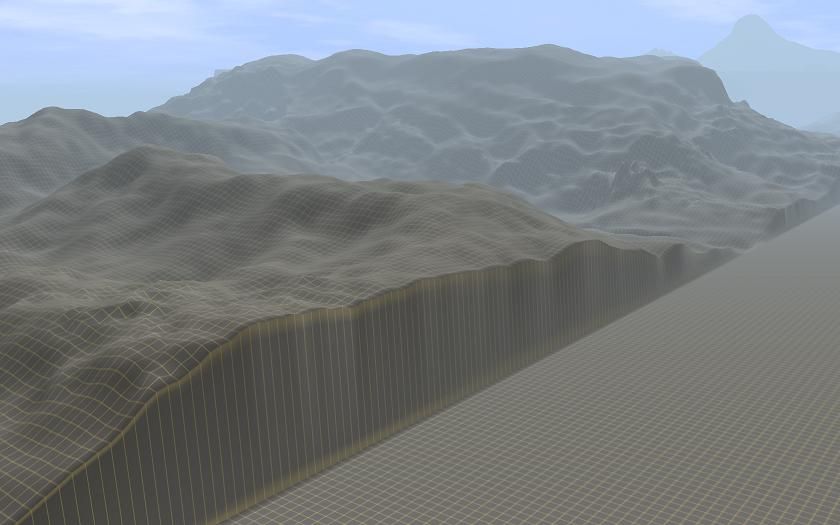
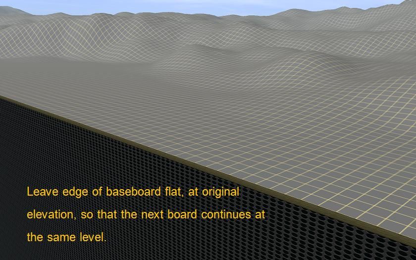
In Projekt Sudety Jesien 76 PL and Beta, I have a problem of horrible elevations and 100m+ punctiform "hills" along some seams between the scenery boards.

Any guess on how to solve it??

BTW, why can`t I post attachments? What must I do to be allowed to it?

Best regards

Walter
 
Well, that is the problem, in "Posting Permissions" says I am not allowed to post attachments.
So , regarding this forum, I have to wait that the forum grants me rights to post attachments, or that someone understands what my problem is.

Thanks anyway
Regards
Walter

BTW... punctiform is as in your dictionary. So I have hills in the format of an arrow... something like this...
 
Garoto

I know what you mean.

To insert a picture into your forum posts, you need to do it indirectly. First upload the image to an image-hosting site (such as Photobucket or HostThenPost or some other one). From that site. copy a link to your image. Then in your forum post (in edit mode), click on the icon in the toolbar (it looks like a picture of a tree) to open a box to paste the link into. This box helps to make sure the link has the right format to show the image itself, and not just the link text.

The pointed hills along the seams between scenery boards are caused by a bug in Trainz (unsolved since at least 2004!!). Sometimes they are hills, sometimes holes. It happens with DEM-based layouts and when boards have been merged together. Maybe someone else here knows how fix this..


.
 
Last edited:
'
Is this what we’re talking about?

baseboardedge_zps63030b84.jpg~original


If so, I thought it was normal. How will the next baseboard know how to link up to the existing baseboard/s when the already built terrain is uneven?

My workaround, I suspect in common with many others, is to leave a margin of flat baseboard at 0.00 ft elevation at the edges, so that any additional boards then match. Adjusting the terrain from natural sloping ground is much easier to do than making good the knife edged stuff in the first screenshot.

baseboardedgeflat_zpsdac85bc4.jpg~original
 
No, as I said, I didn`t merge the routes, it`s as I downloaded from DLS.
It happens only in some places, always along the board seams, and is an elevation, or a kind of a trench in some cases, along a few meters. I`m fixing it in surveyor using topology tools, but the result isn`t perfect and I would like to know the origin of that, and how to avoid it completely, not fixing.
 
Hi garoto,

Yes, this is quite normal and due to where the terrain was cut off at the edge of the world. Where that data ends, the elevation drops back to zero. You can chop back the ground one baseboard row if you want, or you can smooth out the edge as mezzoprezzo has shown here.

John
 
On a DEM sometimes there is a 10m, or 20m, wide, seeming bottomless trench ... I just stitch them up, in a Frankenstein stitch, like needle and tread, every 20m, to 40m, using track ... then hit each progressive track with the smooth spline tool.
 
I see that without a photo I will not be understood and I am fixing the thing via surveyor.
Thanks anyway for the good will in trying to help me.

Best regards

garoto
 
You mean probably this:
http://trainzimage.pl/image/kP
It is error in the map which started in the beginning of building of map several years ago. In TRS2006 map should be without problem, this occures only in higher versions, author recommends to correct it manually somehow.
 
Those, (and bottomless pits) can be easily fixed using a short section of track, applied to each side of the terrain just outside of the monolith, and hitting the smooth spline tool button
 
Back
Top