Problem with TransDEM.

DickTurpin

GWR Man
Does anybody know the SRTM DEM file number for the UK?
I did ask the man at TransDEM what it was and he said it
was W001 or E000 in the 50's, but I've tried them, but I end up
in the middle of an ocean.
Any help would be much appreciated.
Cheers, Dick.
 
As already suggested, follow the path outlined in the Quick Start Guide. Start with the maps. Replay the Map Tiles tutorial, this time focussing on your area of interest.

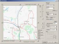
An arbitrary UK example: Kidsgrove, north of Stoke-on-Trent. Acquire your map clippings with the Map Tile client.


You can already have a first glimpse at the coordinates at the top and bottom of the preview window: N53°, W2°

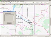
Get one or more clippings as in the Map Tiles tutorial. Return to the TransDEM main window. Coordinates will now be shown in the status bar, in degrees and in projection coordinates. And, miraculously, the "File name info SRTM .hgt" command is also enabled.


It only shows one entry in this small example: N53W003.hgt. Why W003 and not W002 as indicated in the status bar? We are in the Western hemisphere here. By convention, western hemisphere longitudes are negative, so N53W003 stretches from W 3° (western border) to W 2° (eastern border) or -3° to -2° longitude (and also from N 53° to N 54° latitude).
 
There is some hi-res UK DEM in the UK Trainsim file library - you need to be a member and probably take out a £3 one month premium membership as the files are quite big. I believe the uploader provided a coverage map.

Alternatively, you can use the Viewfinder DEM site which also has a coverage map to guide you, though not sure the UK DEM data is quite as good as the stuff at UKTS.

As Roland points out, for most of the UK being west of the Greenwich meridian, you need to increment 1 to a westerly longitude to select the correct packet(s).
 
Vern, the OP is still struggling with the initial challenges, we'd better not confuse him yet with alternative geo data sources.

Nevertheless, as far as I know, this "hi res" UKTS data is some re-sampled standard source and nothing special at all. Please correct me if I am wrong.

To my knowledge, what you can get for free for the UK, without paying a subscription to anyone, is:
  • SRTM 3 arc sec (60 x 90 m)
  • SRTM 1 arc sec (20 x 30 m), quite new, available since end of last year (not to be confused with something unofficial claiming to be SRTM 1 arc sec)
  • ASTER GDEM V2, 1 arc sec (20 x 30 m),
  • O/S Open Data 50m terrestrial (all others are orbital), in my opinion the best of them all.
For TransDEM I would always recommend to download unmanipulated DEM data from the original data source whenever possible, and avoid preprocessed or repackaged data. Any form of preprocessing/repackaging which involves filtering or re-sampling will make the data less accurate. That's math and has nothing to do with the abilities of the preprocessor. The situation may be different for other rail simulations but with TransDEM and Trainz there is hardly a need for external DEM preprocessing or repackaging.
 
Last edited:
Vern, the OP is still struggling with the initial challenges, we'd better not confuse him yet with alternative geo data sources.

Fair comment Roland, it was more to point the OP at sources which do provide a visual approximation of the area coverage.

I've always achieved reasonable results from the UK DEM at UKTS but accept it is quite old now and may have been bettered since.
 
Back
Top