UK Screenshots for Pre BR Blue. High resolution warning.

Seaton Bank Head was the top of the gruelling 1 in 39 climb from Ryhope station and although the box here closed in 1937 through the magic of Trainz it liveth again. I have a copy of a line plan from 1875 and at that time it had a network of sidings connecting with the Rainton & Seaham Wagonway. Here's V2 60975 passing southbound with a diverted passenger train, regular services having ceased in 1952.

V2 at Seaton Bank Head 24.04.24 by A1 Northeastern, on Flickr
I see from the 1896 25 inch to the mile map in the NLS that "The Long Run" of the Rainton and Seaham Railway was present but that it had gone by the time WWI started, with the 1914 survey being published in 1919.
It was not the first, nor by no means the last colliery branch to succumb to closure in County Durham.

Johnson's "North Eastern Steam" (Ian Allen 1989) has a shot of J27 No.65869 taking the gradient at the other end, near Ryhope. The regulator is fully open and the trailing load is around 12 empty 21T hoppers with a brake van. I imagine that it was not a favourite turn for Sunderland shed Firemen.

the same book also has a shot of a hard working snowplough-equipped Q6, No. 63395 with a trailing load of 16T mineral wagons bound for South Hetton Colliery taken between the sie of Seaton station and Seaton Bank Top.
 
Last edited:
xnIzQeo.jpg


I have gone in to my County Durham TransDEM route and rustled up an interpretation of Seaton Bank Top pre-WWI.
A Worsdell T Class 0-8-0 is bringing a trailing load of empty 11, 12 and 17 ton hopper wagons past the signal box.
To the left of the screenshot you can see the eastern end of "The Long Run" from the Warden Law Engine.
On the right of the screenshot are the loops at the top of the bank which ran down to Seaham Colliery and Seaham Harbour.
 
Last edited:
A lot of what I'm doing at the moment is correcting my earlier work. Millfield station was one of my childhood haunts ; it closed in 1955 and when my late father and I walked to the town I was fascinated to know what lay behind the filthy and boarded up windows. This morning I decided to improve it and hit upon the idea of using 4 x Station Building5 by Hiskey underneath "corrugated iron roof end" and it looks a whole lot nicer. The station building was demolished in 1975 and the line closed in 1984 but was reopened for the Metro in 2002.
In real life the fence on the right was made of old sleepers tied together vertically - if anyone knows of one on the DLS please let me know .

Class 108 DMU at Millfield 26.4.24 by A1 Northeastern, on Flickr
 
Last edited:
Nice screenshots, but have you tried using FRAPS or Bandicam, or even steam (if you have the steam version of the game) to capture screenshots in full screen instead of what you're currently doing?
 
Nice screenshots, but have you tried using FRAPS or Bandicam, or even steam (if you have the steam version of the game) to capture screenshots in full screen instead of what you're currently doing?
Or even <Sift> <Printscreen> then paste it into a graphics editor.

John
 
Last edited:
1fRmAt9.jpg


A North Eastern Railway Worsdell P2 Class 0-6-0, later LNER Class J26, begins the descent from Seaton Bank Top in County Durham towards Ryhope and on to Sunderland.
At this time, around 1904, the Durham Coast line is not yet open, though it was getting close to completion.

Lewisner, the only railway sleeper fence I found on the DLS was a horizontal one and it is Australian with no "thickness" to build 3.5.
 
Ivatt 2MT 41241 on the 6:05pm service from Bath Green Park to Binegar. At Bath you can see it is sharing the platform with a brilliantly lit ex-GWR railcar - this would depart shortly behind the Ivatt but instead take the ex-Midland line to Mangotsfield and ultimately Bristol.

IIFQXJD.jpeg


Seen here at 7pm, the Ivatt has run around its train and shunted into platform 2 ready for the return trip. It appears that it has been repainted in fluorescent paint at some point...

XecRzP5.jpeg


Cheers,

PLP
 
Last edited:
Ryhope Colliery Junction was where the line to Hartlepool and Stockton diverged from the Durham Coast Line and there was also a branch to Ryhope and Silksworth collieries. Everything has gone now except for the 2 tracks on the right. I've just roughed in the Silksworth Colliery branch but since I don't have DEMs there's major work ahead.


Trains at Ryhope Colliery Junction 29.4.24 by A1 Northeastern, on Flickr
 
B1 61010 Wildebeeste climbs the bank to Fawcett Street Junction in Sunderland as a Lambton Tank waits to leave the South Dock line heading for her home at Philadelphia (Co Durham). The curve to Sunderland station was closed in 1966 but relaid for the Metro in 2002 ; a new station , Park Lane , covers the whole of this site and the former Park Lane bus station on the left.

Wildebeeste at Fawcett Street Junction 1.5.24 by A1 Northeastern, on Flickr
 
'slightly strange' Annie? I think you've piqued my interest! (goes off to download)
(sigh) Paul, - If you were to build a midland region route complete with sessions by grabbing a random assortment of model assets from all over England and Cornwall and possibly even the US as well when you have little understanding of British practice it's not very likely that you will end up with anything remotely like what you are claiming to have built.
 
Hello Lewisner

You mentioned in an earlier post about getting to grips with a DEM route.
Here is part of my County Durham route, generated in TransDEM, in the vicinity of Ryhope colliery Junction and Ryhope Grange Junction.
A range of screenshots follow from a route in the early days of progress.
There remains an immense amount of work to do here, especially relating to scenery.


NqmReXy.jpg


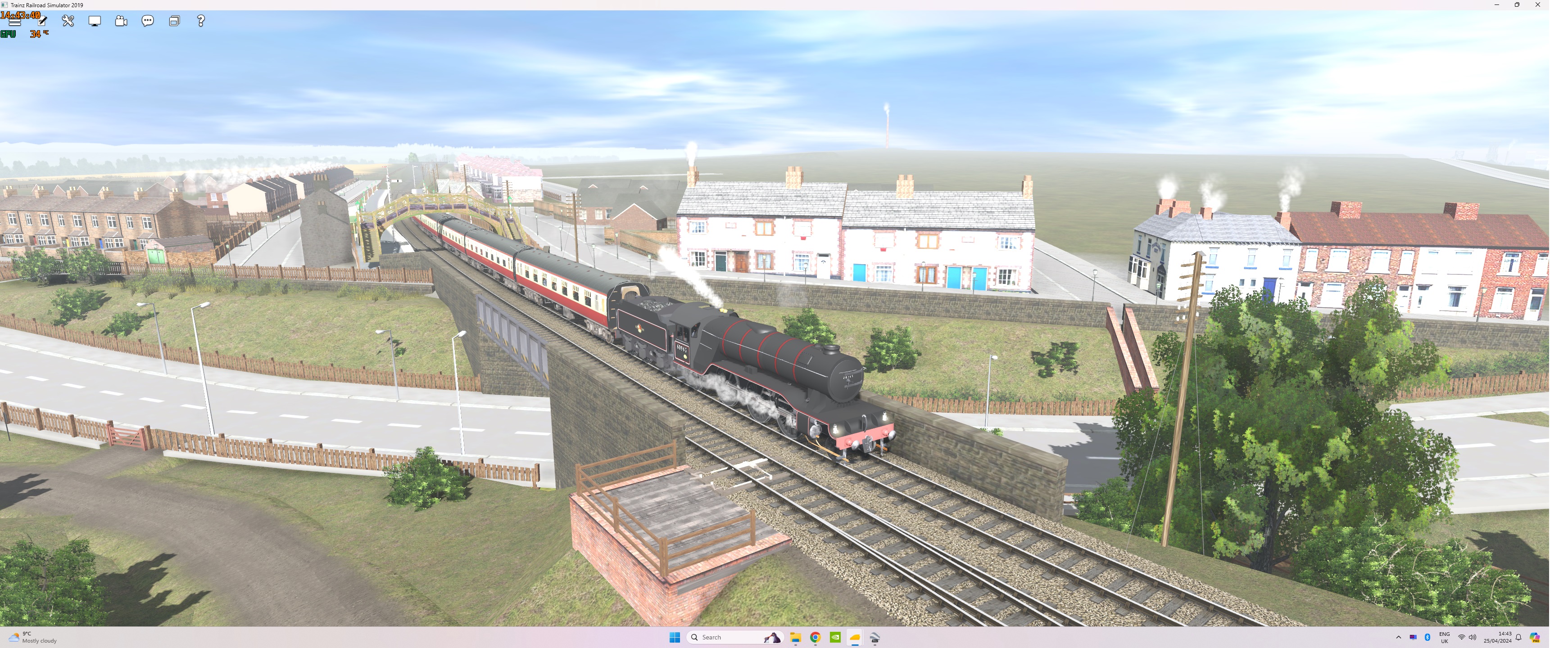
A Raven D Class 4-4-4T on the Leeds Northern Up line heading for Ryhope East station.
It is a 3-set of elliptical roof 49ft ordinary bogie carriages with a strenghener added at its head. It is an older arc roof 49 ft ordinary bogie originally built for the North Tyneside passenger service.
In the background a coal train comes off the Ryhope and Silksworth Colliery branch to join the Sunderland and Hartlepool Down line towards Ryhope Grange Junction, bound for Sunderland docks via the Hendon branch.
You can see the high ground in the distance on the left in the vicinity of Silksworth.


Tu1cQmT.jpg


A shot looking over the two stations at Ryhope with the D Class heading towards Ryhope East.
Seaton Bank Top can be seen in the background on the Sunderland and Hartlepool line, which was the original NER line between the two towns.


oILm5s4.jpg


The Raven T2 0-8-0 hauling the coal train taking the Down Sunderland and Hartlepool line.
On the loco's right, on the left side of the screenshot can be seen "the Durham Coast Line", which technically is the NER Leeds Northern branch.
As you can gather, that line started in Leeds, ran up through Ripon and Northallerton, on through Stockton to West Hartlepool.
For administrative purposes the branch ran all the way to Gateshead via Sunderland, Pelaw and Felling.
Between the two lines can be seen the headshunt which is the northern end of the loop and goods lines at Ryhope.


u9ODXie.jpg


The T2 approaches the southern end of the Ryhope Grange Junction complex, passing over the Down end of the trailing turnout connection.
This move will initially bring the T3 from the Sunderland and Hartlepool Down line on to the Leeds Northern Down line.
Between the two lines is a spur with run around loop.
It has a facing connection from the Up Sunderland and Hartlepool with a trailing connection to the Down Leeds Northern.
My belief is that this allowed a goods or coal train from Sunderland on the Up Leeds Northern to run into the spur alongside the Up Sunderland and Hartlepool, run around it in there and then join the Down Leeds Northern.
from that point it could take either the down Hendon branch or Down Londonderry branch to take it down in to the Sunderland docks complex.
It would not block either of the running lines while the loco changed ends and could also be kept there while higher priority trains passed by.
In the background you can still make out Seaton Bank Top.


je1VfPE.jpg


As the T2 moves through the Ryhope Grange Junction complex it takes the Down Hendon branch towards Sunderland Docks.
With the growth in weight and length of coal trains you can see that this 600 Ton coal train now technically occupies three branches, the loco on the Down Hendon, the middle of the train on the Down Leeds Northern and the brake van on the Down Sunderland and Hartlepool.
Obviously, nothing can move south along the Leeds Northern in this vicinity at the time of the shot.
Coal trains were not timetabled in the NER, they were booked as required overnight when the mineral department received the day's lifting requirements from the collieries.
Train crew literally did not know when they arrived at work exactly how much work there'd be.
Crews earned a bonus based on the amount of coal they hauled, though they were hostages to timetabled trains.
Paths were reserved in the working timetables but mineral trains were at the bottom of the pecking order operationally, despite being by far and away the biggest revenue generator.


iS3QZwo.jpg


The T2 proceeds along the Down Hendon branch, bound for the docks.
In the foreground runs the Londonderry branch, originally built by the company owned by the 3rd Marquis of Londonderry between Seaham and South Dock, where it had its own passenger terminus.
The NER eventually took it over, using most of it to form the basis of its Durham Coastal Line, with construction commencing in 1899.
The coastal line was officially the Leeds Northern branch.

I don't usually post shots with little or no scenery present, so my apolgies for that, but Lewisner, this gives you an idea of what the terrain looks like on the DEM.
 
Last edited:
Hi Borderreiver, those are great shots even pre scenery ! What I actually about DEMs was that although I bought Transdem when its creator was still alive I don't seem to have a mathematical bent so my route was built without using a DEM and couldn't have one retroactively applied since it would probably mean ripping everything apart and moving it. Ryhope Grange is actually where I started building it in about 2005 so it is at height 0.00 ! Although my route is set in a theoretical 1962 I have the NER signalling diagrams for about 1905 and the LSSR diagram for 1879 when it was know as "Half-Way House Junction". I copied these and many others from the original Ministry Of Transport reports in Kew Public Record Office.
Here's a J27 heading from the Durham Coast line onto the the Down Londonderry Line at Ryhope Grange. In the background a train from Silksworth is headed by two Class 03 diesels and will take the Down Hendon Line to South Dock.

J27 at Ryhope Grange 2.5.24 by A1 Northeastern, on Flickr

And a few minutes later passing Grangetown Crossing. The Londonderry line crossing gates were probably installed by the LSSR and had unusually ornate cast iron posts.

J27 at Grangetown Crossing 2.5.24 by A1 Northeastern, on Flickr
 
Back
Top