Kegg_Works
New member
Hey all,
I don't know about you, but one of my favorite things about using Trainz is the Surveyor part of the game. I love to build routes and maps, creating interesting and unique terrain for both prototypical and freelance railroads. However if you are one, like myself, who LOVES mountainous terrain with a twisting, winding right-of-way... you have your work cut out for you when editing the topography of the landscape. And especially so if your line climbs up to a high elevation.
I posted a thread a few months back about installing the HOG textures and program used to generate terrain for maps in Trainz. For the life of me I just can't figure out how to do it, and I don't have enough spare $$$ to invest in one of the more user friendly programs for this purpose. And that's why I've posted this thread.
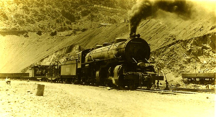
Right now there are two real life routes I have in mind. Both of which wouldn't be terribly large and could probably be used in the same route. Though the one I'm currently fixed on is the Verde Tunnel & Smelter RR. Which ran from Clarkdale, AZ to Jerome, AZ to the West. the line is twisty and winds its way through some VERY rugged, arid terrain and this line also used some hefty 2-6-6-2 Mallets to haul the ore from Jerome to the relocated smelter in Clarkdale. (The smelter was originally in Jerome, but copper deposits were discover directly beneath it. Hence the relocation.) The line also used a number of 0-6-0 switchers to help operate the big pit in Jerome as well as operate at the smelter. Here are some photos of the engines and a photo of one of the many sharp curves along the line.
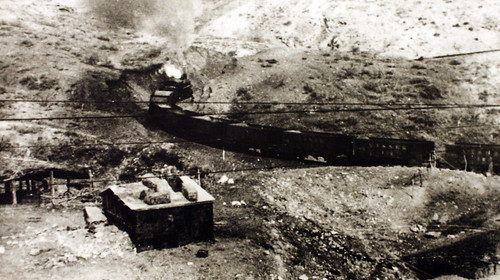
The line closed in the early 1950s, but started in 1920. Which replaced the earlier 3ft gauge line that accessed Jerome. The United Verde & Pacific. (more on that in a minute.) For a standard gauge RR is was a VERY steep and VERY crooked line, wich would make watching 2-6-6-2 Mallets very amusing to watch as the boiler would swing out to the outside of the many curves on the line. Grades I would guess would vary between 2 to 4+%. Again, that's a guess. Only made my looking at the route from Google Earth. Sadly a portion of the old line has been destroyed by modern day activities. So some guesstimation might have to be made as to where the roadbed lines up.
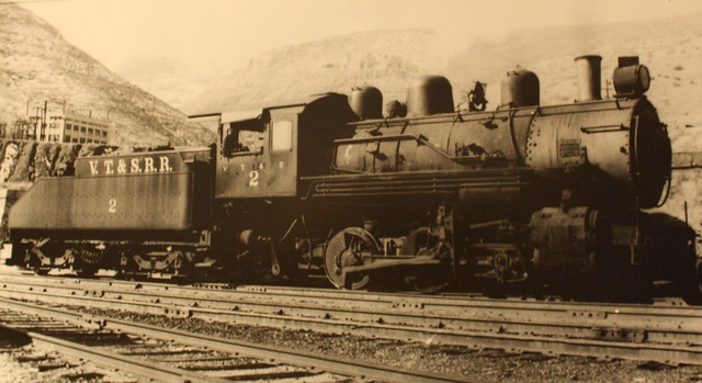
So that's the first idea, the second is the earlier narrow gauge line, the United Verde & Pacific. It was ironically longer, just a touch over 26 miles and ran in an East-West direction. I've heard of a number of railroads claim that they are the "crookedest" RR in the world... but honestly I think the UV&P takes the cake! Although the first half of the railroad is almost strait, with some VERY long, gradual curves. But once you pass the mid-way point, the ROW is all over the place! Following along the rugged and seated slopes of Woodchute Mt. The only engines used on the line were some very husky, chunk, squat little 2-6-0s. The locomotives featured a pair of sand domes that were of equal size to the steam dome. they crowded the boiler so much that the bell was mounted on top of one of the sand domes. Here's a photo below.

As a side note, I think this would make a FANTASTIC model for Trainz!
What is amazing is that Virtually the entire route is still in tact. The line ran from Jerome Jct. (what is today Chino Valley) west to Jerome. I think the reasons for why the line used 2-6-0s exclusively was because of the tight curves. One of which is 140%! It would make an interesting route on its own, but even with both lines featured together could make one interesting operation.
I normally don't make requests, I really don't like to. but I think that if these routes, or even just one of them, would be very fun for anyone. One could easily make their own rendition of the line(s) if they wished if the terrain maps were available.
Thanks for reading and I hope that this will inspire someone!
PS: As another informational note, part of the VT&S's tracks are still in use, by the Verde Canyon Railroad.
I don't know about you, but one of my favorite things about using Trainz is the Surveyor part of the game. I love to build routes and maps, creating interesting and unique terrain for both prototypical and freelance railroads. However if you are one, like myself, who LOVES mountainous terrain with a twisting, winding right-of-way... you have your work cut out for you when editing the topography of the landscape. And especially so if your line climbs up to a high elevation.
I posted a thread a few months back about installing the HOG textures and program used to generate terrain for maps in Trainz. For the life of me I just can't figure out how to do it, and I don't have enough spare $$$ to invest in one of the more user friendly programs for this purpose. And that's why I've posted this thread.
Right now there are two real life routes I have in mind. Both of which wouldn't be terribly large and could probably be used in the same route. Though the one I'm currently fixed on is the Verde Tunnel & Smelter RR. Which ran from Clarkdale, AZ to Jerome, AZ to the West. the line is twisty and winds its way through some VERY rugged, arid terrain and this line also used some hefty 2-6-6-2 Mallets to haul the ore from Jerome to the relocated smelter in Clarkdale. (The smelter was originally in Jerome, but copper deposits were discover directly beneath it. Hence the relocation.) The line also used a number of 0-6-0 switchers to help operate the big pit in Jerome as well as operate at the smelter. Here are some photos of the engines and a photo of one of the many sharp curves along the line.
The line closed in the early 1950s, but started in 1920. Which replaced the earlier 3ft gauge line that accessed Jerome. The United Verde & Pacific. (more on that in a minute.) For a standard gauge RR is was a VERY steep and VERY crooked line, wich would make watching 2-6-6-2 Mallets very amusing to watch as the boiler would swing out to the outside of the many curves on the line. Grades I would guess would vary between 2 to 4+%. Again, that's a guess. Only made my looking at the route from Google Earth. Sadly a portion of the old line has been destroyed by modern day activities. So some guesstimation might have to be made as to where the roadbed lines up.
So that's the first idea, the second is the earlier narrow gauge line, the United Verde & Pacific. It was ironically longer, just a touch over 26 miles and ran in an East-West direction. I've heard of a number of railroads claim that they are the "crookedest" RR in the world... but honestly I think the UV&P takes the cake! Although the first half of the railroad is almost strait, with some VERY long, gradual curves. But once you pass the mid-way point, the ROW is all over the place! Following along the rugged and seated slopes of Woodchute Mt. The only engines used on the line were some very husky, chunk, squat little 2-6-0s. The locomotives featured a pair of sand domes that were of equal size to the steam dome. they crowded the boiler so much that the bell was mounted on top of one of the sand domes. Here's a photo below.
As a side note, I think this would make a FANTASTIC model for Trainz!
What is amazing is that Virtually the entire route is still in tact. The line ran from Jerome Jct. (what is today Chino Valley) west to Jerome. I think the reasons for why the line used 2-6-0s exclusively was because of the tight curves. One of which is 140%! It would make an interesting route on its own, but even with both lines featured together could make one interesting operation.
I normally don't make requests, I really don't like to. but I think that if these routes, or even just one of them, would be very fun for anyone. One could easily make their own rendition of the line(s) if they wished if the terrain maps were available.
Thanks for reading and I hope that this will inspire someone!
PS: As another informational note, part of the VT&S's tracks are still in use, by the Verde Canyon Railroad.