Detroit Regional Rail

RooRocz

This space for rent.
Visit the Freshwater Railway site to learn about Detroit's new commuter rail service!

6325705559_c0090183ca_b.jpg


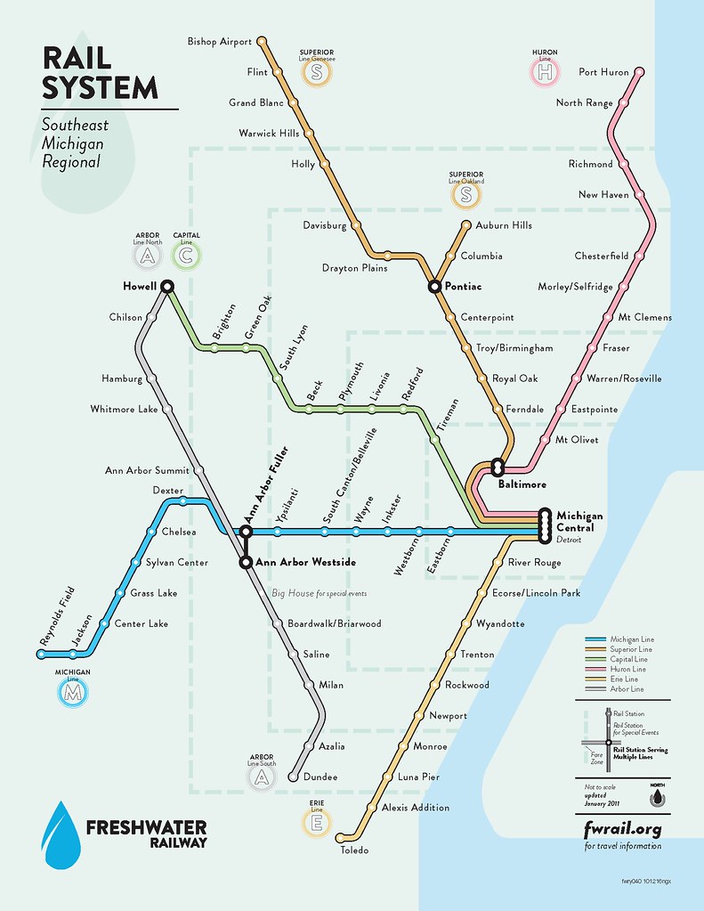
Only one thing: it doesn't actually exist. The meta site explains.

That being said, I think it's interesting how dissatisfied citizens are taking matters into their own hands and creating fictitious transit systems even if politicians have no interest in supporting transit themselves. I hope someone up in the Detroit government sees this website at some point.
 
Or we could just abandon the city and build a giant wall around it and then throw all our prisoners in their and then have guards... oh wait that was a movie... any way, why would you want to live in Detroit?
 
The "Michigan Line" one is under construction. However it'll be known a "MiTrain" and will run from Ann Arbor (either Amtrak or Fuller, if Fuller ever gets built) to Detroit, but the DET Amtrak. the Michigan Central Station is going to cost way to much to fix up for Commuter Rail service.

You can read about MiTrain here: http://www.semcog.org/AADD.aspx

That all being said one of the assignment in my school's Imaging & Illustration class is to make up marketing materials for "Blue Line" which is a fictional Detroit-Chicago rail line.

Also the Ann Arbor line on the above map is another Commuter Line in the works although lately it's been dead in the water. It will (or is) called Wally. However it would stop at a station north of Ann Arbor (not the Fuller Rd. or Amtrak station) as the Ann Arbor Railroad (the company owning the N-S track in Ann Arbor) will not allow passenger service on their line.

Finally how would one get from Fuller to Westside (where the heck would "Westside" be? there is no tracks running N-S on the 'Westside' of Ann Arbor). Generally a station indicator like the used means a free transfer. And while they don'e have it, I'm surprised they didn't put something like this in, one cannot take a train from the Fuller E-W line in A2 the N-S line in A2 without a reverse up a steep, sharp, narrow grade.

peter

Edit: That all being said, maybe I should do up a train for them in TRS & send 'em some pics :D

peter
 
Last edited:
Since when did this happen? Why have I, as a citizen of the State of Michigan, not been informed of the spending of the government?

But hey, yeah I'm for it.

Now we need to ressurect rail from Muskegon to Coopersville, upgrade the Coopersville and Marne, and set up a line from "coast to coast"! Lake to Shining Lake! (Michigan whould be shining, not Erie, from what I heard it could have caught on fire at one point :p ) What to call it, the Furniture City/Automobile City Combination Special? (yes the Furniture City Special was a real train, operated by the Pere Marquette from Chicago to Grand Rapids)
 
Since when did this happen? Why have I, as a citizen of the State of Michigan, not been informed of the spending of the government?

MiTrain or Freshwater?

Freshwater is fully fictional, and so actually hasn't happened.

MiTrain (and Wally for that matter) are both projects primarily being funded thru the local SEMCOG governments such as A2, Ypsilanti, & Detroit. Surprisingly (at least to me) the municipality most 'gun-ho' about MiTrain seems to be Ypsi. I belielve most state money going towards the project is technically going towards the Wolverine no the commuter line, but the both will use the same track & facilities so MiTrain does get some of the State & Federal Money. The biggest item to support MiTrain to happen lately is the purchase (or finalization of the plans to purchase) a big section of the Michigan Line from NS. By the end of the year (so I've read) MI DOT will own the line from KZoo to Ypsi (or maybe Romulus) and Amtrak already owns the line from the state border (with IN) to KZoo.

peter
 
To RooRocz - excellent map

I want to compliment you for the excellent quality of the map and I wonder what software you used.

I have been fooling around creating transit maps for my Trainz routes using Inkscape, which is an open-source vector graphics program.

http://inkscape.org/

Let us know what you used.
 
Last edited:
I want to compliment you for the excellent quality of the map and I wonder what software you used.

I have been fooling around creating transit maps for my Trainz routes using Inkscape, which is an open-source vector graphics program.

http://inkscape.org/

Let us know what you used.

It looks like an Illustrator creation to me. However most of that is from reading the web pages where the creator mentions the tools he used. However I can also tell you that the font being used is Richmond.

peter
 
I want to compliment you for the excellent quality of the map and I wonder what software you used.

I have been fooling around creating transit maps for my Trainz routes using Inkscape, which is an open-source vector graphics program.

http://inkscape.org/

Let us know what you used.

I used Firefox to copy the URL, and the forums software to post it here. Some other guy did everything else.
 
GAAAAAHHHHHHHHHHHHH!

)*&^*&%%$@@%*(&*&%*%#$&#&^%()*&%$@@!%^

You had me there for 18 hours! How dare you smash my dreams of people starting to get smart????????

But I'd still like to see "Coast to Coast"!
 
Back
Top