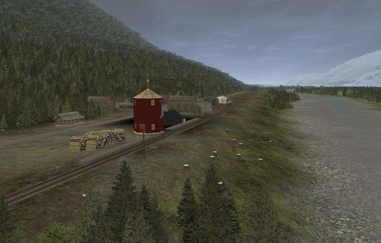
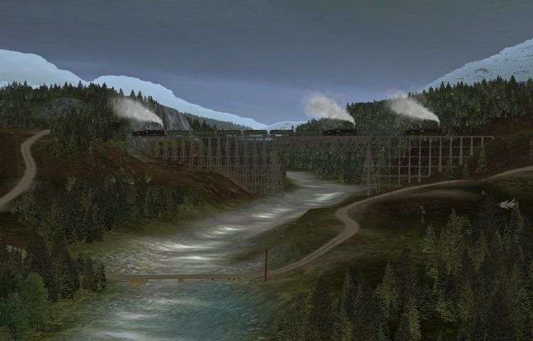
1887 Mountain Subdivision of the Canadian Pacific Railway

Ottertail Trestle

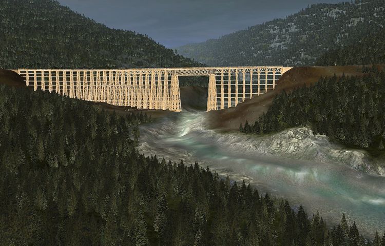
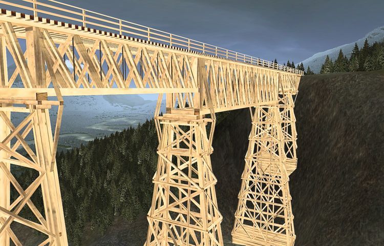
Ottertail River flows out of the Emerald Range to the east. To traverse it the CPR had to build a trestle 705 feet long
and 122 feet high. For its time the trestle was a technical as well as an aesthetic masterpiece. To save money
and to compete the railway in as little time as possible to avoid bankruptcy, the CPR used the abundant timber in
the surrounding forests recognizing that the structure would be high maintenance and would have a short life span.

ottertailtrestle01750.jpg

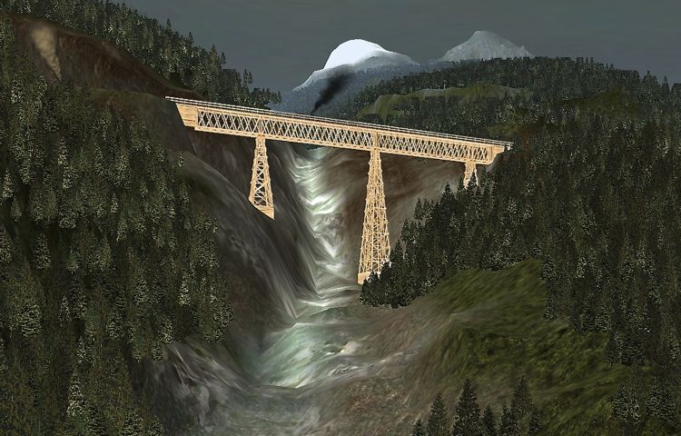
Approaching Ottertail Trestle from Field in 1887 with the Emerald Range in the background.

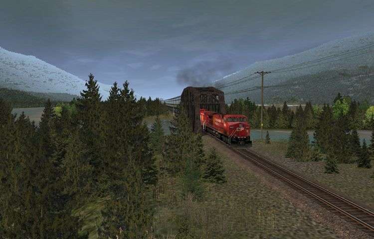
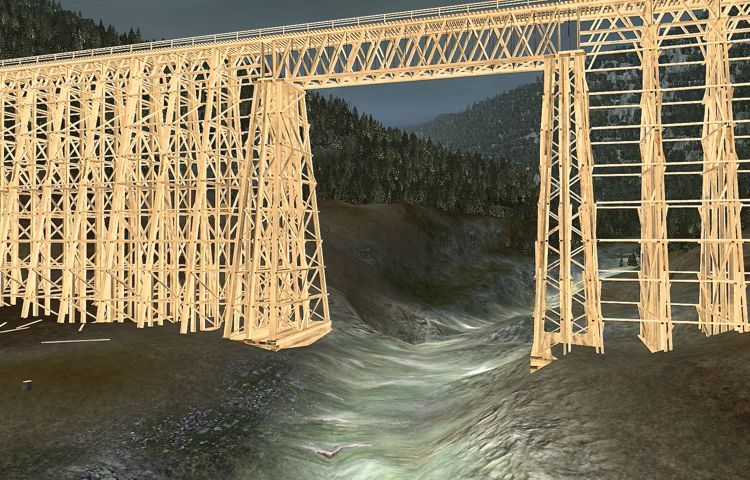
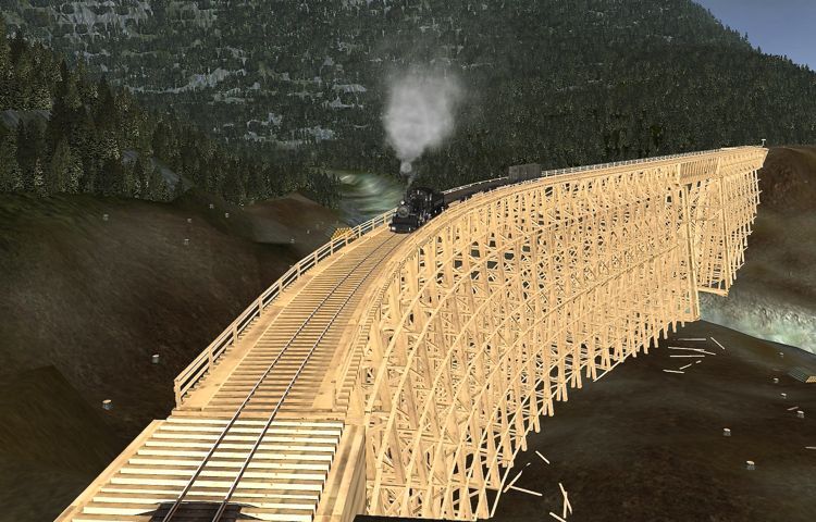
The Ottertail Bridge featured a single Howe truss span in the center over the river itself framed on either side by
towering trestle works.

ottertailtrestle02750.jpg

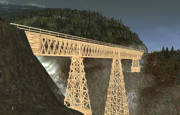
Ottertail Trestle over the Ottertail River.

The CPR dismantled the bridge in 1922 salvaging 295,000 board feet of timber. A back road leading west
from Field follows the original railway grade to the site of the Ottertail Trestle. The earth works of the
original trestle can be seen east of the much less spectacular plate girder bridge used
today on the diversion.

ottertailtrestle03750.jpg

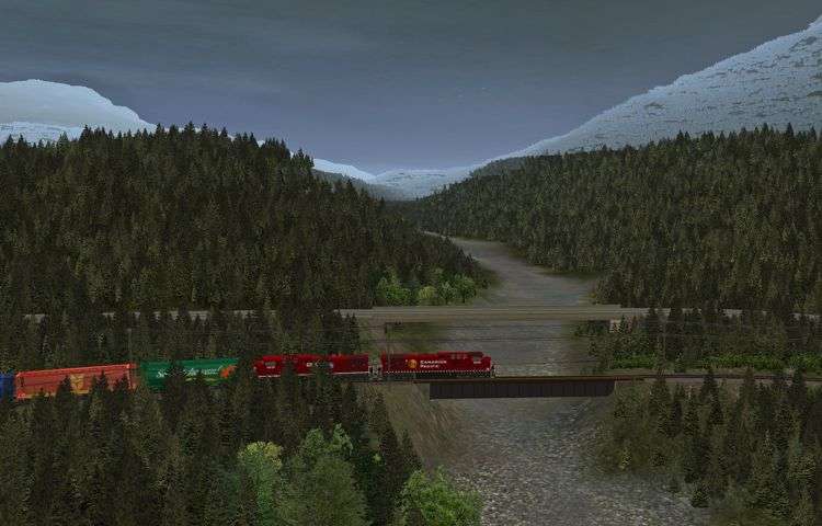
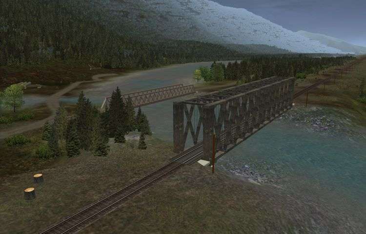
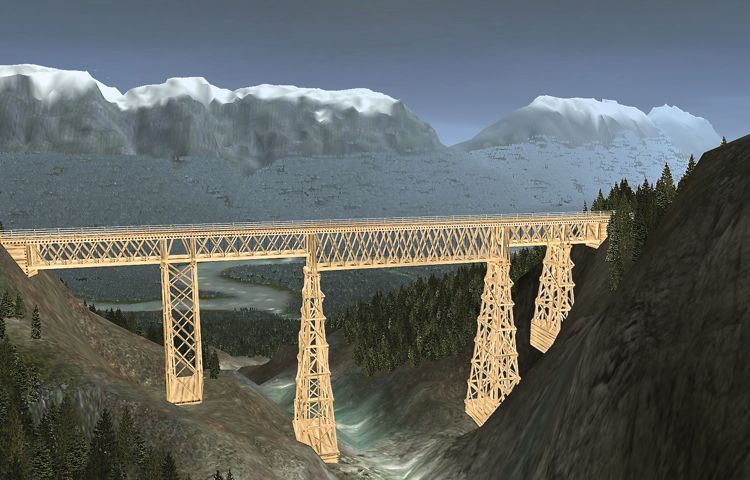
The plate girder bridge over the Ottertail River on the Ottertail Diversion is still in use today. Shown is the
Trans Canada Highway Bridge in the background, and still further back the site of the original Ottertail Trestle.

For more information visit: http://www.doug56.net/MBC_1887_TS12_Route/page90.html

Cayden
 
Last edited:
Remarkable screenshots in your link !

I hope you keep the old trackage in place, for historical fun, running up and down the "Big Hill" !

The modern present day trackage is really nice, but I like the old time feel of this route.
 
Ottertail

Ottertail was likely established as a typical construction camp and likely lasted only a short time. As railway
construction advanced, the camps were periodically moved closer to the end of track. Tents, commissary,
work equipment, horses and wagons, personal gear, engineering supplies and equipment, were all relocated.

thfg.jpg


The bridge south of Ottertail over the Kicking Horse River was likely a Howe Through-Truss bridge similar to other
through-truss bridges further down the valley. Some of these had wooden cribbing in the riverbed, which probably
didn't stand up long against the spring ice jams.

ki9u.jpg


In the #177 cab ride (Highball Productions) the bridge is now a steel Warren through-truss bridge.

ottertailbridge2010revi.jpg


For additional information visit: http://www.doug56.net/MBC_1887_TS12_Route/page91.html

Cayden
 
Leanchoil

jniy.jpg

Leanchoil 1887.

Leanchoil was named after Lethna-Coyle Manor in Scotland, where the mother of Lord Strathcona resided. Donald A. Smith, later Lord Strathcona, was a co-founder of the CPR along with his cousin, CPR president George Stephens. Throughout 1884-85, when financing the CPR became increasingly difficult, Smith and Stephens pledged their homes, their investments, and their holdings in the St Paul, Minneapolis and Manitoba Railroad as collateral and took money from their own accounts to provide operating funds.

Today, like Ottertail, there is only a passing siding, a short siding to accommodate bad orders and snow removal equipment. The only structure appears to be a communications tower.

For additional information visit: http://www.doug56.net/MBC_1887_TS12_Route/page92.html

Cayden
 
Last edited:
Palliser

tru1.jpg

Palliser 1887.

Palliser, a construction camp and siding in the 1880s, was named after Captain John Palliser who led the Palliser Expedition between, a scientific exploring mission of British North America conducted 1857 and 1860. Prior to this expedition the American government had sponsored surveying expeditions that crossed the border into British territory in western North America. Eager to solidify their hold on the west, the British government funded the Palliser Expedition.

For more information visit: http://www.doug56.net/MBC_1887_TS12_Route/page93.html

Cayden
 
Beaver River Valley 1887

If you have travelled up or down the Beaver River Valley east of Rogers Pass and the Connaught or Macdonald
Tunnels in 2010 (the route is available at http://www.doug56.net/MBC) you may have wondered what the route
through the valley was like when it was constructed in 1885.

Heading west, the railway leaves the Columbia River a short distance beyond Beavermouth and commences its
ascent to Rogers Pass. The entrance to valley was by way of the Beaver Canyon, a narrow gorge through which
the Beaver River tumbles to the Columbia. Most of the rock is of an unusually hard nature. In addition the
irregular nature of the sides of the canyon made construction difficult. In one case the track had to be carried
over an elbow of the stream by a short Howe span, which was soon replaced by a retaining wall soon after the
line was opened. The Beaver River was crossed at the upper end of the canyon by a Howe truss bridge on crib
piers, with trestle approaches.

The first part of the climb from Beavermouth up the Beaver canyon is by a grade of 1.5%, or about seventy-five
feet to a mile. A short stretch of comparative level ensued, until Six Mile Creek was crossed, when the ascent of
the pass commences in earnest. The grade from Six Mile Creek, until the summit, twenty miles farther on, was
almost continuous at the rate of 2.2%. Numerous ravines had to be crossed on trestle bridges, some of the most
spectacular trestles on any railway at the time.

For the most part they crossed streams, which much of the time have little water flowing down them or, indeed,
may be perfectly dry. But during spring thaw they become raging torrents sometimes carrying slides of snow
and mud. In the early years one trestle had to be replaced six times and another (likely Surprise Creek) was
liable at irregular intervals to bring down a torrent of semi-liquid mud, which would sweep out anything
moveable in its path. The stream takes its rise in a small lake up the mountainside, which seems to fill up with
mud building a sort of dam across the creek. When the water succeeds in destroying this dam, the whole
accumulation sweeps down the gulch.

Mountain Creek Trestle

The first of note was Mountain Creek Trestle. The central Howe truss over the creek was 150 feet long.
On either side were smaller 30-foot trusses. In all it was 1,086 feet long and 164 feet high and required
over 2 million board feet of timber making it one of the largest timber structure in the world at the time.


Mountain Creek Trestle 1887 looking north up Mountain Creek.


150 foot Howe truss over Mountain Creek.


Train approaching the western end of Mountain Creek Trestle heading up the Beaver River Valley towards
Rogers Pass in 1887.

Mountain Creek Trestle was replaced in 1902 by a steel structure consisting of 100-foot lattice trusses on steel
towers, with 40-foot plate girders over the tops of the towers. Large deposits of gravel nearby were used to
fill in the cut. Strong jets of water were directed at surrounding deposits of gravel undercut the material and
allowing it to fall into sluice-boxes. It was then washed to the fill site. In total 230,000 yards of fill was moved
in this way reducing the required length of the steel span from 1,086 feet to 585 feet.

Surprise Creek Trestle

Surprise Creek Trestle was 430 feet long and 164 feet high. It was made up of three Howe trusses on high
wooden towers. It was so named because of the suddenness with which it appeared on the line.


Surprise Creek Trestle, 1887.


Surprise Creek Trestle 1887 looking up the Beaver River Valley towards Rogers Pass.

A 300 foot steel arch bridge replaced Surprise Creek Trestle in 1894.

Stoney Creek Trestle
Perhaps the most remarkable trestle was the Stoney Creek Trestle. Although it was only 490 feet long, it was
292 feet high making it the highest wooden structure in the world at the time. The trestle consisted of a
continuous Howe truss of four spans from east to west: 33, 161, 172 and 86 feet, respectively.


Stoney Creek Trestle the highest wooden structure in the world in 1887.


The Stoney Creek Trestle consisted four continuous Howe trusses.

Stoney Creek Trestle was replaced in 1893 by a 336 foot steel arch bridge that was built around the wooden
trestle so as to minimize disruption in traffic on the rail line.

For more information visit: http://www.doug56.net/MBC_1887_TS12_Route/page98.html

Cayden
 
Back
Top