Japan

If you look at the area shown in the map on Google Earth and/or Google maps, there is a wealth of really good scenery that could be included - as well as one small line that branches out near Anzen that reaches to the Showa Shell Oil storage area, but that would be industrial and not passenger service.

You would probably need quite a bit of custom content made for this effort. I'd help, but I am all thumbs and toes at making content. I do tracks/texturing/gradients well, however.

Bill
Well the thought for me atleast was that we might do a BETA version first wich is basically consisting of placeholder buildings... and in the final version someday make it realistic till the full version
 
Good idea. We did quite detailed areas on the DHR, mostly famous places, but the remainder we filled in with buildings that gave the "look and feel" of India, but not actually copying everything. That would work admirably with your plans, I'm thinking.

Basically, I'd imagine you'd need correct stations (some of which are curved), proper catenary, and bridges. But, I agree, the rest could be generic.

You all have a good plan.

Bill
 
I did start today at the basemap. Just had an 11 hour session (oops :eek:
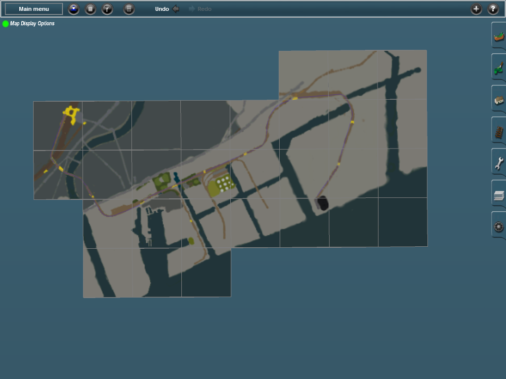
). I got the area of the 3 branchelines 95% finished. I also layer a reference track so that I could measure if the distance is correct. Made it to Ogimachi. The last section has some scaling problems which I'm gonna look into tomorrow. So far pleased with the progress. Basemap is up this week so the next person can take over with the track work.

As I've said. The track that is now in the route is a reference track. You can of course replace that. Also it is now single track while the real route is double and of course there are no yards now etc. But I leave the reference route in so that the next person don't have to guess where the main line is.
 
Today I've sent the basemap of the new Tsurumi Line System Route to TheNicofabi.

Here is a screenshot of the map so far.
If you are a member of the group that is building this route and you want the map now then please send me a message. Otherwise wait till you are asked to build further.

map.png


Yellow are the stations (the approximate locations). In the left above corner Tsurumi Station along the Tokaido Main line can be seen. Also the Keikyu line is there. All three branches are marked. The route and map are flat now. There is no elevation nor water added. The longest branch of the line is exactly 7 km as in real life. The only thing that needs to be tuned is the distance between Musashi-Shiaishi Station and HamaKawasaki. Wikipedia states that HamaKawasaki is 4,7 km from Tsurumi and on my map it is about 4,3 km away while the whole length of the route is still 7 km. Don't know if Wikipedia is entirely correct on that distance.
 
Last edited:
Today I've sent the basemap of the new Tsurumi Line System Route to TheNicofabi.

Yellow are the stations (the approximate locations). In the left above corner Tsurumi Station along the Tokaido Main line can be seen. Also the Keikyu line is there. All three branches are marked. The route and map are flat now. There is no elevation nor water added. The longest branch of the line is exactly 7 km as in real life. The only thing that needs to be tuned is the distance between Musashi-Shiaishi Station and HamaKawasaki. Wikipedia states that HamaKawasaki is 4,7 km from Tsurumi and on my map it is about 4,3 km away while the whole length of the route is still 7 km. Don't know if Wikipedia is entirely correct on that distance.
Just saw the message! Thanks and well done pagroove! I gonna see if i can do the tracks in the next few days... whoever thinks he might be able to do the landscaping i only gonna lay the tracks in the amount and way they should be... so whoever is doing that has to work with track high aswell in that part then... since uni starts next week for me and i dunno what they gonna throw at us in the beginning... so i try to get the Tracks layed out till then.
 
Maybe a few portal baseplates still have to be added. For traffic on the Tokaido and Keikyu main lines. But we can do that as a last thing.
 
Pagroove: Did you make the map with use of googlemaps/earth? It looks good.
I might be able to help in the future with finedetailing and filling the route and could also make an ai session but I am now trying to finish my own route.
I looked at the video and there are quite an few objects that would be needed to be created but do we have an modeller?

I did draw it by hand with 2 computer screens. On the right monitor indeed google maps with the area. Getting the right scale without a DEM was a pain. However I'm quite content with the map so far. :).
 
wow pagroove I can't believe how fast you cranked that map out!! If you guys need a beta tester I could help out. ?I'm kinda bogged down with rehabbing my route though.
 
私は残念プロジェクトで作業することができないかもしれないので、私はおそらく学校にオンとオフになりま
Well my japanese skills arent so far to read stuff like that yet... but translator be thanked and no worrys if i read that right... School comes first ^^

By the way... due to a certain Event going on in Japan this weekend to monday wich involves alot of Electro Music (and i sure am a sucker for that stuff) i went ahead and started with the track laying (ULTRA JAPAN YEAH!)

Ogimachi to Showa so far
2vnju38.jpg


PS: I hope i am not butchering your pre work too much pagroove... but i am mainly going with your as a hint and yes things arent 100% accurate... its hard to work with just looking at google maps and a bit of Densha De Go reference...
 
I have Apple Map app on OSX on my computer here also. Looking at the area I can tell that your trackwork ik pretty accurate. Let me know if you need a screen grab. Yeah it is not as easy as it seemes :).
 
I have Apple Map app on OSX on my computer here also. Looking at the area I can tell that your trackwork ik pretty accurate. Let me know if you need a screen grab. Yeah it is not as easy as it seemes :).
Nah its okay... it should work pretty good with Densha de Go and Maps help... i mean you can even see an error i made before because of googlemaps being weird... (at the top since Google "showed" it merges but a **** it did its actually 2 freaking tracks...) gonna see tomorrow on how i advance with Hamakawasaki... since its a little more work due to the big ass railyard... (i did the tracks till that station already though)
 
Hey guys,

I have been quite busy lately with looking work and other outside activities. While I am still figuring out how to get the object I make in inventor or 3DS Max appear in Trainz I have been working sporadically on my route and my 3D renders.
I have been investigating Elvenor's MAN6 tracks for Dual and double gauging 1067mm Cape gauge and 1435mm Standard Gauge.
7rWvCCY.jpg


Once I can get any rendered object into trainz I will then see if I can get an LOD made then I import this first then continue working on a kit for wood and concrete tie versions of this set for different uses. Maybe if we ask norfolksouthern37 if he could make 1067mm switch frogs we could really make some realistic dual gauging. At the present I have to make these as a bridge asset, they would only work if they are made this way. I need to know if bridge assets can connect to fixed track objects.
I am studying the procedural switch process so that these can be compatible with T:ANE in the later future, hopefully I can make the as an asset upgrade so that I don't need to make a separate version unless previous installs can't read the procedural switch data as part of the asset configuration.

I just found out that double gauging with the rather wide 155lb PRR rails with a 6 inch 3/4 base width, that it does work in double gauging with some clearance in between, Can't say if switches in real life would actually work with the tight clearances.
uQXmHez.jpg


Hope everyone is doing well.
 
Last edited:
Dual gauged tracks eh? that would be pretty cool. Hey about freight operations on the Tsubari line just where do the trains enter and leave the route? Do they somewhere enter the Tokaido line and head to Tokyo or is it just in house and serves the industries there?
 
Dual gauged tracks eh? that would be pretty cool. Hey about freight operations on the Tsubari line just where do the trains enter and leave the route? Do they somewhere enter the Tokaido line and head to Tokyo or is it just in house and serves the industries there?
Tsurumi Line*

and they leave via Nanbu-Line at the railyard in Hamakawasaki or the other way arround there wich seems to be a freight only track... from what i have seen there is no actual connection between the Tsurumi Line to the Tokaido Line...
 
Last edited:
So... Day 2 of Ultra Japan wich means also Day 2 of me continueing Trackwork.. i left the Yard at Hamakawasaki alone for now since thats gonne kill my nerves... other wise i finished Hamakawasaki, Okawa & Musashi-Shiraishi... i dunno if i gonna continue later today or not but otherwise tomorrow... even though not sure if and how much i could build also ... did some randomness aswell to fill dem white circles pagroove :p


dovzhk.jpg
 
Back
Top