Install the app
How to install the app on iOS
Follow along with the video below to see how to install our site as a web app on your home screen.
Note: This feature may not be available in some browsers.
You are using an out of date browser. It may not display this or other websites correctly.
You should upgrade or use an alternative browser.
You should upgrade or use an alternative browser.
Basemap"A"-Getting GoogleEarth&Map Images Overlayed on Baseboards...How you can do it
- Thread starter cascaderailroad
- Start date
Well, I tried lowering the image resolution, and I also tried copying and pasting directly from Google Earth. But in both instances, the Basemap still shows up in Surveyor in the default "blank" mode.
I am beginning to think that either I am editing the wrong file(s) (which I really don't think is the case) or that this is a TS12 issue. I know the 1km Basemaps were created for earlier versions of Trainz, so perhaps the TS12 surveyor can't or won't recognize any edits to these older object files. I don't really know why that would be, but I honestly don't know what else I could be doing wrong. Oh well. Thanks again for your help. I truly appreciate it.
I am beginning to think that either I am editing the wrong file(s) (which I really don't think is the case) or that this is a TS12 issue. I know the 1km Basemaps were created for earlier versions of Trainz, so perhaps the TS12 surveyor can't or won't recognize any edits to these older object files. I don't really know why that would be, but I honestly don't know what else I could be doing wrong. Oh well. Thanks again for your help. I truly appreciate it.
cascaderailroad
New member
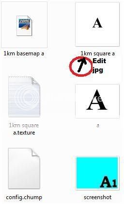
When you open up the BasemapSquareA Image in MS Paint or Irfanview it is white ... when you copy and paste the GE Image overtop of the white area and save it, it will no longer be white, and your image will be pasted there ... go into the basemap config file and rename the username line to be what you want it to be, save and commit.
It has been awhile since I stopped using basemaps ... and I just went back to measuring straight-a-ways, and connecting curves to them ... all tracklaying done by eye. Much more funner' !
It has been awhile since I stopped using basemaps ... and I just went back to measuring straight-a-ways, and connecting curves to them ... all tracklaying done by eye. Much more funner' !
Last edited:
Nice! Sounds like you're laying track like a real railroader! Hopefully I'll graduate to that level someday. ")
I am able to cut, paste and save the aerial image onto the blank basemap without any problem and it shows up in MS Paint just fine. It is only when I open Trainz Surveyor and place the edited basemap object that it appears blank, as if I never replaced the default blank image file with the aerial image.
Do I need to change the name of the config file? Perhaps that is the one step that I am missing? The default name is "config.chump". What do I need to rename it to?
cascaderailroad
New member
Now I remember ... it been like a year since I done did it.
The 1km square a is the one you open up, and paste into.
One of those dog eared pages, is the config file, where you type into the right side end of the username line: BlahBlahBlah
http://i525.photobucket.com/albums/cc339/cascaderailroad/AltoInterlocking1.jpg
http://i525.photobucket.com/albums/cc339/cascaderailroad/AltoInterlocking.jpg
Last edited:
AH HA!!! Just figured out the missing step (and it only took me FIVE hours...Haha!). I completely forgot that I needed edit the Basemap files in Content Creator Plus. As soon as I did that…low and behold…they appeared in Surveyor! Thanks so much again for all of your help, cascaderailroad. And now to start on my route! :clap:
cascaderailroad
New member
You beat my learning curve record ... it took me 4 months to find out that you could download assets from the DLS, and over 1 year to figure out that you could actually lay track in Trainz.:hehe:
roundhouse_rat
New member
I only had TRS2010 for just under a month,tell been a few late nights and going to bed on the crack dawn to figure out how to do this. but after cursing and swearing figure it quite easy after do your your first. let say took well over 3-5 hours to do my first to 3-5 minutes for my second map.
I be willing to talk anyone through the process on how to do it, but will need three things before you start Google Earth, The Gimp(Photoshop is fine), Trainz asset studio.
I be willing to talk anyone through the process on how to do it, but will need three things before you start Google Earth, The Gimp(Photoshop is fine), Trainz asset studio.
cascaderailroad
New member
Acually all you need besides GE or a Topo Map, is your PC built in Accesories: MS Paint and MS Snipping Tool
Signalman65
New member
You can use this same concept in Gmax to find the size of some thing you are modeling, and it doesn't have to be 1km. If you measure a ground area in ft or m, and screen capture the area, then change the image in a photo program to a resized mutlible .tga. You can then use it as a texture on a plane of the same size in Gmax, and measure the objects boundries, and parts with the tools in Gmax. I use this method all the time. Of course it doesn't help with the side views to well for height. You have to find something in the image of know height to base the other measurements on. Like my underpass, I knew it was 13' 10" from the road to the underside of the bridge.
Robert,
You seemed to have figured out how the insert your map. I have not.
This is what I have done so far.
1. Downloaded USGS maps for my shortline.
2. Downloaded the asset file "Basemap-2x2-km-example_512-v1" from Trainz.
3. Cropped my USGS map in a 2km x 2km map. This map is 1993 pixels wide and 2093 pixels high.
4. Replaced the "thumbnail.jpg" file with my map
5. Started Content Manager Plus and edited the thumbnail.jpg file. This file shows my map.
6. However, I found Trainz uses the "Sattile.im" file to lay on the baseboards.
How do I get CMP to replace the old map in Sattile.im file with my map?
Didrik
Robert,
You seemed to have figured out how the insert your map. I have not.
This is what I have done so far.
1. Downloaded USGS maps for my shortline.
2. Downloaded the asset file "Basemap-2x2-km-example_512-v1" from Trainz.
3. Cropped my USGS map in a 2km x 2km map. This map is 1993 pixels wide and 2093 pixels high.
4. Replaced the "thumbnail.jpg" file with my map
5. Started Content Manager Plus and edited the thumbnail.jpg file. This file shows my map.
6. However, I found Trainz uses the "Sattile.im" file to lay on the baseboards.
How do I get CMP to replace the old map in Sattile.im file with my map?
Didrik
You need to replace the .tga image on sattile.im with one of your own with the same name. Use an uncompressed .tga, which can be exported properly out of GIMP or some other photo-editing program.
John
I purchased TrainzDEM last week for under $30US. What a steal! I was able to download maps from USGS, create a relief map, super-impose Raster maps on top of the relief map; insert a shape file containing my shortline route (Everett & Monte Cristo Ry); and upload it into into Trainz 2009. This is fun! This is the only way to go if one is trying to create a prototype line.
The one problem I am having now is to find tunnels that match what existed along the line (timber face and interior; and no face and rock interior).
Didrik
The one problem I am having now is to find tunnels that match what existed along the line (timber face and interior; and no face and rock interior).
Didrik
cascaderailroad
New member
Contact me, as I took a long time to master the learning curve of Transdem ... You must be a wiz kid, a real natural at Transdem, I could use some pointers
I purchased TrainzDEM last week for under $30US. What a steal! I was able to download maps from USGS, create a relief map, super-impose Raster maps on top of the relief map; insert a shape file containing my shortline route (Everett & Monte Cristo Ry); and upload it into into Trainz 2009. This is fun! This is the only way to go if one is trying to create a prototype line.
The one problem I am having now is to find tunnels that match what existed along the line (timber face and interior; and no face and rock interior).
Didrik
Your journey has only begun! You'll be doing this for every route you build going forward, never mind the old hand sculpting of terrain now!
John
Similar threads
- Replies
- 9
- Views
- 518
- Replies
- 5
- Views
- 323
- Replies
- 4
- Views
- 305
- Replies
- 13
- Views
- 642