Surveyor 2.0 feedback thread

The game does not remember setting the water waves and water color, even after saving the game. When I save the game and then release it again, the water setting is reset. :confused: Neither the weather settings, the overall weather settings are reset to the basic settings.
 
Last edited:
I noticed many times the moment I hit the up or down button the view changes but ALSO the layer moves on step up or down.
>>
Thanks for the heads up. (The answer currently is to click anywhere in the world to remove focus from the asset palette).

The game does not remember setting the water waves and water color, even after saving the game.
>>
Fixed in the next update.
 

The game does not remember setting the water waves and water color, even after saving the game.
>>
Fixed in the next update.

Thank You,

I have a question if in Surveyor 2.0 will be able to create using a large brush the same as for the texture of the soil painting? So that I don't have to create a body of water for a long time when creating large areas? And the last wish is if it would be possible to cancel the sound below the water surface and darken the effect, because if I create a tunnel, for example, underwater, the effect sounds of the depths.?
 
Hi guys,

A couple of Surveyor 2.0 Feature requests. :)

Would it be possible to display a degree setting when placing tracks. eg: like to the ruler function has.

Can we have a way to import DEM data directly in to Surveyor 2.0 and or google/Bing maps (not with a third party tool) or are they protected.

Regards
 
Here's another feature request.

How about CTRL and SHIFT-clicking to allow for selecting and deselecting individual objects after a marquee has been used on a group of assets.

If this is available, then it's my coordination that's out of whack and I can't get the fingers to do what I want them to do.
 
Hello,

That is what I was looking for too, deselect a single item.

But, it would be good to see the number of selected assets, to make sure that one has what one wants to have and not more than that. If the assets overlap like multiple bushes, for instance, or large and small stuff.
Yes, it is possible to call up CM, but that is not a quick check.

Edit: sorry, unnecessary call. I found this number as "(+n)" behind the name of the asset selected latest...

Paul
 
Last edited:
Creating content, if the total of all the lods etc is greater than 500 polys the asset comes up as an error. Fine but it would be nice to use the preview to see how far above 500 polys the lowest lod is. When you have an interior, couplings, an exterior etc the meshes can add up.

Thanks John
 
When using Surveyor 2.0, how do we get and apply height to terrain?

I couldn't find this in the user manual.

Thanks.
 
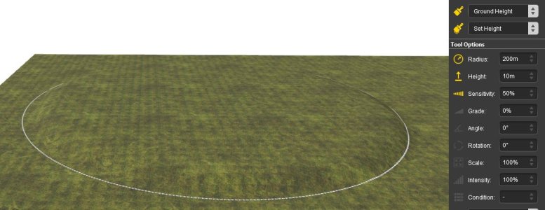
John, I found the height information in the Info palette on the right side of the screen beside where it says Focus. I had to pop it out and make the palette wider in order to read the height which is the last of the 3 sets of numbers. You can then select Ground Height, Set Height in the Tools palette and then enter whatever value for Height in the Tool Options palette. I hope I've been clear enough here.

Jack
 
Thank you, Jack.

I think it's clear enough for me to follow. If I run into a snag, I'll pop in again.
 
When using Surveyor 2.0, how do we get and apply height to terrain?
I couldn't find this in the user manual.
Thanks.

Hello,
That's covered here (Ground Height- Brush Modes) https://docs.trainzsimulator.com/docs/using-the-tools-palette

"Ground Height" > "Set Height"

Right click to get X Y Z

Though on a new board a brush "set height" of zero results in a deep deep hole.... I'm still trying to figure it out...

Odd... using "Grade" instead of "Set Height" seems to work. (Set Grade to zero and ground will return to zero)
 
Last edited:
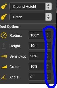
Also, if you select Ground Height and Grade, and then use a very large radius ~100m, sensitivity 20% and a grade of 10% it is possible to create nice gentle slopes. Using various combinations of radius, sensitivity and grade, a wide variety of slopes can be made.

For some reason, the up and down triangles are greyed out and not clickable. I have to enter a value directly by typing
grade.JPG
 
I must have a bug in my install. ANY height I set just makes a deep hole when I click mouse. I can also "get height" and "set height" and same thing. Deep hole. I'll try a EDBR?

EDIT: It's the REGION! "United States Region" will give me deep holes. Other regions work fine!
 
Last edited:
Hello,

It would be handy if one could cancel any adjustment with the Esc key, while making the adjustment (maybe unintentionally). Like this is already possible, for instance, while attaching a new piece of track.

Regards,
Paul
 
Last edited:
1611mac, I use Dave Snow's region on my route so I switched to the United States region and I find it is working fine for me. Something odd going on for sure.

Jack
 
Back
Top