Townsville Route Under Construction

Good gad, didn't know there was a version with a 3 inch gun (B-25-H) which had 4 50cal as well in the nose. I already have the lower pick of B-25 with a lone B-17 in front of the hanger. That aerial view doesn't make sense to me, the railway is on the south side of the Highway, not the north side, unless they are not calling Ingham Rd the Hwy?? True today, but I thought back then Ingham Rd was the Hwy?

Magazine-Hill-Townsville-circa-1940s.jpg
 
Got me beat mate. It's before my time. A lot was changed over the years. A decent toppo of the time would be good. I wonder if the Library has anything?
It seems as if every corner turned reveals a new one.
Those 50cals would have given the boys up front a bit of a shaking I reckon.
Regards
Frank
 
Anyone know of any decent 3ft 6in track, RAILS ONLY? I'm using Protrack but for some reason they didn't make a Rails Only version. The only one I can see is build 1.3 (rather than 4.2). The issue of a decent set of road/rail crossings is a problem too.
 
It certainly is. I'm guesing the bridge over the Ross River is just off the top of that by the looks of it. I was surprised to see a branch line going down Morey St and ending up in Seventh Ave.. I presume some sort of fuel depot for the tanks that used to be down there long before the bridge got built over Ross River, presumably after the big infill east of the eastern breakwater. Mega changes!
 
That branch line along Morey St went to the BP Installation down near the Victoria Park Hotel. On the bank of Goondi Ck which emptied into the Ross river. We pulled BP Bombs (tankers) from the Soth Yard and then pushed them down Morey St into BP and took the full ones back to the South Yard. BP was still there there in 1985 but I think it's gone now. We were supposed to walk in front of the loading across the roadways and stop any traffic. Not Frankie. I was of the opinion that if they couldn't see a rake of bowsers coming down the track and the engine blowing his horn thenthey had no hope of seeing me. I and my shunter rode the leading buffers. As we approached a roadway I'd signal to the driver to blow the horn.
I don't know when BP installation was built but the tanks didn't look too old when I was there mate.
Frank
 
Anyone know of any decent 3ft 6in track, RAILS ONLY? I'm using Protrack but for some reason they didn't make a Rails Only version. The only one I can see is build 1.3 (rather than 4.2). The issue of a decent set of road/rail crossings is a problem too.


Have you tried Trainzone, as among other things they have some really nice free NZ 3'6" gauge track for download including rails only tracks. I don't know how well they would work in TRS19 though, as I've only used them in TRS04 and 2010. Still, it's worth a shot.
 
Is this anygood to you Ali? Road with double yellow lines but in Trz2012.
'Kuid2:45676:137032:2'. Is 12 compatible with 19?
I'm also strating to run out of options trying to find any more Townsville 1939 - 1945 info. I've been trying to find old Townsville road maps but not having much joy. It doesn't seem to make sense that the northern highway was on the other side of the train line. But stranger things have happened. I found there were a fair few runways around the Townsville area during the war. I might see what the John Oxley Library can come up with. They will supply a librarian for I think 3 personal searches a year. I've used them a couple of times. Frank
 
Build number isn't an issue, even Build 1.3 items work in TRS19, but may look horrible, or not. I've download that road, but I suspect there may be attachment problems, but I'll give it a shot. :)
 
Re the post on 28th December. I think they may have made a typo or something re the highway mate. As far as i can find out, Ingham Rd was and is the highway north.
Maybe part of Garbutt is right at the top of the photo and the Stock Route airfield is the main emphasis in the photo.
Here is something else that maybe help??? to clear it up because it shows Ingham Rd in a better view. But like I stated, Ingham Rd was the highway......Not Woolcock Street.
Is your head spinning yet? ;-)
Explosive Stores 102, 102A, 106 and 120, Garbutt Airfield, Townsville, Queensland, in Australia during WW2 (ozatwar.com)

Regards
Frank
 
Surprising it isn't spinning yet! That map also makes it easier to work out the airfield cause I could see the extra two landing stripes got changed, in fact I think one was deleted? In fact I think Woolcock St didn't go right through until after the 1960s? I'd have to dig through all my info to confirm ^_^
 
She'll be jake mate. They reckon valium helps to settle things down. I've got some pretty good pain relief that gets you trippy. Joke joke.
I tend to agree with you. Ingham Rd had/has to be the main highway out of town to the north. I didn't know there were so many strips around the Townsville area though.
I'll see if I can find a detailed Rail map to the Isa that shows how close the railways were to the airstrips.
 
As I may have mentioned, railway road crossings is a problem given no suitable ones for Queensland, although there are some specific but now old ones of Build 3.7. The problem with these QR Level X-ing ones is all roads attach under the surface, burying the actual road spline joint. I've made hopefully polite, request to have this fixed. I did try it myself, but it added the AUS Road Rural to the underside of the existing old road surface!. I need to upload some more recent snapshots too.
 
Slowly getting more work done on this very large route. I have seen that there is an error between google earth and TransDem, the UTM tiles needed to be move 120 metres east and 20 metres north, as clearly there is a mismatch. Unfortunately I'd done the Townsville area before I confirmed my suspicions. Meanwhile here is the Bluewater River Crossing.

Bluewater-River%2C-North-Townsville-WIP..jpg


Here is the map layout, which includes a large ocean area off Townsville with the southern tip of Magnetic Island. The later is to allow for future WW2 sessions, with battle fleets and air-raids :)

Townsville-Route-WIP.%2C-circa-1940s%2C-Southern-tip-Magnetica-Island-top-centre.jpg
 
Frank, from what I read the Queensland Nickle site and mine were only from the 1970s, I assume therefore the line SSW which crosses the main line was only built then? Which means I can delete that leg and save some work. Also was Kulburn Station on the main line or did it include a siding? I won't be buying any more plans as that $56 Morrison siding was a one sheet plan with the single main line and one small passing loop, and nothing else! Turns out its' just passed where I plan to stop at Rollingstone, which during WW2 provided extra water for Townsville, carted by tankers on the railway. The southern leg (to Mt Isa) stops just passed Woodstock so I can include the first airfield there.

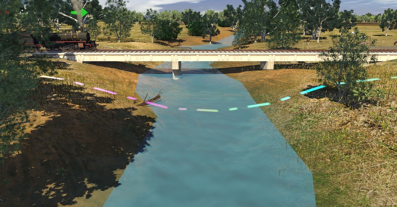
From about Campoven Creek there seems to be errors between the grades and google earth, as the land rises up and down where-as street view clearly shows it's almost dead flat. I'm having to fudge the grades a number of times! Saltwater Creek seems to have about the only steel girder bridge I've found so far.
 
I have a copy of a book called 'Thirty-three miles to Rollingstone, given to me by Peter Renton, with some other articles. He is the son of Cyril Renton who designed the DD17 class 4-6-4T engines for QR. Pity we don't have a decent example for Trainz of this loco, although there is an old and very brightly painted version. Not sure if it's the right gauge as many QR items were made to the wrong gauge (and sometimes both gauges). Rollingstone is the end of the line for this route, and was quite busy during WW2. There are a dozen defensive positions around it, which were never fully completed, probably as the Battle of the Coral Sea more or less stopped the Japanese plans in this area. So, I quick picture, before I get back to work.

Rollingstone%2C-Townsville%2C-1-of-12-incomplete-defensive-positions.jpg
 
The DD17 is being sorted by myself, however my 3DS max license has expired and i will be sorting a new license soon.
 
Back
Top