How accurate can you make TransDEM routes?

nikkigirl1

Building "The Cutoff"
So I am in the process of building a sort of "mega route" that includes the roads of many long-gone companies, namely the EL, Lehigh and New England, L&HR, NYS&W, and later NJT, Conrail. The main feature of this route will be the DL&W/EL/Conrail's Lackawanna Cutoff, and this is where the problems are arising with TransDEM. The Cutoff in itself is a big landmark, with multiple large cuts and fills that are very much still prominent today, and no matter how much I play with TransDEM, I cannot find how to get these terrain details to show upon importing of the route. I have one save where I have went through and hand-leveled the entire cutoff to prototypical height and gradients, along with making the fills and cuts, but the problem with this is that these are at times highly contrasting with the terrain that TD provided, namely with the Pequest Fill, which is at times more of a cut than a fill when using TD data.

mqdefault.jpg


46659427.jpg

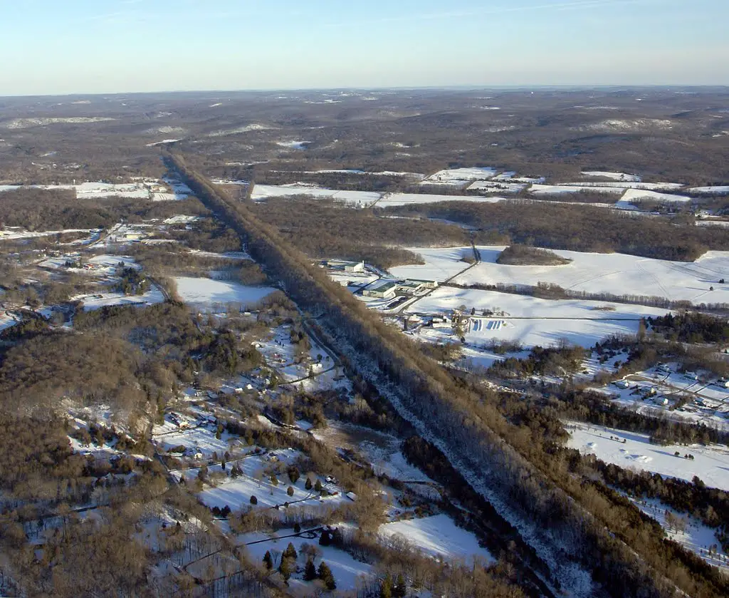
This is Pequest Fill, early 1900s and now, and as you can see it stands out prominently to the naked eye, but not to TransDEM. I have used two different DEM sources, USGS and Japanese satellite DEM imagery, with the latter being a hair more accurate after playing around with DEM grid width, but it still barely stands out in a DEM, although you can eyeball the Cutoff perfectly-- from satellite height--while in TransDEM pre-export.

My question for all of you that at least know something about TransDEM, what settings can I use to get stark terrain differences to stand out by using TransDEM, or is hand-sculpting the only option here?
 
Don't know the scale of that long feature in the image but there is a limit on how small something can be created in Trainz using the terrain. Not sure how closely TransDEM conforms to those limitations. Also, if the DEM data is not dense enough, thin structures might not even be seen in the data. As well, vertical or overhanging cliffs are not supported directly in Trainz. Using objects made to show those is what is generally done.
 
What level of resolution is the original DEM?

The 1/9 arc-second is the finest you can download and will yield the best results, however, at a cost of much, much larger DEMs to begin with. When exporting the route from TransDEM you can set the resolution to the highest level that Trainz can handle which is 5 meters. Given that this will make the file really much larger than necessary all over, you can set the option to use the 5 meter grid along the tracks and leave the rest at 10 meters. To use this option, you need to place a track spline for the program to use within Trans DEM by drawing poly line along the route.

Now, this goes without saying a lot here, that Trainz is a world of compromise. You can be as accurate as you can be, but still have to compromise and do things that aren't quite 100% to the prototype whether it's the track layout, placement of signals, crossings, kinds of bridges, and even buildings. It's also easier to model a modern prototype than one that's been gone for decades due to extant buildings and site accuracy. When dealing with historic routes, we can only compromise and make buildings and assets as close as we can based on drawings and photographs since many of the original structures are long gone.

When I worked on a prototype project, I compromised the grade as well. I found the highest and lowest points and let Trainz smooth out the grade in between. I initially attempted to follow the grade closer, but found due to our lower resolution grid the differences were much higher than the prototype and more like a seesaw than in real life. Like you, I found I could not get the grade 100% as much as I tried. Then I remembered, we forget that we're stuck with that 5 or 10 meter grid while the real world has an infinite one.
 
You know I forgot about the 5M grid option. For some reason I thought it was going to cause issues and didn't bother and kept 10M. The funny thing is I had 5M data :)

I'm already too far along and yeah there is compromises for sure. River banks that seem to be off a bit between the UTM and the DEM. Honestly though I'm ok with the compromises as long as it looks realist enough. TransDem is a huge time saver in that regard.

But back to the OP, I find plenty of man made structures don't make it into a DEM. Now I'm not sure how that accounts for it or not. Curious if it's showing up on the DEM or just not showing up in your route.

Thanks

Sean
 
My-North-NJ-DEM.jpg
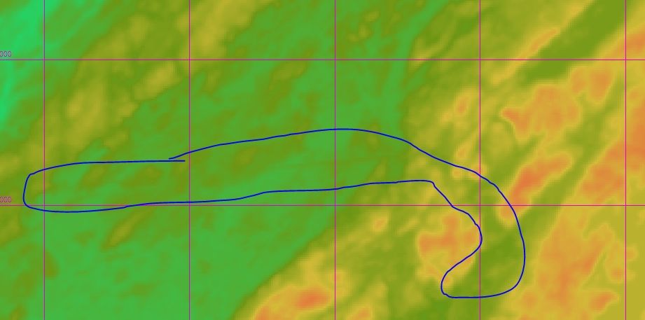
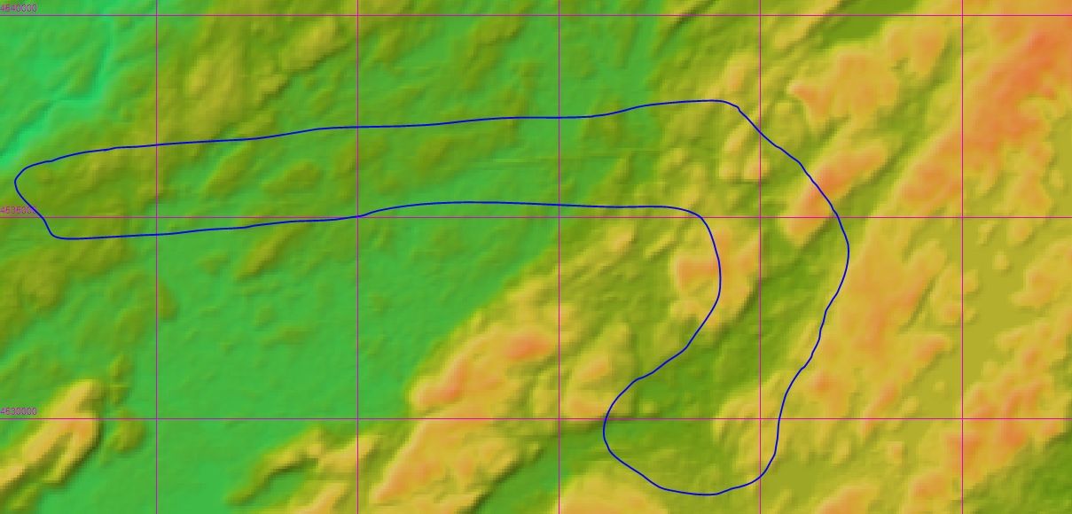
Here would be the cutoff in the DEM, as you can see the long green line, the raised Pequest Fill, is a prominent standout , and the cuts can be seen too. I don't know if it is 5m or 10m data that I downloaded, but where can I get 5m data, USGS? In trainz, when I export as 5m, the cutoff is just part of the rolling hills of Northern NJ, so in other words, it doesn't exist. As for buildings and whatnot, most are still there so placing them is not a chore. My question is, how do I set the arc-second stuff, and I know about the 5m export size, but about when I just create the new DEM, it asks about the grid width, should I leave it at 50 there or bring it to 5 there as well?
 
Here would be the cutoff in the DEM, as you can see the long green line, the raised Pequest Fill, is a prominent standout , and the cuts can be seen too. I don't know if it is 5m or 10m data that I downloaded, but where can I get 5m data, USGS? In trainz, when I export as 5m, the cutoff is just part of the rolling hills of Northern NJ, so in other words, it doesn't exist. As for buildings and whatnot, most are still there so placing them is not a chore. My question is, how do I set the arc-second stuff, and I know about the 5m export size, but about when I just create the new DEM, it asks about the grid width, should I leave it at 50 there or bring it to 5 there as well?

Pic-removed.


Download the 1/9 resolution DEM instead of the 1/3 resolution if there is one and should be. However, the issue too you might be running into is the original data maybe older to begin with. The older technology lost a lot details. While not at the same scale as this, I ran into a similar situation in the area where I live. The railroad grade runs against a 383 ft hill on one side and factories on another. When the satellite data was created, the 15 ft grade blended right into the factories and the hill, creating a blob of nothing. The road below that runs along the river was also up at the railroad height as well. This made working on this area very difficult to untangle and I gave up on it.

Your best bet is to check the NSGS server for the 1/9 resolution for that area.

You are lucky with the buildings. Position is relatively easy anyway.
 
Yes, as John said, use 1/9 arc sec where available. There are even a few spots with 1 m LIDAR DEMs now. Downloadable from the National Map portal.

(Hi-res DEMs make no sense in Plate Carrée pseudo projection and arc seconds, due to the necessary re-projection and the loss of detail accompanying it, hence they are metric and aligned with the UTM grid, the native grid in TransDEM)

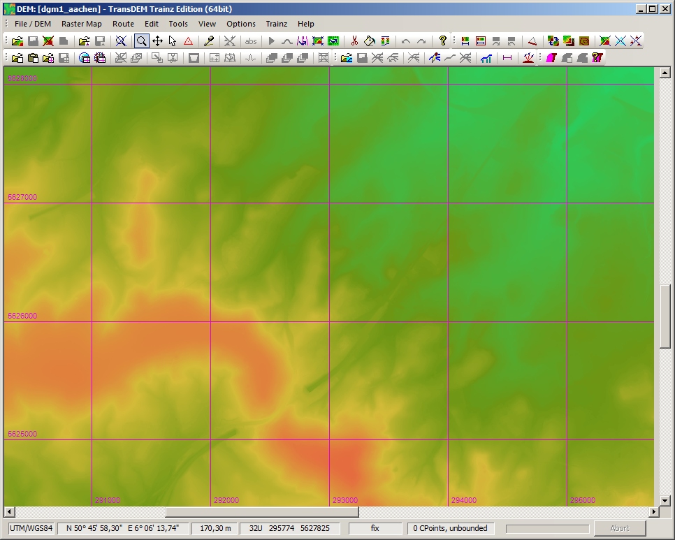
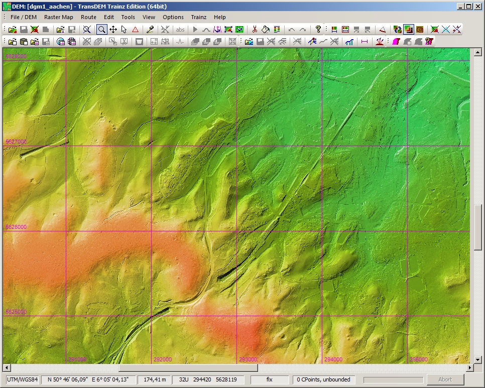
When viewing DEMs in TransDEM I would always switch on Shading. This will emphasize the details. See example below (1 meter DEM from my home town).

dgm1-ac.jpg


dgm1-ac-shaded.jpg
 
Hello:

I guess I'm getting confused at the term arc second vs meters. I understand a 5m or 10m DEM which is I believe what I used 5m USGS covered the United States and parts of my area in Canada. Then I had to switch to 10m or 15m (can't remember) in a part USGS didn't cover. So I just used that portal and found 1/9 not available for my area however 1/3 is. Does that have an equivalent m value or approximate?

Also because I've started and reset so many times I finally settled on what I had and started developing. I had to make some compromises where the river bank UTM actually was a bit off to where the DEM was saying it was. The UTM I used was I believe a combination of Open Street Map and Bing Ortho highest level near tracks.

One last question on this. I'm developing mainly track only. I think I asked this before but I'm not sure. So I'm carefully plotting the locations of the main in TRS19 now and actually adding in my yards as well. If another DEM is available and I want to try again, is there any way I can take that route data save it and bring it in to TransDem? I know you can import splines, but I'm not sure if that is compatible with what TRS19 produces or can export.

Thanks

Sean
 
I guess I'm getting confused at the term arc second vs meters.

The Trainz baseboard grid is either 5m or 10m. 5m will get the better terrain detail.

TransDEM maps geo data to Trainz World Coordinates. Trainz doesn't really know about geo data and its features. It just expects something that fits to its planar metric world model.

Practical geo data is always a projection, as the Earth, unfortunately, is not flat (despite some people still believing it is). TransDEM decided to use UTM as its native projection, a zonal Transverse Mercator projection. All geo data that comes in UTM and is based on WGS84, NAD83 or similar geodetic datums, can be transferred to Trainz directly, without reprojection.

Low to mid resolution DEMs often come encoded in the so-called Plate Carrée projection, which isn't really a projection but a very simple mapping of lat/long degrees/minutes/seconds to a plane. The x axis usually stands for longitude, the y axis for latitude. Now, the way longitude and latitude are defined, the real distances expressed in lat/long vary with latitude. Therefore there is no precise equivalent between arc seconds and metres. While the parallels (latitude) retain their distance, the meridians get closer the further north or south you go from the equator, until they all touch themselves at the poles.

So, in y direction (latitude) distances remain constant, but in x direction (longitude) they shrink with latitude. The typical 1 arc sec DEM will be about 30m x 30m at the equator, but 20 x 30 m at 50° latitude. TransDEM always creates a uniform grid, when it converts to (UTM) metres, taking the smaller value and rounding it for a preset.

A rule of thumb for the so-called moderate latitudes is 2 x 3:
  • 3 arc sec roughly equals 60 x 90 m, making it 60 m in TransDEM
  • 1 arc sec => 20 x 30m => 20 m
  • 0.75 arc sec (standard resolution for Canada) => 15 x 22 m
  • 1/3 arc sec => 7 x 10m
  • 1/9 arc sec => 3 x 4m => 5 m in TransDEM
Keep in mind that the resulting resolution in TransDEM is only the nominal resolution.

There are also other factors to consider, as the some DEM sources themselves have a higher nominal resolution than the true resolution. Examples are SRTM 1 arc sec which is really just a slightly enhanced 3 arc sec. And I have also come across some USGS 1/9 arc sec, which was no better that 1/3 arc sec (Virginia & Truckee in Nevada).
 
So I'm carefully plotting the locations of the main in TRS19 now and actually adding in my yards as well. If another DEM is available and I want to try again, is there any way I can take that route data save it and bring it in to TransDem?
Not really. All Trainz coordinates are 3-dimensional. If you swap the terrain (theoretically), the objects you have placed before may hover above the new ground or will be buried below.
 
Yes, as John said, use 1/9 arc sec where available. There are even a few spots with 1 m LIDAR DEMs now. Downloadable from the National Map portal.

(Hi-res DEMs make no sense in Plate Carrée pseudo projection and arc seconds, due to the necessary re-projection and the loss of detail accompanying it, hence they are metric and aligned with the UTM grid, the native grid in TransDEM)

When viewing DEMs in TransDEM I would always switch on Shading. This will emphasize the details. See example below (1 meter DEM from my home town).
Pic removed

So would this shading show up in the exported trainz route, or is the shading just for viewing purposes in TransDEM? And, wouldn't you know it, the 1/9 arc-second data covers nearly everywhere--- except the Cutoff. So when using 1/3 arc-second data, is there really any course of action to make a, I don't know, 30 meter by 30 meter cuts and fills show up in an exported route without hand-carving it? If that is the case I have a route that I already did this, but in setting the grade I made some areas pretty un-prototypical, so I am looking for the best possible solution naturally.
 
Hmmm I might just look into giving it a shot and if I lost it I'll just start over again. Sounds like this new DEM might be more interesting. Not to mention the 5M instead of 10M to get even more detailed.

Thanks

Sean
 
By the sounds of it I likely have the best resolution of DEM. I believe it's 1/3 shows up as USGS 13 because they can't use the slash. Which comes up to about 5m.

I might try setting it to 5M and see (but I believe this can get quite large).

Perhaps trying it over a smaller area and see if I like it better might help.

Thanks

Sean
 
So would this shading show up in the exported trainz route, or is the shading just for viewing purposes in TransDEM?
No, this is just to enhance the visual impression. You will get a better idea whether cuttings and embankments/high fills are actually present in the DEM.

So when using 1/3 arc-second data, is there really any course of action to make a, I don't know, 30 meter by 30 meter cuts and fills show up in an exported route without hand-carving it?
1/3 arc sec will translate to a 10m grid. This is not too bad, keeping in mind that 10m is the original Trainz baseboard raster, before they added the higher resolution 5m.

If part of your route is available as 1/9 arc sec I would start in TransDEM with that raster, usually 5m, and fill the gaps with 1/3 arc sec. Use the "Fill-up" function for this. You might notice a seam where the two resolutions meet, but that can be easily smoothed in Surveyor.
 
So it sounds like 5M probably wouldn't do me any good if the best I have in my area is 1/3 then. I like the idea of compromise :)

Thanks

Sean
 
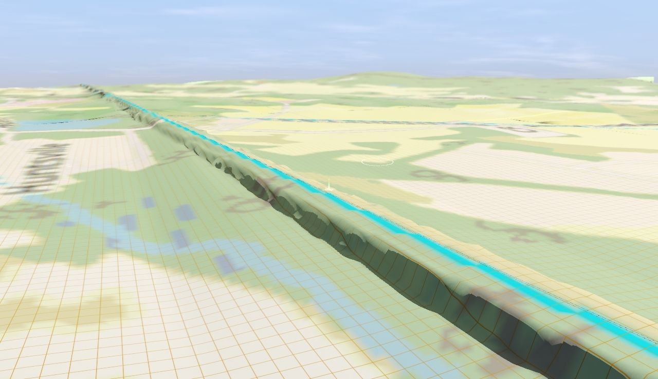
Pequest-Fill--Lackawanna-Cutoff.jpg
This would be the result of doctoring a 1/3 arc second DEM. The Pequest Fill, although not accurate in terms of width yet, is up to the precise height level that it needs to be. Before, it was raised as high as the land below it. I guess 1/3 arc-second data could never recreate this straight out of TransDEM?
 
I guess 1/3 arc-second data could never recreate this straight out of TransDEM?
Theoretically, it could. But often, the nominal resolution is higher than the physical resolution. You can check in TransDEM, with shading on. How pronounced does the fill appear there?
 
DEM won't do track embankments or rail beds it only builds ground textures and gives you a real landscape. It's a hard program to learn at first but its worth the money, I use it I recommend it! Disregard the last part.
 
Last edited:
How pronounced does the fill appear there?
This is with shading on. A little more pronounced.
My-North-NJ-Cutoff-Fill-DEM.jpg

I have used a different DEM source along with messing with the grid width when creating a new DEM, I set it around 30m grid width I think, I don't know if it did anything anyway but if anything it just added a small hill where the Pequest Fill is. Should I lower that value down to 5m as well?
 
Back
Top