No this isn't a video!
In 1967 my dad took me for a trip I'll never forget. When I was young, my dad would bring me to his workplace at least once during my school vacations. This daylong excursion would involve taking the commuter rail from Bradford (Haverhill) to North Station in Boston where we would take the trolley to his office on Boyleston Street in the Prudential Tower. If this wasn't enough, the view from the 23rd floor was truly awesome. Using a telescope, I could watch all the activity all around me like watching an active model railroad, or today in Cities: Skylines.
This day was different all around. We boarded the usual B&M Budd RDC 6-car train, which made it's usual stops along the way. We passed through Lawrence, after stopping at the old station there, and then passed by the site of the old engine house and turntable near Union Street.
https://www.google.com/maps/@42.6842917,-71.1523411,256m/data=!3m1!1e3
Today there's a Valley Sports Arena in that location, but back then there was a number of diesels steaming away in the cold morning since this was February vacation. I don't remember the old models there since I was quite small, but I do remember seeing the fronts of them and steam coming out all over.
We crossed the street and took the Green Line trolley from the lower station - more about this later. This was a PCC trolley as usual, but instead of being the common single-ended car, this was one of the rare double-ended cars the MTA had purchased from Dallas. I didn't know it at the time, of course being all of 6 years old, but anyway these cars were converted to single-end and assigned to the Mattapan-Milton line so that was even more rare even though I didn't realize it.
I went through the day, and then we went home. We didn't take the trolley back to North Station, but instead took the trolley from Prudential station to Park Street where we walked the connector tunnel between Park Street and Washington Street, aka Downtown Crossing today, where we got on an Orange Line EL car heading outbound.
Car was crowded, but we managed to get a seat up in the front near the window where I could watch the motorman drive and look out the front window. After Chinatown, the old BERy Mainline headed up on to an EL structure similar to Chicago. I remember seeing the stations and signals as we rattled down the rickety elevated line. When we reached the terminus at Forest Hills, we switched sides and headed. Instead of getting off the train at North Station, we continued on the EL as it passed through Charlestown and into Somerville where we disembarked at Sullivan Square station. From what I remember, my dad said we didn't have a chance to ride all the way to Everett Square, which was the end of the line on the north side, and we had to head back to North Station to catch the train home.
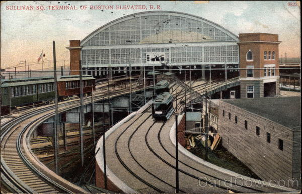
The BERy had an interesting setup around North and South Stations. Up until the early 1930s there was an EL called the Atlantic Avenue Elevated, which ran more or less along Atlantic Avenue and connected North and South Stations together. This line succumbed to low ridership during the Great Depression and was scrapped. The setup at North Station was quite unique as I said. The trolley line split there with one part terminating under the EL at the corner of Canal and Causeway streets while the other part continued up on its EL parallel to the BERy mainline, stopping at North Station above, and then going on to Lechmere Square where it terminated in a loop. Up on the EL next to the trolley station, was a stub of the old Atlantic Avenue Subway which was quite visible until the whole structure was removed in the late 2000s when the new North Station was built. In addition to the trolley and Atlantic Avenue line having a platform, the BERy mainline also had a stop there as well.
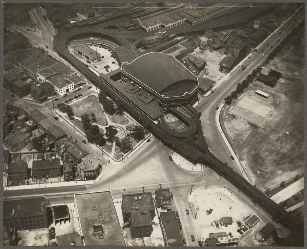
In 1967 there was little thought of what would happen to the EL. In 7 short years, the north side from Everett Square to North Station was torn down and the Orange Line subway was moved from the EL to the B&M Western Division Main Line. The plan was to terminate all passenger Trains a Reading on the northside and run the third-rail electric up to Reading. The plan fell through and the line today only goes as far as Oak Grove. The damage, however, is done. The beautiful glass shed and loops are gone at Sullivan Square. Today the station name is the same, but instead is a cold concrete affair tucked under interstate 93 next to the commuter rail line which screams by at 65 mph.
The Southside from Chinatown to Forest Hills remained in place until 1987 when that portion was moved to the Southwest Corridor commuter rail line. When the Jamaica Plain trolley service was abandoned in the early 2000s, the beautiful Forest Hills station was torn down. There was a lot of protests over abandoning this line in the first place and the move to preserve this Art Nouveau station failed as well as that all fell on deaf ears.
Now for the pics.
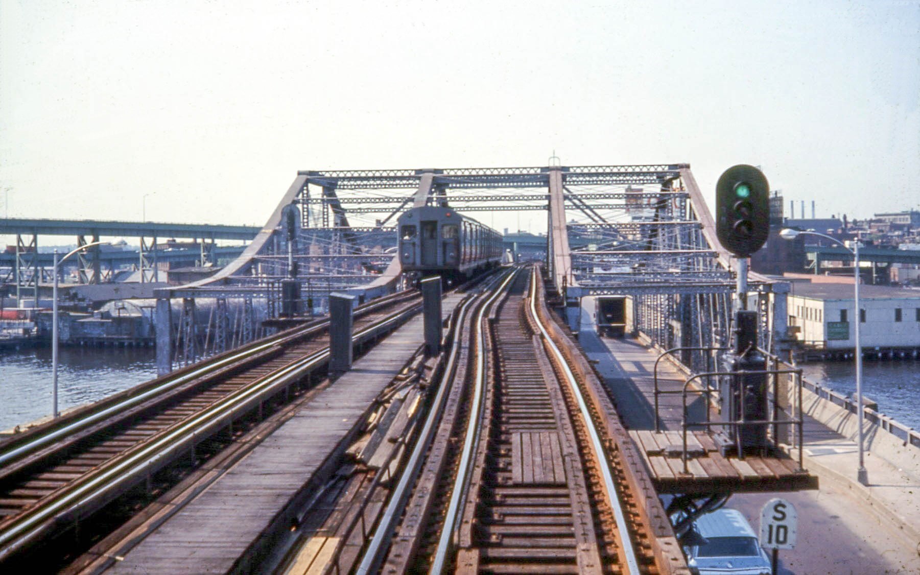
Taken in the late 1960s: A crossing the Charles River on the Charlestown bridge. This unique drawbridge has a road underneath (Rutherford Avenue) and sadly is slated for removal!
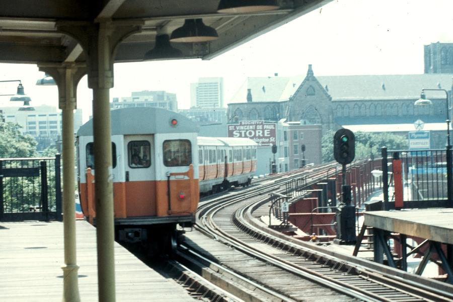
Pulling into a station. Note the old GRS colored light signals!
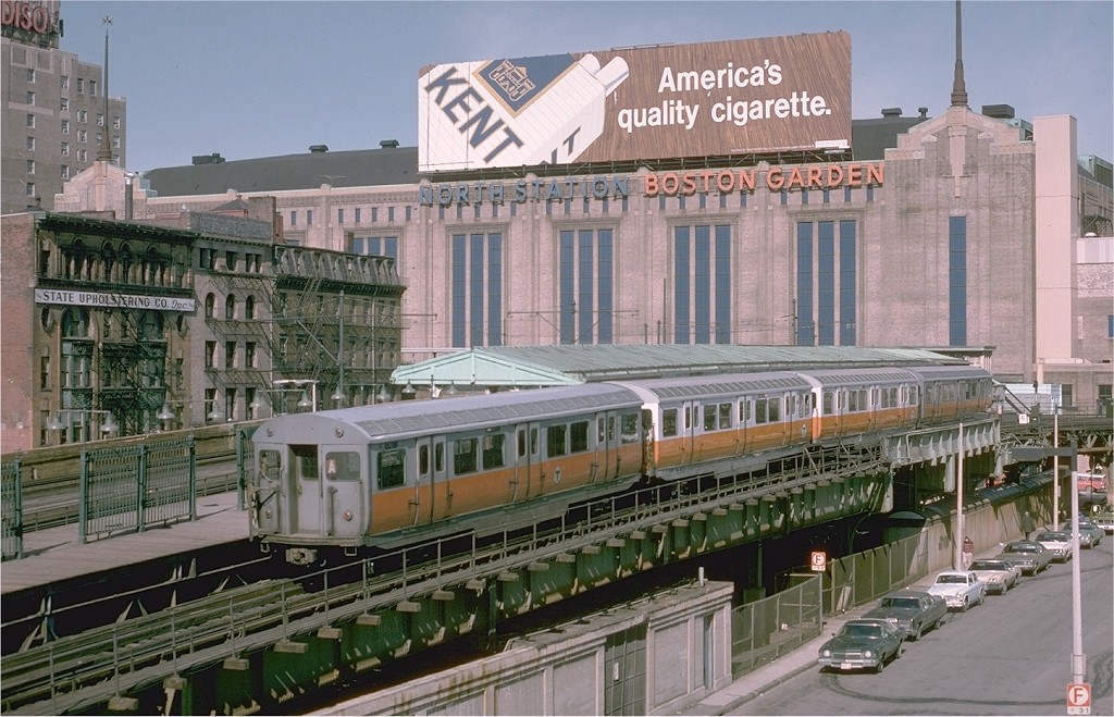
Pulling into North Station. The Green Line trolleys continued to the left over Causeway Street stopping in front if going to Lechmere, or terminating under the EL where you can see the shelters on the right.
In 1967 my dad took me for a trip I'll never forget. When I was young, my dad would bring me to his workplace at least once during my school vacations. This daylong excursion would involve taking the commuter rail from Bradford (Haverhill) to North Station in Boston where we would take the trolley to his office on Boyleston Street in the Prudential Tower. If this wasn't enough, the view from the 23rd floor was truly awesome. Using a telescope, I could watch all the activity all around me like watching an active model railroad, or today in Cities: Skylines.
This day was different all around. We boarded the usual B&M Budd RDC 6-car train, which made it's usual stops along the way. We passed through Lawrence, after stopping at the old station there, and then passed by the site of the old engine house and turntable near Union Street.
https://www.google.com/maps/@42.6842917,-71.1523411,256m/data=!3m1!1e3
Today there's a Valley Sports Arena in that location, but back then there was a number of diesels steaming away in the cold morning since this was February vacation. I don't remember the old models there since I was quite small, but I do remember seeing the fronts of them and steam coming out all over.
We crossed the street and took the Green Line trolley from the lower station - more about this later. This was a PCC trolley as usual, but instead of being the common single-ended car, this was one of the rare double-ended cars the MTA had purchased from Dallas. I didn't know it at the time, of course being all of 6 years old, but anyway these cars were converted to single-end and assigned to the Mattapan-Milton line so that was even more rare even though I didn't realize it.
I went through the day, and then we went home. We didn't take the trolley back to North Station, but instead took the trolley from Prudential station to Park Street where we walked the connector tunnel between Park Street and Washington Street, aka Downtown Crossing today, where we got on an Orange Line EL car heading outbound.
Car was crowded, but we managed to get a seat up in the front near the window where I could watch the motorman drive and look out the front window. After Chinatown, the old BERy Mainline headed up on to an EL structure similar to Chicago. I remember seeing the stations and signals as we rattled down the rickety elevated line. When we reached the terminus at Forest Hills, we switched sides and headed. Instead of getting off the train at North Station, we continued on the EL as it passed through Charlestown and into Somerville where we disembarked at Sullivan Square station. From what I remember, my dad said we didn't have a chance to ride all the way to Everett Square, which was the end of the line on the north side, and we had to head back to North Station to catch the train home.
The BERy had an interesting setup around North and South Stations. Up until the early 1930s there was an EL called the Atlantic Avenue Elevated, which ran more or less along Atlantic Avenue and connected North and South Stations together. This line succumbed to low ridership during the Great Depression and was scrapped. The setup at North Station was quite unique as I said. The trolley line split there with one part terminating under the EL at the corner of Canal and Causeway streets while the other part continued up on its EL parallel to the BERy mainline, stopping at North Station above, and then going on to Lechmere Square where it terminated in a loop. Up on the EL next to the trolley station, was a stub of the old Atlantic Avenue Subway which was quite visible until the whole structure was removed in the late 2000s when the new North Station was built. In addition to the trolley and Atlantic Avenue line having a platform, the BERy mainline also had a stop there as well.
In 1967 there was little thought of what would happen to the EL. In 7 short years, the north side from Everett Square to North Station was torn down and the Orange Line subway was moved from the EL to the B&M Western Division Main Line. The plan was to terminate all passenger Trains a Reading on the northside and run the third-rail electric up to Reading. The plan fell through and the line today only goes as far as Oak Grove. The damage, however, is done. The beautiful glass shed and loops are gone at Sullivan Square. Today the station name is the same, but instead is a cold concrete affair tucked under interstate 93 next to the commuter rail line which screams by at 65 mph.
The Southside from Chinatown to Forest Hills remained in place until 1987 when that portion was moved to the Southwest Corridor commuter rail line. When the Jamaica Plain trolley service was abandoned in the early 2000s, the beautiful Forest Hills station was torn down. There was a lot of protests over abandoning this line in the first place and the move to preserve this Art Nouveau station failed as well as that all fell on deaf ears.
Now for the pics.
Taken in the late 1960s: A crossing the Charles River on the Charlestown bridge. This unique drawbridge has a road underneath (Rutherford Avenue) and sadly is slated for removal!
Pulling into a station. Note the old GRS colored light signals!
Pulling into North Station. The Green Line trolleys continued to the left over Causeway Street stopping in front if going to Lechmere, or terminating under the EL where you can see the shelters on the right.
Last edited: