The L&NE, DL&W, and NYSW are coming alive in Trainz

nikkigirl1

Building "The Cutoff"
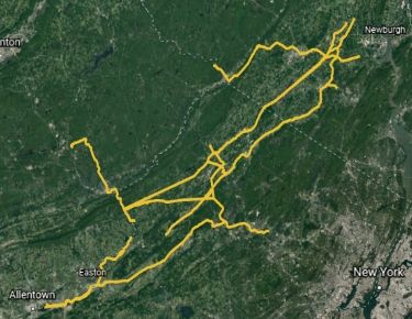
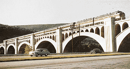
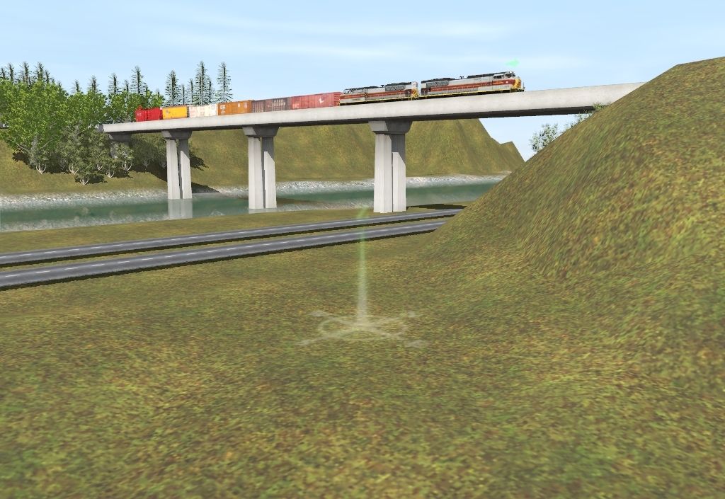
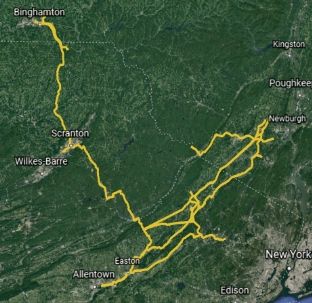
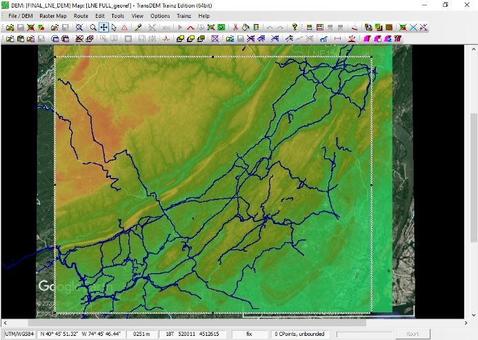
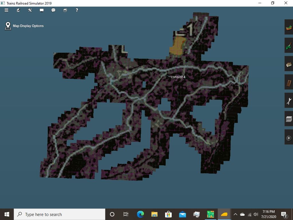
After freehanding the local rail-trail that runs through my family’s dairy farm in Trainz 2010, I have decided to take on the big venture of modeling the whole of the North New Jersey rail routes that have since been turned into rail-trails or left to be overtaken by vegetation and housing complexes. The DEM route will span from north of Campbell Hall, NY, where the Susquehanna has a wye and where the L&NE used to terminate. The route will then spider into a few general directions, most leading to portals to show where I really could not find any more track bed that still existed, but one line will run itself to Port Jervis where it goes to NJT, and another will progress down the old L&NE, through Sussex, Newton, Blairstown, all the way to where she crosses the Delaware and over some. I am debating on going right to the Pen Argyl Yard, but I have to wait for some of my outside sources to get to me since most of the L&NE track bed no longer exists on Google Earth. Also on the route will be the crossovers of the DL&W in Augusta as well as the NYSW-DL&W crossover at Warbasse Junction in Andover. The route will feature the famous DL&W Pequest Fill, Delaware Viaduct, and basically the whole Lackawanna Cutoff, which NJT plans on restoring service to in the coming years. The farthest the route spans is about down to Allentown, PA with the L&NE and to Mt. Pocono with the DL&W so far. DEM is still in extreme early stages, I can only add so far what trackbed I know exists on Google Earth, and most lines I connected on there are correct, with the exception of a few that I could no longer identify trackbed through buildings or overgrown vegetation. The route depending on the area will be set anywhere from the late 1950s right up to the modern day depending on what industries I want to include, and what content I can include in the route. Anyone that is familiar with the region and can help me in laying the trackbed in DEM is welcome to give me some pointers as this is just beginning, and even though it is my first route, this is hopefully going to be something I will be very proud of in TS2019.

6ef9d28b-7c83-4022-9657-e7feee172e26
 
Last edited:
My-North-NJ-Route.jpg


As seen right in the middle of the photo, right where the majority of track is, is the formal "starting location" of the route. This is my most familiar area as the trackbed still mostly exists and is where the three railroads intersect each other. The small line that protrudes off to the northwest in Sussex is the DL&W's "Branchville Line" which was used to take milk from the abundance of dairies around in the 1940s and 50s to the creamery, as well as to supply boxcars of agricultural supplies and hoppers to the now defunct Roy Company, which was one of the last industries to be served until the removal of tracks during the Erie Lackawanna days. This line has access to a turntable as well. When moving south, the line will cross over the L&NE, whose main duty was to move coal and ores alike. This line is accurately portrayed so far until a little past Blairstown, when vegetation and buildings ruined my chance to trace the line, so I connected it to the DL&W's Delaware River Viaduct for the time being.
 
This leads to the Lackawanna Cutoff, one of the smoothest, fastest rail routes in the state at the time
CutoffViaduct.gif


The cutoff is an engineering marvel in itself with its use of concrete bridges, fills, and elevated trackage along it. This was easier to trace out and map in TransDEM, as the line is rather clear of foliage due to NJT wanting to restore service to the line. For just a glimpse into a very, very crude version of what I want this to look like, here it is:
My-Trainz-Screenshot-Image.jpg


Again, crude but before the DEM route is done all I can use to represent significant areas are cheap freehand areas. This line is probably best for the fast long-haulers, since this line goes from the Roseville Tunnel area up to Mt. Pocono. I am debating on whether I want to return the line to its 30s-70s appearance- no trees, clean fill, or modern day with rails, which is with trees hugging where the lines used to be. All in all, I will need outside info from you fellow Trainzers who have knowledge on this area as I start to build the route itself on TransDEM, so feel free to shoot me a pm on signal types of the era, where certain trackage was, or if you feel like helping me make the DEM map itself.
 
That is an awesome project to undertake Nikkigirl1! Best of luck and you can get lots of help here on the forums. You can also start a thread in the screenshots forum, or post updates under the "Show us your routes" thread. Looking forward to following your progress!
 
My-North-NJ-Route-Finalized.jpg


Here is the 90% finalized trackage. The route will now extend to Steamtown on the DL&W and terminate outside of Scranton, but will also proceed north up to Binghamton Yard where the route will ultimately terminate. The L&NE has a much more definite route into Newton Yard, and the DL&W's Sussex Branch is 100% accurately depicted down through Great Meadows and down toward Easton. This route will feature many small yards and crossings as well as industries like creameries and passenger stations. This is a very suitable route for passenger service as well, as keep in mind this route was used by the famous "Phoebe Snow" as ran by the DL&W. If anyone has some era-specific DL&W, NYSW, or L&NE content or trackage that they would like to contribute, let me know as the more people contributing the better, as I really just extended the line at least 75 miles more
 
You might want to consult Historic Aerials www.historicaerials.com a website that will give you both old high-flying photos from the 1930s to present (some are better than others) as well as old and new topo maps. You can overlay maps on photos and you can compare images as well.

The other sources to check include the National Map server. http://nationalmap.gov/index.html With this you can download old topographic maps and orthographic images.

Now if you were using TransDem, you could overlay the old topographic maps in place on top of the DEM and follow the ROW with your track. You still need to old photos to compare and view stuff, and combine that with Google Earth application, not the online maps, you can measure heights and distances, making the process even easier.
Thanks for that, you just made my life a whole lot easier. I figured top-down stuff didn't exist that far back so this will definitely make it a lot easier
 
The-L%26NE-Sub-in-its-entirety.jpg


Here is the finalized trackage of the L&NE Sub. Thanks to TransDEM being dumb and not letting rail lines show up at certain viewing distances, I decided to scrap the trackage plans to Binghamton, at least for the time being. There is a lot more CNJ and L&HR trackage, as well as current rail lines, so this route has no real time setting to a certain era, although I will probably signal it to the 50s and 60s. I am on the fence about modeling certain overgrown rail areas, since some areas look better in their overgrown state, while some really shine in their 20th century, clean and well-maintained heyday. Let me know what all of you guys want to see era-wise, and any visuals of cities along the railways are big helps. I think the fastest trackage areas on this route will be the Lackawanna Cutoff at a 50 MPH limit up to the Delaware Viaduct. There are a lot more yards than I expected, with all in the Pennsy area being NS yards. Just about all of the trackage here that isn't now owned by NYSW could really be CSX or Norfolk Southern trackage depending on the area, since most of the rail on here was in the proposed Conrail network. Steamtown unfortunately is not mapped out, although the farthest trackage makes its way to just below Scranton. Port Jervis will not make an appearance either, but in its place, much of the Erie mainline through Middletown has now been mapped out. No trackage will make itself to NYC/Hudson River as I already have a lot of cities to build and that is just way too urban of an area. The next screenshots will be in Trainz, the route's UTM tiles are being created as we speak and I will begin the first tests of running a train on L&NE trackage in the morning and settign signaling first.
 
Now I need all of you previous TransDEM route builder’s help. I imported all the .cdp files from the TransDEM install directory in Program files along with the route file and scenery files etc, everything that I thought I needed, and now the route can start up and load, but will start to lag my computer, mainly mouse movement, and the loading route screen will just sit loading, with the circle stopping at some points, but even after nearly half an hour the route won’t load. Did I miss certain files to import? I followed that hour-long video on YouTube about making a route and importing it just about perfectly so I’m really stumped as to why the route won’t load unless it’s due to sheer size
 
How big is it in CM?
It is just shy of 2 GB, scenery and all. A few UTM tiles are faulty as well, which I assume is from the fringes of the map not having UTM data but I’ll try to remedy that. Would either the size, faulty UTMs, or both cause the route to load for over half an hour without ever fully loading?
 
The route is probably at the limit of what your computer can handle and your computer is running out of RAM (DIMM memory) space. One solution is to increase the page file size to accommodate large amounts of data. Whatever amount of RAM you have, try doubling and then doubling again.

What you'll also need to do is divide the route into parts as I mentioned in the PM I sent you. Save out separate routes from TransDEM then trrim down the route parts in TRS2019 and then merge them together into the final route. The addition of the virtual memory mentioned above will help with this as well.

The faulty UTM Tiles, do you mean faulty textures, or is it location? The location will put them off into space so I'm not sure if they would load if there's no terrain to put under them.
So just box in a set area of track and export that as it’s own route, and do that for the rest of the track, and then eventually merge them all? How would I allow more “page file size,” would that be something in TS2019 to configure?
 
So just box in a set area of track and export that as it’s own route, and do that for the rest of the track, and then eventually merge them all? How would I allow more “page file size,” would that be something in TS2019 to configure?

1) In TransDEM, you need to select the area you want to keep. Use the scissors tool and cut the outside - it'll prompt you which option.
2) Export the route as is.

I turn off the grid lines and don't place track, and don't draw a line for the track because I want to see the old RR grades on the old maps.

3) Export the route.
Use a name like PART A.

4) Import into TRS2019.
You will need to remove extraneous boards. Trim close to the mapped area.

5) Repeat for other parts.
6) Merge the route-sections in TRS2019.

I've used this process since TS12.

====
For your page file. This is a system thing and requires setting it up and restarting your computer.
1) Close all applications you are running.
2) Open File Explorer
3) Right-click on This PC.
4) Choose Properties.

There are multiple ways to get here, but this is a relatively quick one!

5) Open Advanced system settings on left side.
6) There are multiple tabs. Ensure that the advanced tab is opened.
7) Click on settings... in performance section.
8) Click on Advanced tab (second one)
9) In the Virtual Memory section (lower part), click Change...

10) Click on Custom size button in lower part.
11) Put in new size.

The general rule is 1-1/2 X installed RAM. Try 2 X installed RAM.

If you have more than one drive, repeat and put the same amount on your other drives.

12) Restart your computer.
 
That's an awesome project you're doing ! I'm a DL&W fan, currently working on the Utica Division, running from Binghamton, NY up through the Chenango valley (beautiful area) to Utica, NY, with a branch line west over to Richfield Springs. Time period is late 1800's. Lots of dairy stations, and major hop growing country.
I've been collecting old photo postcards of the stations, etc along with books on the DL&W. Great history.

What I'm doing with my route is breaking it down into segments where one station / siding will be a terminus and that's where the session ends, with the new session beginning where that one left off. That's fine for doing local freight stops and taking a siding to give a train with higher priority the right of way on single tracks, but the disadvantage is for fast freight and passenger trains who don't have scheduled stops. Having one giant route would be great but HD space / loading time would probably prevent that. It will be a while before I try doing some merging...not wanting to open that can of worms yet.
Good luck with your project and hope it goes well. Look forward to watching the progress.
I have family up in the region and I visit Utica many times a year, love the while area and the Mohawk Subdivision up there, that's where I started my first railfanning in Amsterdam's Riverlink Park. I think its really neat that you're conquering the region that isn't featured in trainz all that often, just like I'm doing
 
The-L%26NE-Sub%27s-Northern-Region.jpg


Here is what's roughly close to a tenth of the complete route. This is the section of Campbell Hall, NY down to just above Sussex, NJ. Thanks to JCitron's help and advice, I was able to merge three sections so far including one more that is in the process of creating UTM tiles for the route. I have fixed most track so that it doesn't randomly loop in some places, and it took me about half an hour - 45 minutes to run a train from north to south on L&NE trackage, so I can conclude that it should be just above an hour and a half to run trains on L&NE trackage from Campbell Hall, NY to Pen Argyl, PA. Thanks to the multitude of wye's along the route, its easy to turn trains around or to switch to other railroads' rights-of-way. Seeing as i bit off a lot more than I can chew with scenery along the route, I am interested in finding anyone that likes detailing in Trainz, and allowing them to add scenery along the parts of the route that I don't know all that well. If you'd like to help me detail, let me know by shooting me a pm.
 
Back
Top