Install the app
How to install the app on iOS
Follow along with the video below to see how to install our site as a web app on your home screen.
Note: This feature may not be available in some browsers.
You are using an out of date browser. It may not display this or other websites correctly.
You should upgrade or use an alternative browser.
You should upgrade or use an alternative browser.
Transdem help 2019
- Thread starter MNIBARI08
- Start date
Well for starters it's SRTM and trying to extract a 3000 mile route in one go will probably be beyond the capabilities of Transdem not to mention such a route being way beyond the capacity of one route builder to produce in less than about 25 years. Also highly unlikely such a long route would even open in Surveyor.
If you are intent on tackling such a big project then the best source to acquire the data quickly is here. http://www.viewfinderpanoramas.org/dem3.html
However you need to do a bit of work to evaluate which latitude and longitude you require and don't forget for US you need to add another unit to the longitude reading to get the correct DEM quad, e.g. a position of 42.5 N x 123.5 W would actually need the 42N124W hgt file.
You are still trying to bite off far more than you can chew, though.
Take it from a guy that did a 200+ mile TransDEM route. It took me 7 years and I'm still doing touch ups to it. I'm waiting for SP4 to come out so I can make any repairs then release it.
Future additions to the route will be done it much smaller modules so I can finish them in a more timely manner.
Dave
Future additions to the route will be done it much smaller modules so I can finish them in a more timely manner.
Dave
Heed the warnings above. Even if, and that's a BIG if, you could somehow get the route built, who would want to sit for days on end watching the endless tracks disappearing under the wheels. It's a loooong way from end to end, close to 6000 baseboards in a straight line, depending on where you measure. If you were to follow a realistic route, it would be many more.
I think you'll have more fun if you model a much smaller route. Pick an interesting location and you'll be able to add much more detail and variety.
I think you'll have more fun if you model a much smaller route. Pick an interesting location and you'll be able to add much more detail and variety.
Heed the warnings above. That is a huge route you are looking at with varied terrain, and this terrain will make for a much larger route than any personal computer can handle.
I just extracted a tiny, by comparison, bit of the Rockies near Laramie Wyoming, and that 55 mile route chunk turned out to be close to 750 MB. From past experience I will say that anything larger than that gets a bit sketchy as to whether the route can be imported or not, because anything larger than that will crash TRS19 Content Manager right to the desktop.
I just extracted a tiny, by comparison, bit of the Rockies near Laramie Wyoming, and that 55 mile route chunk turned out to be close to 750 MB. From past experience I will say that anything larger than that gets a bit sketchy as to whether the route can be imported or not, because anything larger than that will crash TRS19 Content Manager right to the desktop.
OP's best bet would be to try and apply the American Truck/European Truck 2 Simulator approach and try to build a compressed version. ATS uses a scaling factor of 20:1 outside towns and cities so even there you would be looking at 150 miles and of course you would have to sculpt the terrain by hand as you couldn't really use DEM data.
I guess he could use DEMs, like Railroad Tycoon 2, where the compressed routes were based on 30 arc sec data, IIRC, first generation data in the public domain. For Trainz he could try MicroDEM/HOG as that approach discards all geo coordinates in the process and he is free to compress to any scale he likes.OP's best bet would be to try and apply the American Truck/European Truck 2 Simulator approach and try to build a compressed version. ATS uses a scaling factor of 20:1 outside towns and cities so even there you would be looking at 150 miles and of course you would have to sculpt the terrain by hand as you couldn't really use DEM data.
Have you ever considered putting a compression feature into Transdem, Roland? We were discussing this the other week as the key would be how much you compress the heights vs. the x and z planes to avoid all the hills looking like termite nests! I'm still pondering how they do it in ETS2, particularly ProMods where the E69 road up to Honningsvag captures the essence of the scenery but in a fraction of the real distance with the mountains and cliffs not looking out of proportion.
Edit: Is HOG even available these days? The only site I could find was carrying files from the early '00's!
Edit: Is HOG even available these days? The only site I could find was carrying files from the early '00's!
Last edited:
Have you ever considered putting a compression feature into Transdem, Roland? We were discussing this the other week as the key would be how much you compress the heights vs. the x and z planes to avoid all the hills looking like termite nests! I'm still pondering how they do it in ETS2, particularly ProMods where the E69 road up to Honningsvag captures the essence of the scenery but in a fraction of the real distance with the mountains and cliffs not looking out of proportion.
Vertical compression is possible. There is a "raise/lower" function which allows you to map the min/max value range to a new range. It has been there from almost the beginning, I think, to deal with ASTER first generation DEMs.
Horizontal compression? TransDEM functionality is all based on geo coordinates. You would need fictitious geo coordinates here. What you probably could do with some external editing:
- Load the DEM for your area.
- Change to a much greater raster to reduce size, like 100m.
- Export as xyz, UTM coordinates.
- In an external editor remove the last digit for the x and y. That compresses by factor 10.
- Reimport the compressed xyz into TransDEM.
- Apply the new range to all .trf files for geo-referenced raster maps.
I have no idea.Edit: Is HOG even available these days? The only site I could find was carrying files from the early '00's!
Yes. HOG is still available here and MD is available here.
I've actually used Transdem to get a 1 map unit to 10 real units scale model of the terrain of Delaware Bay Area. Z heights were left at full size for what I was using it for. The Trainz mapfiles were just an intermediate step since I have some scripts that work with the trs04 versions of them.
I used a similar approach to what geophil described. I had an ascii SRTM dem but just edited the column and row offset values (which were IIRC decimal degrees) in the header to 1/10 the real values -[edit] change cellsize shown below from 0.00083333333 to 0.000083333333. I may have edited the SW corner location to be the center of the region - I not sure. It worked just fine. As noted the geo coords are no longer correct. I loaded it into Transdem and used the route editor to draw a track route to filter the area I wanted. How you'd merge this with a different scaled terrain I don't claim to know at the moment. This was for a test map in an old age of sail game where the final cords are scaled 1 to 100 and not georeferenced in any way.
Here's the edited header in the SRTM .asc dem (3 arcsec data ~90m) for the southern part of the region:
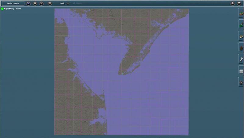
The cropped dem looked like this in Trainz before I filtered it. Distance between Cape May in NJ and Cape Henlopen in DE at the mouth of the bay is roughly 10 nm (18.5km). Scaled 1 to 10 this is 1.85 km on a kind of northeasterly direction between the 2 points in the scaled Trainz map.
[EDIT] PS. Vern, these are probably the same HOG files you're thinking of. There hasn't been an update to HOG since the 1.18 version in Nov 2002. Still writes out a UTC version of the .gnd mapfile that any version of Trainz up to TS12 can read directly. TANE and TS19 can read them if you rename the .gnd file to mapfile.gnd - the current required name.
I've actually used Transdem to get a 1 map unit to 10 real units scale model of the terrain of Delaware Bay Area. Z heights were left at full size for what I was using it for. The Trainz mapfiles were just an intermediate step since I have some scripts that work with the trs04 versions of them.
I used a similar approach to what geophil described. I had an ascii SRTM dem but just edited the column and row offset values (which were IIRC decimal degrees) in the header to 1/10 the real values -[edit] change cellsize shown below from 0.00083333333 to 0.000083333333. I may have edited the SW corner location to be the center of the region - I not sure. It worked just fine. As noted the geo coords are no longer correct. I loaded it into Transdem and used the route editor to draw a track route to filter the area I wanted. How you'd merge this with a different scaled terrain I don't claim to know at the moment. This was for a test map in an old age of sail game where the final cords are scaled 1 to 100 and not georeferenced in any way.
Here's the edited header in the SRTM .asc dem (3 arcsec data ~90m) for the southern part of the region:
Code:
ncols        1424
nrows        1355
xllcorner    -77.302041666667
yllcorner    37.579458333333
cellsize     0.000083333333
NODATA_value -9999
The cropped dem looked like this in Trainz before I filtered it. Distance between Cape May in NJ and Cape Henlopen in DE at the mouth of the bay is roughly 10 nm (18.5km). Scaled 1 to 10 this is 1.85 km on a kind of northeasterly direction between the 2 points in the scaled Trainz map.
[EDIT] PS. Vern, these are probably the same HOG files you're thinking of. There hasn't been an update to HOG since the 1.18 version in Nov 2002. Still writes out a UTC version of the .gnd mapfile that any version of Trainz up to TS12 can read directly. TANE and TS19 can read them if you rename the .gnd file to mapfile.gnd - the current required name.
Last edited:
Similar threads
- Replies
- 16
- Views
- 702
- Replies
- 21
- Views
- 807
- Replies
- 3
- Views
- 471
- Replies
- 10
- Views
- 666