Issues with a DEM...

Blutorse4792

Now T:ANE I can get into
So I've been working with a TransDEM generated route as of late, and everything was going quite well until I tried applying elevations and gradients to my track.

While portions of fill look more-or-less accurate, whenever I try to model cuts, they are showing up much, much deeper than they actually are IRL.
For example, when I apply the prototypical elevation to a high embankment over road it appears to be the correct height, but when I apply it to a much lower embankment over flat land, the tracks end up several meters underground.
I am using multiple company track charts in conjunction with overlay maps (and personal knowledge of the area in question), so I'm fairly sure that my measurements are not the issue here.

After discovering this, I started moving the overlay maps to check the ground underneath, and I've noticed several geographical features (creeks, hills, etc.) are missing.
I would chalk it up to the fact that many of them are either man-made or relatively insignificant, but they were included when I previously modeled the same area in MicroDEM (many of the man-made features are, for lack of a better term "geographically substantial" and have existed for 100+ years).

Did I screw up somewhere along the way when I generated the terrain, or should I try using a different DEM?
IIRC, I simply used the source in Dr. Ziegler's tutorial.
 
Last edited:
Well it will depend on the area but not all DEM is 100% accurate nor the overlaid mapping exactly accurate to where it should be either. Sometimes it is necessary to compromise and adjust the gradient to get the desired effect, or just resign yourself to a bit of hand carving to improve the terrain.

I had the same issue working on my latest route (narrow gauge somewhere in Eastern Europe) where Open Street Map has the river running half way up the hillside! I have also had to adjust the terrain as descending from the northern end of the tunnel at Sutorman I was faced with a 4% gradient which alternately created either 20m deep cuttings or 20m high embankments even after adjusting the height of the tunnel mouth. Of course this is exaggerated by not being able to specify the angle of the cutting etc. when smoothing the track, so most of my time this afternoon was spent applying road strips along the cuts and fills then smoothing those to get a more acceptable bank slope. It doesn't help that the DEM in this part of the world is only 70m resolution so a bit of averaging occurs.
 
I've had that kind of problem as well. The DEM in my area has inaccurate heights due to close proximity of rail embankments, hills, and tall buildings. When the data was processed, everything flattened out to nothing, causing all the details to disappear. I did some local observing, being in my hometown, and I was able to figure out what was wrong.

There's another pitfall too to watch out for. When overlaying older topographic maps on to a modern DEM, there are going to be more than a few anomalies especially if rivers, for example, have been channeled and redirected, or if a freeway was cut in where none existed. On the above mentioned DEM, I ran into the latter issue. The interstate was put in during the late 1950s and early 1960s and this cut swaths through a neighborhood, which didn't have the cuts or embankment from the interstate.

All this requires a bit of artistic license and some fiddling with the terrain to get the profile back to the landscape.
 
whenever I try to model cuts, they are showing up much, much deeper than they actually are IRL.
What precisely is your DEM data source?

After discovering this, I started moving the overlay maps to check the ground underneath, and I've noticed several geographical features (creeks, hills, etc.) are missing.
And what is your map data source?

While the final result can never be better than the geo data sources, sometimes there are better, i.e. more accurate sources, than the ones one might have currently in use.
 
The DEM in my area has inaccurate heights due to close proximity of rail embankments, hills, and tall buildings. When the data was processed, everything flattened out to nothing, causing all the details to disappear.

I had the opposite when in a more fanciful moment I thought about doing the Hong Kong Tramway. Despite the actual route of the trams being relatively level (as gleaned from the excellent top deck forward view rides on You Tube) when I came to look at the DEM there were peaks and troughs everywhere. This is due to the satellite registering the densely packed tall buildings as terrain and then averaging these into hilly terrain which simply isn't there in real life. Along with a number of other reasons this pretty much rendered the project impractical, though it would make a fascinating route to operate.
 
This issue was evidently the result of the particular DEM that I had originally chosen.
I was able to locate and acquire a much more accurate and detailed DEM from the USGS National Map site.
 
This issue was evidently the result of the particular DEM that I had originally chosen.
I was able to locate and acquire a much more accurate and detailed DEM from the USGS National Map site.
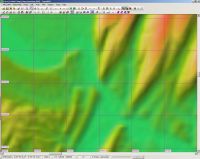
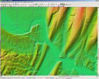
I thought as much. Some time ago I made a comparison between SRTM orbital and USGS NED terrestrial DEMs:
https://forum.transdem.de/viewtopic.php?f=2&t=24#p103

Click on thumbnails

SRTM 3 arc sec, ca 60 x 90 m:


USGS NED 1/3 arc sec, ca 7 x 10 m:
 
Back
Top