The Chicago Terminal District Project

After examining my DEM I've noticed that it is highly inaccurate for tracks. Using Google Earth I am grading the Metra UP-North Line, I have completed Kenosha to Waukegan.

If the DEM is right, I think Lake Michigan is flooding the city.

I decided to make my inaugural run from Kenosha to Waukegan (no signals or scenery). I'm using selihoff's track platforms as a stand in for the Metra Station until I am able to create a custom one.

Here's the train as it passes the low wetlands between Zion and Waukegan.

And here is the future location of the Waukegan Metra Station.
A UTM Tile (3d and 2d) is an object created by Transdem to provide a way of texturing the surface of the DEM beyond the resolution permitted by Trainz.
 
Ouch, maybe contact New Orleans, Louisiana for some flood pumps,,,,,,,all kidding aside that is heck of problem......
 
Since my last post, I've adjusted the elevation, gradient and spline points along the UP line from Kenosha to Ogilvie Transportation Center. When I reached the station I decided that if I wanted to get Metra trains running on the UP-North, I first needed to model the station and complete topo adjustments to UP-NW and UP-W. It has taken me a couple of weeks to learn a program that I feel comfortable with (i.e. Blender), here is the progress so far,

I am also seeking help in creating custom signals for turnout machines for this location.

Courtesy of Railpictures.net

Courtesy of Railpictures.net
It would be wonderful if someone could create the dwarf signals seen in these pictures. They seem to be 3 different versions of the same signal, the only major difference is that two of them have two white lights on top, which I believe serve the same purpose as a blue stop sign hung from the locomotive. One of those is on a stand so that they can be elevated above the platform. The signals next to each of the double slip control movement from any of the four possible movements. I've also noticed that the switch machines on the double slip turnouts are set up to only allow movement along one path (i.e., the double slip cannot act as a crossing or reverse switches). If anyone would be willing to design these for me I would be very grateful!
 
You truly have lost your mind, haven't you?

But as a huge fan of Chicago rail operations, I have no choice but to support this project regardless. Nice work so far!
 
I'm no 3d modeller but here's what I know.

1. you can attach track for the platform tracks but from what I understand point/turnouts and slips(single/double) can't be made with attached track.

2. those turnout motors from what I understand actually control each end of the single/double slips rather than each individual set of blades.
 
Sweeeeet!! I love in chicago!!! Ummm, Let me ask you one question other south for South Shore also Electric Metra Commuter?? just curios....

NKP:)
 
You should know the TANE has a maximum number of polys that it can show, it is in the millions but if you hit the limit Trainz will not show the rest. Down town Chicago could hit that.
 
@BlackDooley: You're probably right, I have lost my mind but that was a long time ago!

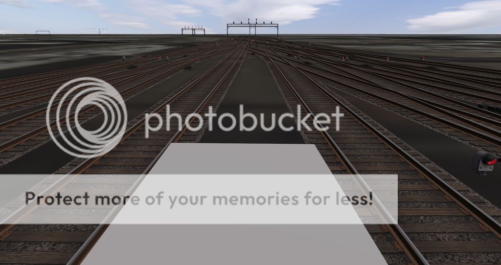
@drphlox: I've looked at instructions for attaching track to platforms, and at instructions for creating fixed track turnouts, I didn't notice anything that said the two could not be used concurrently. Also, in regards to the double/single slips, that is what I meant to say in my previous post, the problem is that none of the machines in Trainz currently support that action. If they were available it would help in areas like this where the driver, while sitting in the locomotive and looking out through the terminal throat and only seeing green/red arrows and being forced to use drive to/navigate or similar commands to navigate through.
.
@nickelplateroad: I'm working my way toward that line, I plan to complete all Passenger operations in this order, UP lines, RI Lines, Metra Electric & CSS&SB lines, and finally all of the lines out of CUS.

@whitepass: I knew that there were probably going to be limits on poly counts for various areas. For the downtown area I plan to mitigate that issue by only doing LOD 1 type detail, on the 4 passenger terminals and the CTA Elevated and Subway stations, and use basic cubes for most of the buildings (obvious exceptions include, Willis "Sears" Tower, Drumpf Tower, etc). I think my biggest problem will be in the area of BRC Clearing Yard, UP Global Yard II, CN/EJE Kirk Yard, with all of the different scenery, locomotives and railcars in the scenes. I have no illusion of completing this route to a fully operational route with passenger and freight traffic until at least the next version of Trainz is released and I get a faster computer. The route is already too large to be exported as a CDP, this limit will probably increase in the near future based on the sizes of other items that I have downloaded off of the download station.
 
One thing about the dems for Chicago is your gonna take big hits., that's why I went with just manually measuring and configuring various maps., good luck with this project.
Another thing I also been doing is deleting non track baseboards you will recover a lot of frame rates and avoid loading and crashing times...I went from at least 15mins loading time in TS12 to 30-45 seconds in Tane...

Dave =)
 
Last edited:
Snip

@drphlox: I've looked at instructions for attaching track to platforms, and at instructions for creating fixed track turnouts, I didn't notice anything that said the two could not be used concurrently. Also, in regards to the double/single slips, that is what I meant to say in my previous post, the problem is that none of the machines in Trainz currently support that action. If they were available it would help in areas like this where the driver, while sitting in the locomotive and looking out through the terminal throat and only seeing green/red arrows and being forced to use drive to/navigate or similar commands to navigate through.
.
Snip


@Bradleyeed:

If the Railsim team could not do it with all the stations on the Settle & Carlisle, what makes you think you can?

The point is that your not the first to try to integrate a set of points in middle of a platform or as part of a interactive station and so far no one has been successful.

As for the issue with navigating through a station throat, perhaps you should check out the Potteries Loop line website (http://www.potteriesloopline.co.uk/) for the Shunt sequencer rule.

SHUNT SEQUENCER rule and HUD
The 'Shunt Sequencer' rule manifests in-game as a heads-up display panel (HUD) and is intended for use by player-driven trains when shunting at various locations. For each shunt location, there are a number of “movement” controls shown in the HUD. A “movement” consists of junctions, signals and/or uncoupling points that are controlled in order to complete one shunting movement by the player-driven train. This allows the junction switch directions, signal states and uncoupling points for each movement to complete the session to be set by clicking a single item.


ROUTE SELECTOR track mark and SET WAYPOINT command


A route selector is an intelligent trackmark and marks a step in the journey taken by the train. The required path to the destination of the train is chosen at the beginning of the session by adding Set Waypoint commands to the driver schedule. As the train reaches each route selector, a decision is made how to set the path ahead, depending on the active waypoint and the information stored in the route selector. By varying the waypoints the train can be made to choose different paths through the rail network, provided that the route selectors have been set up to handle each case.
 
@mtldrm38: I've noticed that problem and depending on location I will probably delete some baseboards. I used a 1 baseboard radius when I created it with TransDEM because I didn't want it to be too large and at the same time a 0 baseboard radius meant that in some locations the track would be less than 10 meters from the edge.

@drphlox: It was not my intention to say that I can do what no one else can. I have examined the Settle & Carlisle Route and it is my understanding that their route was designed TS2009:WBE and the only upgrades for TANE revolve around items that had errors. It is obvious that changes were made between the 2 platforms, and it is my hope that it is now available. Also, if 9 years of working on this project and 5 years of engineering school have taught me anything, anything is possible with time, patients, knowledge, understanding, and of course alcohol. So if it turnouts that I can't do it now, I'll adjust, move on, and come back after the next version of Trainz is released.
 
The progress is slow going, this is the first route that I've created in Trainz and the Ogilvie Transportation Center is the first asset that I am creating. I've contacted SAXRT about getting copies of those items but I haven't heard back yet.
 
Gadzooks this is something else. I was looking around for a model of just the Clearing Yard, to attach to my Chicago-Joliet model, and what do I find? Ay carrambah! Someday perhaps technology will catch up with this epic route and we'll be playing MultiPlayer Chicago Metro some day. I'll play Union Station South dispatch.
 
Yeah, it is! The progress has been very slow this year. Among other things going on in my life, and a series of bugs (After merging layers almost all track objects were hidden and needed to be deleted, a series of crashes caused approx 20% of the baseboards to lose their DEM information and revert back to a flat board) have seriously hampered my progress. I have however made significant progress in the following areas:

Basic models (Untextured & non-detailed mesh) of every Metra station except Ogilive on the Kenosha Sub, and most of the stations on the Milwaukee District North and North Central Service Lines in Lake County, IL
Basic models (Untextured & non-detailed mesh) of the modeled industries in Kenosha County, WI and the ZION Nuclear Power Plant Demolition Site and the NRG Waukegan Power Generating Station
I'm compiling a database in Microsoft Access of the route, which includes but not limited to:
over 700 businesses that are directly rail served
4 hump yards, 7 medium to large classification yards
Locomotive and rolling stock rosters
railroad crossings
 
It has been a year of hard work and some major setbacks but I'm about to take 2 weeks off to do flood repair work in Beaumont, TX, so I thought that I would bring you up to date.

First, the setbacks, since the implementation of TANE:SP2, The game crashed about 5 times and at some point, during those crashes, the topography disappeared from around 20% of the route. I attempted to recover some of the topography under already corrected track elevations but the game would crash and the topo would be gone again. I decided to surrender the fight and temporarily flatten every location on the route which is turning out to be very beneficial.

Now the good news, I have completed the x,y components of all mainline tracks, non-industry tracks, and yard tracks on:
the Union Pacific Kenosha Subdivision, Milwaukee Subdivision, Harvard Subdivision, McHenry Subdivision, Geneva Subdivision (OTC to Villa Park) including, the California Ave. Yard, Proviso Yard, Waukegan Yard, Keeler Ave. Yard, Bryn Mawr Yard, Des Plaines Yard & North Ave Yard.
the Canadian National Waukesha Subdivision, Waukegan Subdivision, and Leighton Subdivision
the Canadian Pacific C&M Subdivision, Fox Lake Subdivision, Elgin Subdivision, Bensenville Yard, Galewood Yard, & Schiller Park Yard
IHB Norpaul Yard and main line from the CP to just south of the UP Geneva Sub
BRC mainline from the CP to just south of the UP Geneva Sub

I have also created 12 1st phase industries (mesh and track, non-scripted yet) (10 in Kenosha County, WI and 2 in Lake County, IL)
25 exclusive stations on the UPN
21 exclusive stations on the UPNW
Clybourn Station shared between UPN, UPNW
10 stations on the UPW
20 exclusive station on the MDN
3 exclusive stations on the MDW
15 exclusive stations on the NCS
7 shared stations between MDW & NCS
and Western Ave Station shared between MDN, MDW, NCS

I have gotten a lot of inspiration from watching fellow Trainz users, on Youtube, esp. Approach Medium (ACBDFAQOZ) & Trainz Rail Operations (User unknown).

I currently have 70 interlocking towers (with 1 more signaled and junctions placed but will have over 100 paths, and 2 more waiting for more signal information before I place)
Currently, 1093 paths assigned to the towers with an average of 15.6 paths per tower.

In this screenshot, the red jagged line represents the boundary of what I've done (No scenery)
https://photos.app.goo.gl/yMhn7fOyw7hx2YBA2

Here is a map view of UP Proviso Yard and CP Bensenville Yard
https://photos.app.goo.gl/sRRocRYZrUhCbAez2

UP California Ave Yard and CP Western Ave Yard.
https://photos.app.goo.gl/Legy28FB48ZrZVLg1

Tower A-2
https://photos.app.goo.gl/GabkmQniLKWIf8rk2

IHB Norpaul Yard
https://photos.app.goo.gl/i3QmyaJP4m7Emv1b2

UP Proviso Yard
https://photos.app.goo.gl/F8ChZuXYha7Dgj9B3
https://photos.app.goo.gl/LSWXLxOIwr0N8BU43
https://photos.app.goo.gl/xvHi4RcBrUNn9Por2
https://photos.app.goo.gl/rg7LywZvQPy2cTM33

CP Bensenville Yard
https://photos.app.goo.gl/sSieLIv09MiDqtId2
https://photos.app.goo.gl/pwX4NTa0eUpCovcF3

Short-Term Goals following my hiatus:
Complete the Geneva Subdivision out to Elburn
Complete the Elgin Subdivision out to Elgin
Start & Complete the Rockford Subdivision from the Geneva Sub through Elgin
Advance the Leighton Subdivision down to the Geneva Sub
Start and place all industries upon the completed lines.

Medium-Term Goals:
Advance the relative lines counterclockwise around the city from the Geneva Subdivision to the BNSF Chillicothe Sub & CN Joliet Sub from Chicago down through Joliet and including UP Global Yard 4, CN Joliet Yard, BNSF Logistics Park
After that point, the progress will slow down even more significantly then it has been going, because of the density of yard tracks, industries, and Mainlines.

Acknowledgments, My goal for this project is to have some combination of Multiplayer and large scale automation. I know from Trainz Rail Operations creation a fully automated UP North Platte Hump Yard that this type of operation will be possible but not on my current laptop computer before I reach that point I will need a more advanced desktop computer. At this point, it is easy to say that this project will be at least another 5 years in the making, so don't look for this anytime soon.
 
I'm still hard at work on this route, I've completed all mainline tracks and documentation on the Geneva, Harvard, McHenry, Milwaukee, Lake and Kenosha Subdivisions. As well as all other mainline tracks North of the Geneva Subdivision and the CN Leighton Subdivision down to Joliet. I finally went back to my model of Ogilvie Transportation Center and I placed a non-functioning version into the route. I upgraded to TRS19 and well I'm 95% impressed with this version, I'm not sure if it's the JR signals in TRS19 or the way that I'm using them but random signals go dark as soon as the lead vehicle in a train passes them, without being set up for approach lit, and with O4 and O5 signals the game will temporarily freeze after either the lead vehicle passes or the trailing vehicle passes. Before you point out that it could be the number of polygons on the screen when the signals change, I've tested that theory by sending a train down a route and focusing on another train 40 miles away from the train that is testing with the same result.


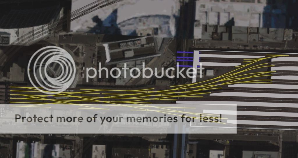
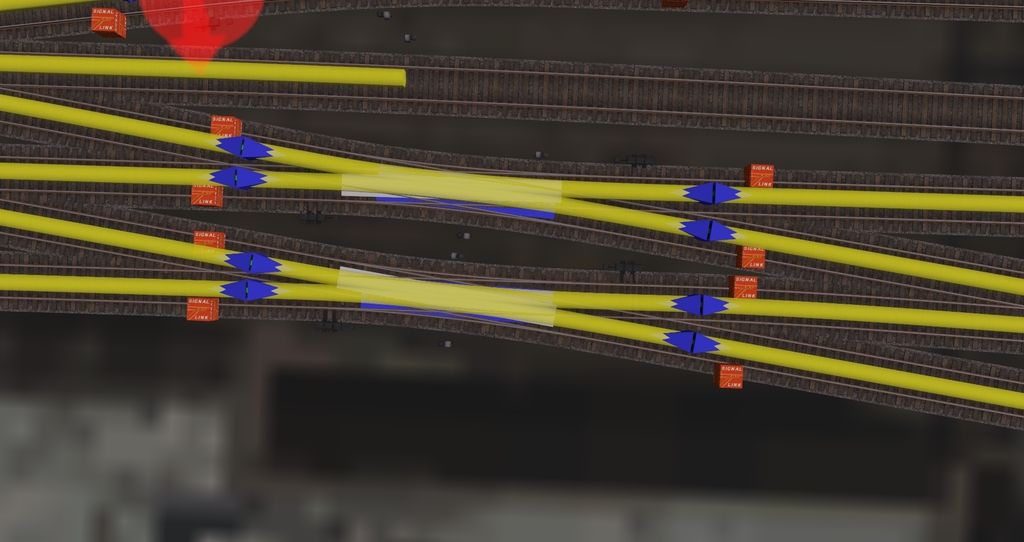
Here is an overhead view of all of the routes at the Lake St. Interlocking on the North side of the Ogilvie Transportation Center. These routes are all inbound and are split between 2 towers with 1 having 56 paths and 2 having 58 paths. I've tried multiple ways of setting up these towers, including single routes from one end to the other for each possible path and that would only allow 80% of the paths while requiring at least 6 towers in each direction 7 of the Double slip switches are isolated into there own path sets, as shown below.

The Signal links are used to link the entry signal of the following path to the visible signal on a section of invisible track, to show phototype indications through the double slip.

I can't wait to get trains up and running through here so that I can replicate different Youtube videos that I used for reference.
 
I created a gofundme page to help fund this project and there are rewards for helping out. Tier 1: Brakeman $5
Communicate with me
Access to prototype track charts, rule books, time tables

Tier 2: Conductor $10
Tier 1 items
Access to custom track charts like the ones pictured above

Tier 3: Engineer $15
Tier 2 items
Access to route and custom content, with monthly update

Tier 4: Dispatcher $20
Tier 3 items
Assistance in creating session

Tier 5: Supervisor $25
Tier 4 items
Get your name on the model - you choose, 1) a model named after you, or 2) at least one model of you somewhere in the city

check out my gofundme at:
gf.me/u/zbypzx
 
Back
Top