How good are DEMs for UK terrain?

mezzoprezzo

Content appreciator
.
I’ve seen some really good results for the US; at least I think they’re good, because I don’t know the areas to compare the results. Dermmy’s prototypcal routes come to mind (where are you Andy?). He has stated in the Forum that some of his work was created using DEM software.

However, I’ve not knowingly seen images of any UK Routes which have used a DEM for creating the basic landscape.

I’ve been building the Swanage Railway, raising the Purbeck Hills by hand over basemaps. Progress is extremely slow. Being a bit of a perfectionist I’ve been hand sculpting the terrain so that it matches reality as closely as Trainz will allow on the 10m grid.

I’m tempted to have a go at building a DEM, but have been put off by the apparent complexity of learning how to do it. My track record at sorting out anything too technical is poor! I also understand that DEM landscape creation will only be as good as the quality of the basic data, and that the UK data won’t allow as precise a creation as might be achieved from other mapped areas of the world.

So, I don’t want to embark on a technological voyage which will possibly be abandoned, unless the pursuit of the end result is worthwhile.

Does anyone have screenshot examples of a Trainz Route created from a UK DEM, preferably of a well known landscape with recognisable hills, from which comparisons can be made with the real area?
 
UKTS has some DEM based on the Ordnance Survey, most of it at 30m res some at 20m res. It's not perfect but probably better than the standard NASA SRTM and certainly way better than trying to craft the terrain by hand. You would need to join UKTS to access the file library and with the limitations they have on downloading probably need to buy a one month premium membership. However once you've grabbed the DEM, it's yours for life (or until you accidentally delete the files!!).

So far as getting the DEM into Trainz, I can do no better than again recommend Transdem. This will also overlay maps with a choice of Open Street Map, the Windows Live access to the OS sheets that includes 1:25,000 that even has individual field boundaries or historical OS mapping from Sabre.
 
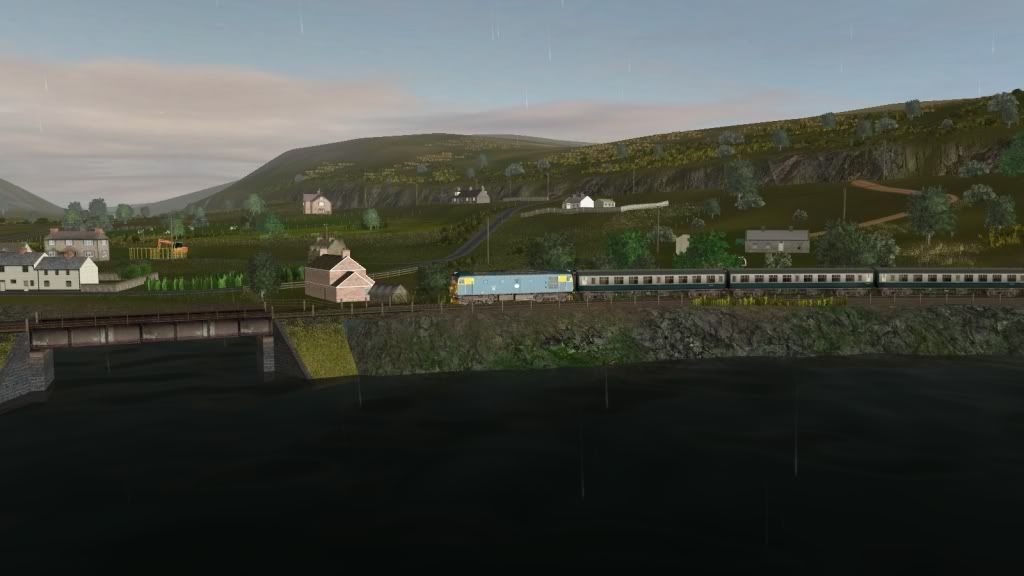
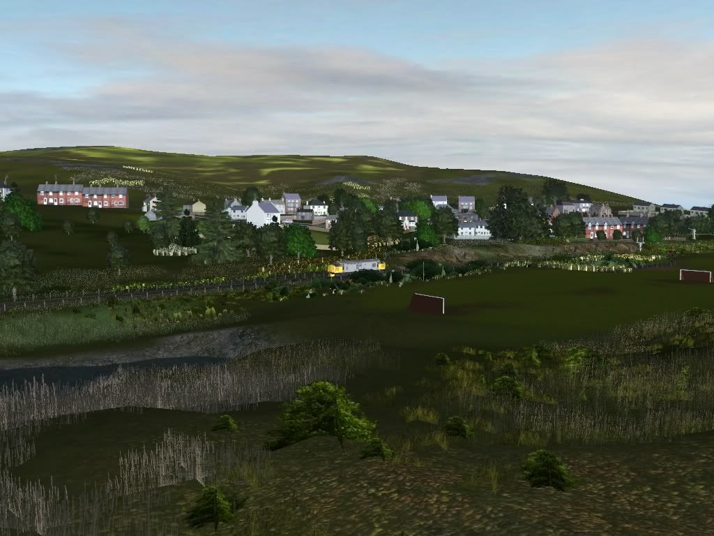
Do you mean by using the likes of TransDEM? The UK data is good enough to be more than passable. Below are a few shots of a route I have been working on for what seems like forever and created using the free DEM data on the OS site. There are good tutorials on the TransDEM forum with which I managed to fathom how to get the data into Trainz.

This is Duirinish on the Inverness to Kyle line.


Erbusaig


North of Kyle of Lochalsh.
 
.
I’ve seen some really good results for the US; at least I think they’re good, because I don’t know the areas to compare the results. Dermmy’s prototypcal routes come to mind (where are you Andy?). He has stated in the Forum that some of his work was created using DEM software.

However, I’ve not knowingly seen images of any UK Routes which have used a DEM for creating the basic landscape.

I’ve been building the Swanage Railway, raising the Purbeck Hills by hand over basemaps. Progress is extremely slow. Being a bit of a perfectionist I’ve been hand sculpting the terrain so that it matches reality as closely as Trainz will allow on the 10m grid.

I’m tempted to have a go at building a DEM, but have been put off by the apparent complexity of learning how to do it. My track record at sorting out anything too technical is poor! I also understand that DEM landscape creation will only be as good as the quality of the basic data, and that the UK data won’t allow as precise a creation as might be achieved from other mapped areas of the world.

So, I don’t want to embark on a technological voyage which will possibly be abandoned, unless the pursuit of the end result is worthwhile.

Does anyone have screenshot examples of a Trainz Route created from a UK DEM, preferably of a well known landscape with recognisable hills, from which comparisons can be made with the real area?

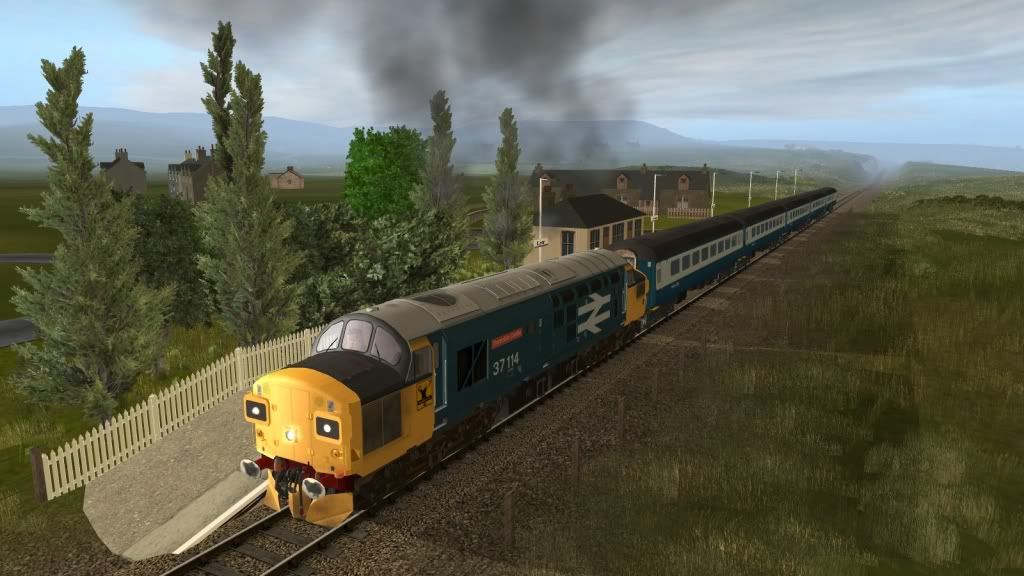
There's always my route, done using microdem / Hog and a lot of measuring things......... http://forums.auran.com/trainz/showthread.php?56167-Ffestiniog-and-Welsh-Highland-WIP 5m grid I'm afraid. And it probably won't mean a lot unless you have spent a lot of time in North Wales

Far better digital data is available now from Ordnance Survey's open Data which is a lot more accurate, I started this 5 years ago and had never even heard of Trandem then, so I've had to do a lot of sculpting, for which you need some artistic talent, which in your case is well above average so I can't see that being a problem.
 
I know of a couple of people who are using UK DEM, flip me an email jwhelan0112 gmail.com if you you want to take it further.

Thanks John
 
Likewise Mezzoprezzo, I am also seeking advice on how to model the Purbeck hills, especially around Corfe Castle. That's the bit I'm dreading most (for those that don't know, I'm creating my own version of the Swanage Railway). I may invest in DEM, but I need to learn how to use it first! Anyone got any advice on TransDEM and it's ease of use?
Many thanks,

PortLineParker
 
Regarding TransDEM...

TransDEM is a bit overwhelming at first glance with it's host of buttons and stuff all over. However, Roland's (GeoPhil) tutorials and forum have made the program relatively easy to use. In many instances, it isn't even necessary to touch half of the buttons as they are not needed for the basic operations.

It truly is a great product at only $34.00 US (around 28 Euros). All I can say is after you use it once for terrain, you'll find even the best of your hand worked terrain to look, well hand worked! :)

John
 
This is a DEM of the whole of (flat!) Norfolk, England. If you know Norfolk, the DEM clearly shows the higher points, the river valleys and the area that is at, or below, sea level.

Image-2_zps8b9fc52a.jpg


TransDEM does have a learning curve but, once mastered, it is possible to create a large landscape fairly quickly. As far as detail goes, it is not going to place embankments and cuttings because the ground is averaged out but it is possible to work out exactly where you are if you compared it to a map showing contour lines. The ability to place railway lines in the correct place from a range of mapping sources, be it modern-day or historical, makes the process quite rewarding.

This is a screenshot of Wells-Next-The Sea, the minimap showing the textured baseboards and the map behind being a UTM (Universal Transverse Mercator) object, used to gain more clarity in a smaller area (1000m). As you can see, the embankments are clearly marked on the UTM.

Wells_zpsceabf63b.jpg
 
Last edited:
If you want an example of how finished routes look using the UK DEM and Transdem, check out my Dalmunzie and Swindon to Cirencester routes in the file library.

@pfx - You've got me drooling over the keyboard with those screenshots mate!
 
My WCL sections are made using TransDem, that is most of section 1 from Paddington to Reading (I didn't know about TransDem when I began it) and all of section 2 Reading to Westbury.

angela
 
UKTS has some DEM based on the Ordnance Survey, most of it at 30m res some at 20m res. It's not perfect but probably better than the standard NASA SRTM and certainly way better than trying to craft the terrain by hand. You would need to join UKTS to access the file library and with the limitations they have on downloading probably need to buy a one month premium membership.
Vern, with TransDEM you wouldn't want the pre-processed UKTS DEMs and better go for the Ordnance Survey original source instead. IIRC, that UKTS data was prepared to comply with the geo data restrictions of RS/RW and - as with all conversions - will have lost some detail in the process. Furthermore, Ordnance Survey recently has replaced "Land-form Panorama", the source for UKTS, with the improved "OS Terrain 50" set.
 
Last edited:
@pfx - You've got me drooling over the keyboard with those screenshots mate!

Sadly, it won't be released for a good while yet. It's taken about 2 years to get the first 8 miles done. 70 odd to go! That said, I've been neglecting it of late as I got so sick of the sight of the thing. I need to get a couple of things out the way and then I'm going to make a concerted effort...
 
That said, I've been neglecting it of late as I got so sick of the sight of the thing....

I hear you - lost count of the projects I've started recently with great enthusiasm, which have fallen by the wayside.

@Roland - I will check out the updated OS data next time I start a UK route.
 
The problem is that UK Ordnance Survey Open DEM/DTM Data better than the freely available 30m resolution will normally cost you quite a bit, unless you have an academic account. Malc, what resolution data did you use? If I may ask, did you have to pay for it?

Also, as has been pointed out here, the higher the resolution the data, the larger it becomes (as a square law) in GigaBytes. The higher the resolution, the longer it will take to process and, in the end, a Windows operating systems may be unable to handle the memory load and cause TransDEM to fail, unless you deal with it in small chunks.

Peter.

--

There's always my route, done using microdem / Hog and a lot of measuring things......... http://forums.auran.com/trainz/showthread.php?56167-Ffestiniog-and-Welsh-Highland-WIP 5m grid I'm afraid. And it probably won't mean a lot unless you have spent a lot of time in North Wales

Far better digital data is available now from Ordnance Survey's open Data which is a lot more accurate, I started this 5 years ago and had never even heard of Trandem then, so I've had to do a lot of sculpting, for which you need some artistic talent, which in your case is well above average so I can't see that being a problem.
 
Last edited:
Malc, what resolution data did you use? If I may ask, did have to pay for it?

Nothing as good as 30m this was 5 Years ago, came from a US site and it was free.
I have an OS open data one I ran through Microdem just to see if there was a difference, there is, it's far more accurate less filling in and rounding off, as I'd already carved out my existing one I'm sticking to it.

I have though downloaded all the OS open Data stuff for future use, must really get round to buying Transdem, using the Microdem Hog method for the UK is a pain.
 
Peter brings up an important point which now has become an issue for us in the US. Our National Geological Survey has kindly made all DEM downloads into huge, as in 430-plus MB sized zip files. Once extracted they are about 20% bigger. These are large sweeping 1 arc-second regional chunks no matter what smaller area you choose. The problem then becomes a processing issue once we download them. TransDEM runs out of memory when we attempt to merge two DEMs. This now becomes a puzzle game as we figure out the best way to chop and save what we need for the project.

John
 
Peter brings up an important point which now has become an issue for us in the US. Our National Geological Survey has kindly made all DEM downloads into huge, as in 430-plus MB sized zip files. Once extracted they are about 20% bigger. These are large sweeping 1 arc-second regional chunks no matter what smaller area you choose. The problem then becomes a processing issue once we download them. TransDEM runs out of memory when we attempt to merge two DEMs. This now becomes a puzzle game as we figure out the best way to chop and save what we need for the project.John
Ordnance Survey Open Data DEMs/DTMs are 10 x 10 km, small enough chunks not to cause any memory trouble, but you will need quite a few to cover the extent of your route project.

With USGS NED there wasn't any memory problem while we could download tailor made DEMs from Seamless Server. Tailor made usually meant rather small. Now we are only getting 1 x 1 degree files, often far too big for our route. We only need a tiny part of those, so we have to make them smaller ourselves. To do that, TransDEM always had the scissors tool to cut bits off. New TransDEM 2.4 also offers a load filter which enables you to read only a subset of the DEM into memory.

Coming back to UK DEMs/DTMs, we have three different sources for free data: SRTM 3 arc sec, ASTER GDEM 1 arc sec, and O/S Terrain 50m (replacing Land-form Panorama).

While ASTER GDEM nominally has the highest resolution (ca 20 x 30 m), the true resolution is significantly lower, and ASTER data usually comes with a few artefacts and almost always rather uneven terrain. Both SRTM and ASTER are orbital data while O/S terrain 50 (and Land-form Panorama) is terrestrial. The satellite sensors do not always recognize bare ground, so the result is more like a DSM (digital surface model), with forests and buildings included, unfortunately in a rather blurry manner. Terrestrial DEMs are normally free of those mostly unwanted sculptures.

For this reason I would always prefer 50m terrestrial DEMs over nominally higher resolution orbital DEMs. If you have TransDEM, you can easily make your own assessment. Load the various DEMs one by one and also a georeferenced O/S topographic raster map 1:25,000 of the same area as a reference. Switch on DEM contour lines. Then compare the DEM contour lines, drawn by TransDEM, with those on the raster map.
 
.
Thank you to everyone who responded with both artistic results and technical knowhow.

If you want an example of how finished routes look using the UK DEM and Transdem, check out my Dalmunzie and Swindon to Cirencester routes in the file library. ~snip~

What is, and where do I find, the file library please?


I like what pfx has done with the Scottish line. I don’t know the area at all, but I’ve just spent some time looking at Google Earth and other images of the area to see how it really looks and the results achieved on the Trainz baseboard look really good.

I’ll need to review my technical abilities and consider what to do.

Thanks again all!

Cheers
Casper
 
Just to add, Casper, my Lavenham route was done in TransDEM. Suffolk is pretty flat, but there's enough variation for the DEM to make the whole thing just so much more realistic than by hand let alone flat baseboard.

The latest version of TransDEM is very straightforward to use, if you follow the tutorials, and it's pretty easy to generate realistic looking terrain overlaid with an historic OS map. I'd say, go for it!

Paul
 
Back
Top