Phoenix/METRO Light Rail

acelejalde

Urban Transit Developers
Hello all!

Here's the beginning of Valley METRO! I started with the storage yard off of S. 48th St, and worked my way to Sky Harbor/44th St station. Most of the route will be built with custom scenery items (street signs, stations, signals)--below are the first of many screenshots highlighting my progress. These shots are displaying one of the intersection signal/signs combo I have finally gotten to work (they are renameable!)

Sign1.jpg


Reverse side of sign:
Sign2.jpg


Enjoy! More updates to come this weekend!

-A :wave:
 
Last edited:
Most impressive

Very impressive start to the layout :D .

The custom content is incredible too and I can see it finding a home in my layout somewhere :).

Keep up the great work! :D

Regards,

Johan
 
Updates!

Hey all--

As you know, the first few screenshots had some tracks that were placeholders until I refined my own catenary tracks and such--and I must say that I've finally uploaded them and put them in the layout!

For those not familiar with the Phoenix layout, it's a one-line route that runs about 20 miles from NW Phoenix south-easterly to Mesa. I started with the maintenance/storage facility at S 48 St, and worked my way west to 44 St, and then east all the way into Tempe. I'll be completing the eastern leg of the system first because it's a whole lot easier (once you clear ASU, it's a straight route all the way to the end).

Below are some pictures (very bare bones, no scenery) of what I've got done so far. Little details such as signals, streets, signs, catenary poles and the like will be added in almost last. The first priority is trackwork and stations. These stations are built in items from TS09, but are placeholders for now until I get my stations in the game (since the platform length is a standard 275', these will be objects that can have invisible stations attached to them!

Maintenance/Storage Facility:

YardLeadsEB.jpg

YardFishHook.jpg

MaintenanceShop.jpg

SandingPlatform.jpg

YardOverhead.jpg


Tempe:

CenterPkwyStation.jpg

TempeTownLakeBridge.jpg

AshAvXing.jpg

MillAv-3St.jpg

VeteransWayStation.jpg


Enjoy!

-A
 
Looks really good! PS. did u made the canopy (on 3rd and 4th shots)? if no, then who made it? is it for download?
 
Eastern Leg Update

Canopies are built into TS 2009. I think it's "roof gmp" or something along those lines. Again, those are *somewhat* similar to what Phoenix has, but they're just going to be placeholders for the time being.

I've finished the eastern leg of the route all the way to Sycamore/Main St in Mesa, including all stations, alignment crossings, signals and catenary poles. I'm using the red poles for Tempe/Mesa and the blue/green ones for Phoenix as a little hint for those of you not familiar with the system, so you can tell which city you're in.

Below are a few night time shots of areas of interest to me (without scenery there's not much to go on), but they highlight how the catenary poles look, along with the signals I've made and their respective name plates. I tried to have them in one asset, but the multi line script didn't work, so the signals and the name plates are two different track objects.

I'll work on the western leg during this week, hopefully making it to at least Central Av (which is 44 blocks east of where the west leg ends [44 St station]). It's two one-way street sections eastbound along Jefferson and westbound along Washington and they have some funny (and interesting) alignment crossings going diagonal along the tracks, so that should be fun to hammer out in Google Earth. I'm making some road splines/intersections just for this route, so expect those soon, along with the new Phoenix signs (wider), and Tempe traffic lights.

Yard Entrance Interlocking Signals (heading EB)
YDE2-8.jpg


Yard Exit Signals (10 is WB, 12 is EB)
YDE10-12.jpg


Dorsey Ln Interlocking- The unilens green means it's a manually thrown switch, not controlled by the tower. The signal on the wrong-railing track is supposed to be a blinking green to signify it's a wrong-rail set-switch. I haven't worked that out yet. (Green is their only indication)
DorseySigs.jpg


Dobson Rd Signals-
DobsonSigs.jpg


Mesa tailtracks, end of the line-
MesaBumpers.jpg


I promise a little more scenery the next time around guys--sorry to keep you waiting!

Enjoy!

-A :wave:
 
Traffic Lights/Signs

Just a little update--I've completed the first beta set of traffic lights to use with my route. The coronas are static for the time being, which is why there are "red" and "green" versions of each sign; while I figure out how to make them ATLS-compatible, this is what I'm doing. Each street sign is re-nameable (the larger signs and the Tempe versions have two editable lines of text for street names), and has the capability for both the street name and block number to be editable--thanks to Retro00064 for providing the script, originally for my BART Mileposts, and allowing me to tweak the script as needed (it's used in NYCTA and for other BART signs as well). I'm working on some other editable signs as well, for freeway routes and stuff, which will be used for a fictional urban route as well as fictional extensions of the Phoenix light rail that I plan on constructing in the future. Enjoy the screenshots below and as always, I will keep everyone updated!

Phoenix Signs:

PhxTrafficLight1G.jpg

PhxTrafficLight1R.jpg

PhxTrafficLight2G.jpg

PhxTrafficLight2R.jpg

PhxTrafficLight3G.jpg

PhxTrafficLight3R.jpg

PhxTrafficLight4G.jpg

PhxTrafficLight4R.jpg


Tempe Signs:

TempeTrafficLight1G.jpg

TempeTrafficLight1R.jpg


-A
 
WHERE IS THAT Y ????????? in tempe? I have never ever ever seen a Y on the northern (north of Tempe Town Lake) half of the system. Although I have seen a passing track up here XD.
Looking Good, I cannot wait to see this work of art finished :)
What are you using for the units themselves? and where did you get them?
 
Last edited:
looks good, but this will be animated? the stoplights? that might need scripting.
acelejalde said:
The coronas are static for the time being, which is why there are "red" and "green" versions of each sign; while I figure out how to make them ATLS-compatible, this is what I'm doing.

^ This.

Great progress, btw. Will this content be posted on DLS, or will you put it on Mediafire like the NYCTA content?
 
out of curiosity will you be making the old amtrak station that's now a macayo's that's just the other side of TTL (Tempe Town Lake in this case)?
 
Updates & Answers

^ This.

Great progress, btw. Will this content be posted on DLS, or will you put it on Mediafire like the NYCTA content?

I will be hosting it on MediaFire for the time being, like the rest of my content. BStyles and I are in the process of developing a website to host all of our creations, so that way people can find everything NYCTA, BART & METRO related in one spot. In addition to those three agencies, the rest of our custom content would be hosted on the site, and I believe all of our stuff presently on the DLS (he and I have 4-5 things each on there) would be updated and moved to the new server. No release date on website yet since it's still in its infancy.

WHERE IS THAT Y ????????? in tempe? I have never ever ever seen a Y on the northern (north of Tempe Town Lake) half of the system. Although I have seen a passing track up here XD.
Looking Good, I cannot wait to see this work of art finished :)
What are you using for the units themselves? and where did you get them?

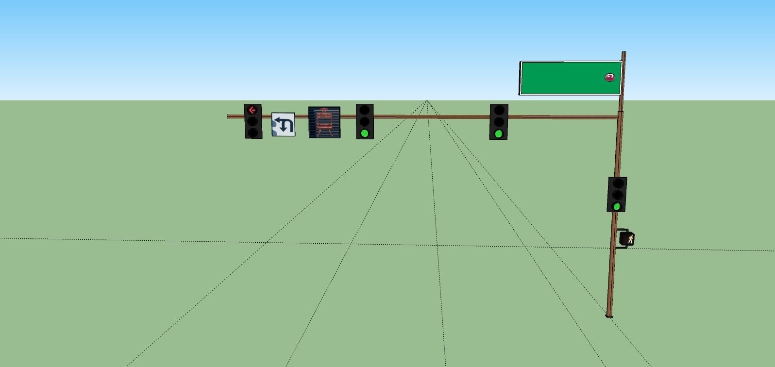
The wye is east of 51 St & Washington, right before the Loop 202 crosses overhead. Each track goes in a different direction; signal 10 controls the lead coming in from the west (Montebello/19) and signal 12 controls the lead coming in from the east. Beyond where those two leads connect to the mainline there are single crossovers immediately after to switch back to the correct direction. It looks something like this (the entire layout is called the "YDE Interlocking", for "Yard Entrance"):

DSCN0509-1.jpg


The above picture is from one of the wall maps at the Yard's main office.

Oh, and I almost forgot, there is a wye at 11 St, between Washington & Jefferson, to allow trains in either direction to turn back both ways.

out of curiosity will you be making the old amtrak station that's now a macayo's that's just the other side of TTL (Tempe Town Lake in this case)?

Yes, I'll be doing that, since I'm including the freight line from where it crosses 48 St below Washington, all the way to about Ash Av/University.

Oh, and right now I'm using Denis_Fr's Dublin & Orleans Alstom Citadis trams (on the DLS under Denis_Fr). If you carefully look through the asset folder, there are three config files, I deleted two of them, and kept the one with the destination sign script included. In the session rules, you can make your own table of destinations, type anything in, and in driver select it as the destination--pretty cool in my book. I might ask how to implement that into my METRO stock.

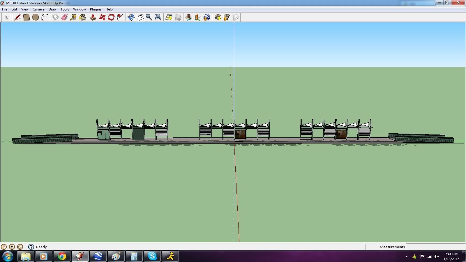
Oh and I almost forgot. Island station is done! Now just need to modify them for the two side platform version (Mill Av), side & island (Veterans' Way), and single side platform version (along one-way street sections).

IslandStation.jpg

StationPosters.jpg


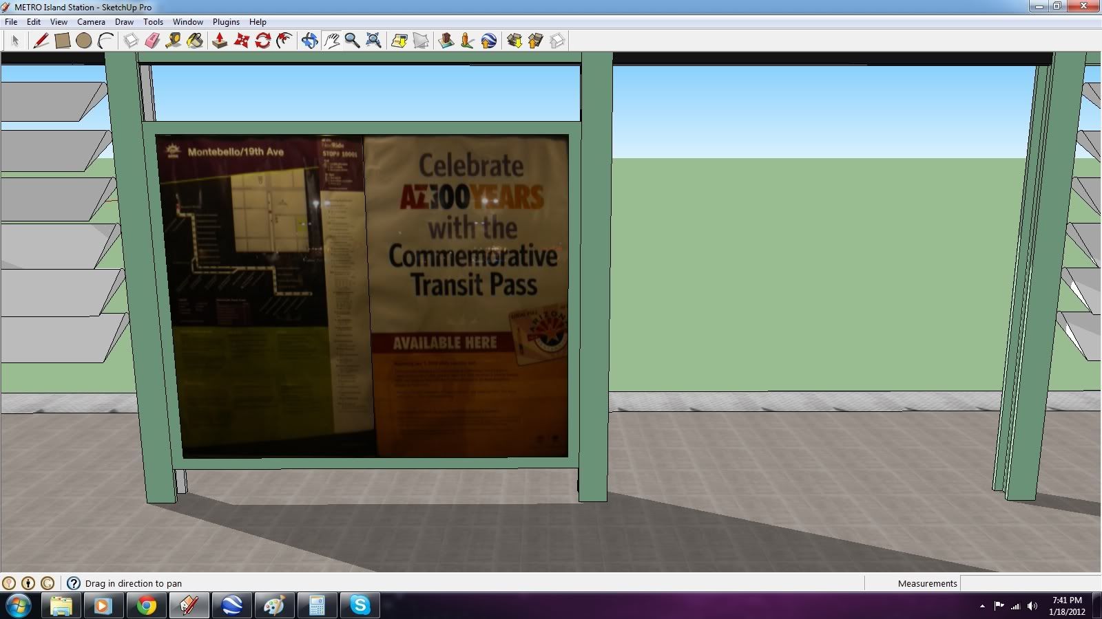
The posters are photos I took an hour ago at Montebello/19th Ave; getting the white "sails" on top of the station took hours of head-banging. I couldn't figure out how to curve them for the longest when it's really simple in sketchup. Just select the line connecting the two layers and drag. Sometimes the simplest things escape me :hehe:

Enjoy!

-A :wave:

(Also, any other questions are definitely appreciated as long as they're on topic!)
 
Last edited:
I expect that you'll be adding passenger attachments (a.passXX) to the mesh when you import, and that you'll be reflecting that in the queues.
 
I look forward to this Acela every time I see a new picture, THIS LOOKS AMAZING!!!!!!!!!!!!!!!!!!!!. I I did completely forget about the 11th st wye. I was actually referring to the pic that both the NB and SB tracks switch into.
another out of curiosity, if it ever gets planned do you have any intention of running this up to Dunlap?
 
Yeah, I do. I submitted a small study I did on potential routes (for their regional 2030 plan) to the General Manager when I met with him in October, and he was impressed. I'm still not sure how they (METRO) will build it past Dunlap to Metrocenter. I have some ideas (costly, i.e. an underground portion past 23rd Av), which I'll implement, because let's be honest--a grade crossing at that horrible exit at I-17/Dunlap, AND trying to navigate the Metrocenter parking lot? It's going to be a disaster unless it's either el (cheaper) or subway.
 
Ive got an idea of how to do it but it's insanely weird. The problem I've seen with a subway tunnel to Metrocenter is getting it low enough to go below the Central Arizona Project Canal is just not cost effective. If I had my way as to how the line eventually went to anthem, I'd put a double track Wye at 19th and dunlap to have the main trains run to metrocenter across the I-17 overpass and go across the canal at the street just past Castles and Coasters (very rarely used) and expresses run up further on 19th avenue and across Happy Valley (get rid of that terrible Roundabout) to the park N ride. after which it can just ride the shoulder of the I-17 to anthem with a flyover the loop 303 and over the carefree highway. when this route is complete I may (if it's ok with you) add in what I wish they would have done, which is crossovers for express runs on either sides of stations. as far as the two single directional's by Bank one Ballpark I would just leave those as is (too hard to put another passing track down there).
 
Good point, I didn't really foresee the 2030 plan including Anthem (it does talk about Deer Valley and passing the Loop 101). However, the problem I foresee with your run to Metrocenter is that while 29th Ave is very rarely used by traffic, it's the through traffic on Dunlap that is really heavy. I drive that route to get to work during rush hours, and you're sitting at the off-ramp light for a good two minutes, and then the turn signal is so quick, it only allows a few cars in. On top of that, the light at 29/Dunlap is ridiculously quick also, so you get a really long backup in cars (similar to 23 Av to the I-17 on Camelback Rd). So, the gridlock already is bad enough, and if you add in light rail, it just gets worse. I am against the idea of connecting all the malls with light rail transit, because I see it as pointless (unless you're a teenager, you're not at the mall 24/7). A better route would be Dunlap/Olive to 59 Av for GCC. I would have the Metrocenter trains run via Peoria Av, as there is an underpass for I-17, and the traffic there at 28th Dr is smoother.

I like your idea of paralleling I-17 and the Carefree Hwy, but where would you place stations? You'd have to have it be feasible in that the stations are in areas that are heavily used, and that passengers won't have to walk very far from the station to the parking lot. Anyway, send me a PM and we'll discuss this further.

In the meantime, I'm upgrading my tracks to work like Andi06's AJS tram track (more realistic and easier to use). Updates after I get back from work!

-A :wave:
 
PM sent :) any possibility of those posters being interchangeable to add more trainz ish advertisements? and when the trains are done, any possibilities of those being able to be reskinned to add the wraps they have on them? I'm not good at reskins really but If you don't mind I may try and make a more trainzy Map for that poster :)
 
44 St/Washington-Sky Harbor Airport

The script for that might be a little complex. For now, there are only 5 stations in the set (1T [x2 with directional plates for eb/wb], 2T Side, 2T Island, and 2T Island 2, which is similar to the College Av/ASU station), so the easiest route would be to clone to your heart's desire and change the poster pics in the config.

I don't mind you reskinning--this is the first time I've ever done rolling stock (along with BART), so I have no idea on how to get it re-skinned, but when that is finished, I'll let you know.

Also, here are a few updates on the route, with some roads in, along with my new stations. I'm still experimenting. Question for veteran builders: should I use the AJS traffic lines to create my own junctions or go along with importing my own road splines/intersections?

[Finally got the Alstom-Citadis destination script to work! :D]

Train departing Veterans Way/College Av, going to dead-head back to the yard
acelejalde_20120113_0000.jpg


44th St/Washington St:
acelejalde_20120120_0000.jpg


acelejalde_20120120_0001.jpg


acelejalde_20120120_0002.jpg


acelejalde_20120120_0003.jpg


acelejalde_20120120_0004.jpg


acelejalde_20120120_0005.jpg


Enjoy!

-A :wave:
 
Last edited:
Hey Guys--

Sorry things have been so touch and go lately. I've been doing a lot of photo hunting on the METRO, and trying to implement BStyles' new "company-wide" technique of using just ONE texture for an entire track piece and projecting that texture to a 3D model. Below is my progress which I am very proud of--it came out better than I expected. I took this shot past the bumpers at Montebello/19th Ave where the track is direct fixation. Yes, I was allowed there, thanks to some friends :)
METROConcreteRails.jpg


METRORails2.jpg


If only I can figure out how to project the embedded concrete texture to a correct 3D model, then we may be in business for new METRO tracks.

Enjoy guys!

-A :wave:
 
Back
Top