Compass Heading in Surveyor?

SharkNose

Active member
Greetings! :wave:

Is there a way to show exactly what direction I'm facing whilst in Surveyor? A straight section of track on the route I'm building goes in a North Easterly direction of 22.8°. A little display that would show me that would be very helpful in laying track on that heading. I know I can rotate objects to specific directions, why not show me the camera direction?

My terrain is a little flat in that area and my satellite images that TransDem gave me to use are a "little" offset. I'm sure I don't have to be perfect in my track laying but I'd like to be as prototypical as I can get (until I get frustrated and say "Close Enough"!).

Thanks for the assistance.

Andrew
 
I use the 1 mile stick <kuid:68236:102>.

You can use it to lay your track against after you have rotated it to the true bearing. You can palce it to tenths of a degree (Ctrl+rotate).

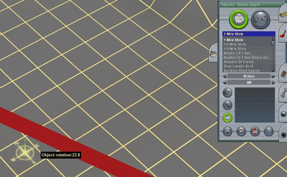
The big but, is that the bearing value shown on the rotation tool pop-up box works backwards!:confused:

In this example I’ve laid the 1 mile stick at the required 22.8 degrees, but it has rotated to a north westerly direction, not the true bearing in the north east!

I have used a protractor, 360 Degree Large Protractor <kuid:45676:23069>, for finding bearings to an accuracy of one degree, using the 1 mile stick to extend the bearing. It’s much less confusing than the “backward” readings of the rotation tool.

However if you want to be more precise than this, the correct rotation orientation needs to be calculated. Subtract your required value from 360 first, and then rotate to the calculated value (337.2). That should place the stick in the required direction. Lay your tack against that.

Of course, in more recent versions, the backward reading rotation problem (like the inaccurate Imperial measurement) may well have been corrected. I’m not familiar with every version.

228degrees_zps8196cd2a.jpg
 
My terrain is a little flat in that area and my satellite images that TransDem gave me to use are a "little" offset.
Well, if it's TransDEM-generated terrain and maps or aerial images georeferenced in TransDEM, the images should be spot-on, with no offset at all.
 
Thanks for the responses. I'll take a look at the protractor and mile-stick.

geophil,

The terrain looks great! The offset is probably due to human-error (that's me :o ). The satellite images I was referring to were the generated UTM tile objects I made from Google Earth screenshots. When I put them in Surveyor, they lined up a little to the right of points that I know should be on the raised terrain for the track. Some areas, as you say, were spot-on, but others didn't quite match up. I can post some screen shots if you like.

Andrew
 
If you used the placemark method, you might have shifted the image unintentionally, which means the placemark is no longer in the centre of the image screenshot. The alternative method is to use the TransDEM Map Tile client to acquire ortho-images. That way, georeferencing is completely automatic.
 
geophil,

You're absolutely right, using the MS Virtual Earth ortho photos in the map tile client gave me much better results. Another thing that that threw my thinking off was that in the particular area I'm modeling, there was an older line right besides the current one. I thought the current tracks should be in the center of the raised terrain as it approaches the river, when in fact they are to the right of the center-line of the raised terrain. Here's a screenshot from TransDEM using the MS Ortho photo against the Trenton West USGS NED DEM. I circled the old pillars from the old line that used to be there.

http://i1173.photobucket.com/albums/r584/a2j11j4/Models 2D and 3D/MSOrtho.jpg

Plus, the protractor and mile sticks (and some parallel track laying tools) are solving my heading problem nicely. From what I can tell, mezzoprezzo, the compass heading direction is still the same in TS12 as TS2004. I have to use 337.2 and 67.2 with some assets, but that's no big deal.

Thanks! :)
 
Back
Top