Rocks Village Bridge - totally awesome!

JCitron

Trainzing since 12-2003
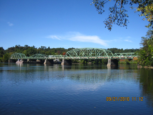
I've driven over this bridge more than once in my life and crossed it again today as I brought my cat to the vet in Newburyport. This is a swing drawbridge at the third span from the left. That alone is unique given its shape, but it's the combination of various truss types such as the Pratt pony, Warren, and Pennsylvania Truss bridges, which makes this even neater. The bridge has been recently updated so it can withstand a few more decades, at least of road traffic. It was originally built in 1883 by the Boston Bridge Works and updated over time, and has some historical significance due to its various bridge structures.

http://historicbridges.org/bridges/browser/?bridgebrowser=massachusetts/rocksvillage/
7118720955_d2c9f8ba8a_z.jpg
 
Neat. Really shows that one bridge can incorporate multiple styles of spans. So the next time I mix and match, this will be my inspiration.
 
I've done that myself and it's great to see a prototype like this as a model to follow. The problem is bridges don't like to be combined very well and I've had some odd things happen to the connecting bridges with track, that looks like a bridge, ending up in a twisted knot.

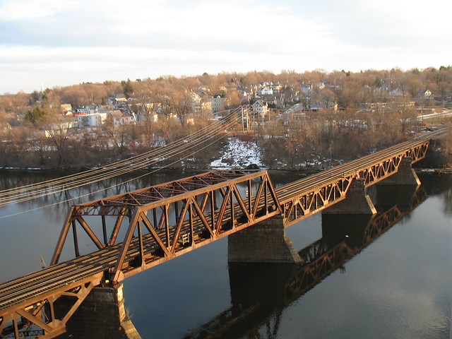
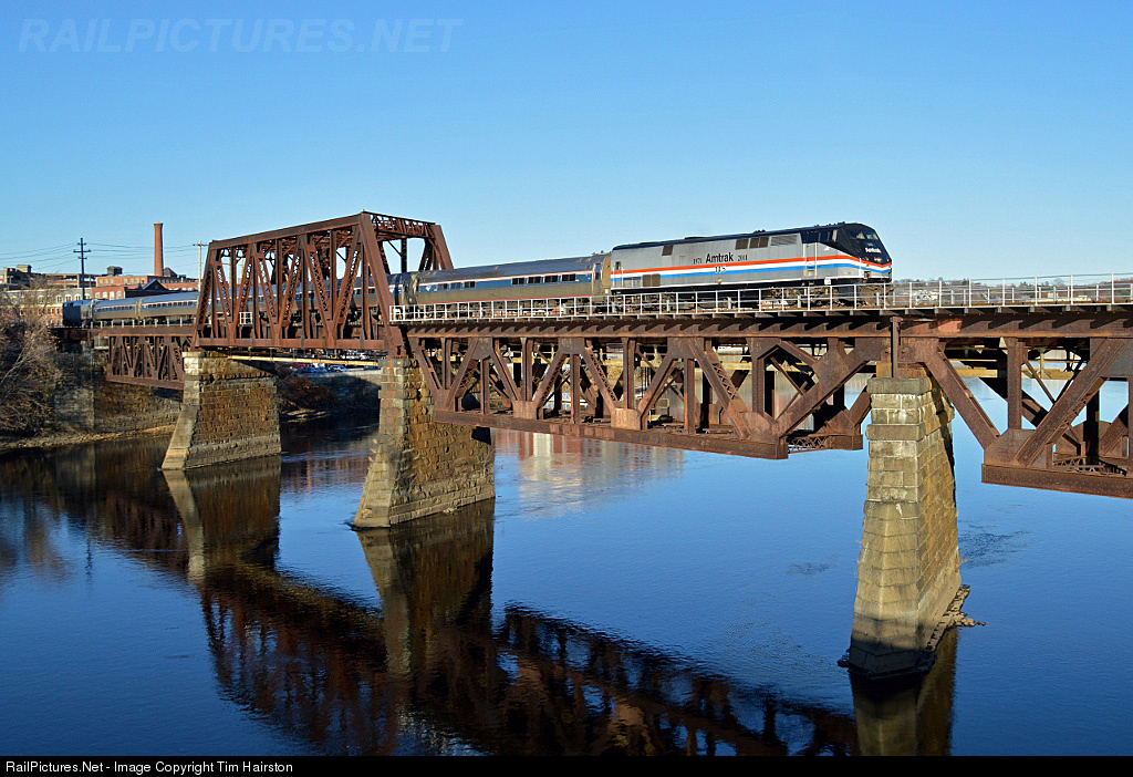
Here's another example, also in Haverhill. This is the Boston and Maine Merrimack River Bridge a few miles upstream between Bradford and Haverhill. This bridge isn't even straight and the piers are at a slight skew which makes placing it on the River difficult. I gave up after my knotted bridge splines. We're looking towards the south towards Bradford. To the left the track splits on a deck girder bridge to what was once 3 tracks going into the station. The third track, on the left side, not seen, once served the station as a termination point for local trains and RPOs, and also branched off to serve an LCL warehouse and small lumber yard. All of this is gone now. The third span across Washington Street was pulled down last year as part of the $110 Million bridge redecking and rebuilding project which is going on now.

2268586571_99679b81f4_z.jpg


Towards Haverhill...

7621.1416092081.jpg
 
Thanks, Ben for the offer. I'll see what I can find, but I've looked before and found nothing in any detail on any bridge.

What sources would us recommend?
 
I don't do research so have no idea where to look. There are places that list bridges from all over the country (sort of like a register of bridges) but I haven't a clue where they are or how to access them.

What I need is:
1. Overall length and the length of the individual spans.
2. Height of rails above the water.
3. Number of tracks, center to center spacing if more then 1, and gauge if not std ga.
4. Is it open or closed deck (open deck means you can see the water between the ties).
5. Are any spans moveable (open and close) and if so how (rotate or lift).
6. Photos of the entire span, individual spans, piers, and end bulkheads.
7. Texture colors if different from what's in the photo above.

This should keep you busy for a while (tho I hope you get lucky).

EDIT: Just for grins I did a search for Rocks Village Bridge and came up with about 20 or so photos. I'll print the relevant ones out but I still need the dimensional info. I also see which one is the movable span and its a swing bridge (and a road bridge to) so I guess I don't need the track info, lol.

Ben

Ben
 
Last edited:
Thanks for the hints. I'll see what I can find.

Yes, Rocks Village Bridge is a road bridge. The swing span is on the left in my photo above. I read somewhere it's something like 800 or so feet long, which makes sense because the river begins to widen there and begins to become tidal, as it heads towards Newburyport and the Atlantic Ocean.
 
Last edited:
I did a small amount of looking and what I found says 812 ft overall but didn't see any info on the individual span lengths or photos of the end bulkheads (where the pavement on the bridge stops and the pavement on the ground starts).

Ben
 
I did a small amount of looking and what I found says 812 ft overall but didn't see any info on the individual span lengths or photos of the end bulkheads (where the pavement on the bridge stops and the pavement on the ground starts).

Ben

The information is very vague. I did contact the MASSDOT about another bridge, but got no information back as in completely ignored. If only there were plans... With the weather becoming nicer day by day, I may plan a short road trip and take a few pics. I'm afraid the police will probably "ask some questions" if I get caught taking pictures. The cops up over in West Newbury are not very nice, which is on the other side of the bridge.

Mick. The cat is nervous and scratches and chews herself. Every time I journey with her to the vet, it's another $100 or more!

John
 
If it was Govt funded there should be plans somewhere, trouble is in this day and age they would probably throw you in jail if you asked for them
 
If you can get a photo of the entire bridge directly from the side I can do a bit of ratio-n-proportion since the overall length is known. Won't be 100% accurate but might be reasonably close. Just a thought.

Plus if we can the length of one span R-n-P again might allow me to get close to the other span lengths.

EDIT: Forget the above - I just found the lengths of the individual spans plus the road is 22 ft above the water.

Ben
 
Last edited:
I think that is a standard that varies a bit railroad to railroad. 11 ft is the absolute minimum for straight track.

I usually use 16 ft unless asked for something different but admittedly 16 ft is probably a bit wide.

Ben
 
If you can get a photo of the entire bridge directly from the side I can do a bit of ratio-n-proportion since the overall length is known. Won't be 100% accurate but might be reasonably close. Just a thought.

Plus if we can the length of one span R-n-P again might allow me to get close to the other span lengths.

EDIT: Forget the above - I just found the lengths of the individual spans plus the road is 22 ft above the water.

Ben

Thanks Ben for finding that stuff.

I never realized how low the crossing is at that point because the road on the Haverhill side (left side in photo) seems quite high, then climbs a bit to cross the river.

No need to be accurate. The bridge has been modified/updated a few times in it's lifetime. :)

Thanks again for your work on this.
 
Back
Top